185.160.5.232 - IP Lookup: Free IP Address Lookup, Postal Code Lookup, IP Location Lookup, IP ASN, Public IP
Country:
Region:
City:
Location:
Time Zone:
Postal Code:
ISP:
ASN:
language:
User-Agent:
Proxy IP:
Blacklist:
IP information under different IP Channel
ip-api
Country
Region
City
ASN
Time Zone
ISP
Blacklist
Proxy
Latitude
Longitude
Postal
Route
db-ip
Country
Region
City
ASN
Time Zone
ISP
Blacklist
Proxy
Latitude
Longitude
Postal
Route
IPinfo
Country
Region
City
ASN
Time Zone
ISP
Blacklist
Proxy
Latitude
Longitude
Postal
Route
IP2Location
185.160.5.232Country
Region
limburg
City
posterholt
Time Zone
Europe/Amsterdam
ISP
Language
User-Agent
Latitude
Longitude
Postal
ipdata
Country
Region
City
ASN
Time Zone
ISP
Blacklist
Proxy
Latitude
Longitude
Postal
Route
Popular places and events near this IP address

Ambt Montfort
Distance: Approx. 5964 meters
Latitude and longitude: 51.11666667,5.95
Ambt Montfort (Dutch pronunciation: [ɑmpt ˈmɔntfɔrt] ) is a former municipality in the Dutch province of Limburg. In 1991, the municipalities of Montfort, Posterholt, Reutje and Sint Odiliënberg merged. The original name of the merged municipality was "Posterholt", but it was changed in "Ambt Montfort" in 1994.

Roerdalen
Municipality in Limburg, Netherlands
Distance: Approx. 3835 meters
Latitude and longitude: 51.15,6
Roerdalen (Dutch: [ruːrˈdaːlə(n)] ; Limburgish: Roerdale [ʀuːʀˈdaːlə]) is a municipality in the southeastern Netherlands, in the province of Limburg. As of January 2021, it had about 20580 inhabitants and borders Germany. Roerdalen is the renaming of the municipality of Melick en Herkenbosch in 1993.

Sint Odiliënberg
Village in Limburg, Netherlands
Distance: Approx. 3132 meters
Latitude and longitude: 51.14305556,6.00277778
Sint Odiliënberg (Dutch pronunciation: [sɪnt oːˈdilijə(m)bɛr(ə)x]) is a village in southeast Netherlands, It is located in Roerdalen, Limburg, in the Roer River valley.

Vlodrop
Village in Limburg, Netherlands
Distance: Approx. 2939 meters
Latitude and longitude: 51.13333333,6.07361111
Vlodrop (Limburgish: Vlórp, pronounced [ˈvlʊʀ(ə)p]) is a village in the south-eastern part of The Netherlands in the municipality of Roerdalen. The village is situated near the German border, about 8 km southeast of Roermond.
Etsberg
Hamlet in Limburg, Netherlands
Distance: Approx. 4697 meters
Latitude and longitude: 51.13333333,6.1
Etsberg (Limburgish: Ètsberg) is a hamlet in the Dutch province of Limburg. It is a part of the municipality of Roerdalen, and lies about 9 km southeast of Roermond. It was first mentioned between 1803 and 1820 as Etzenberg.
Roskam, Netherlands
Hamlet in Limburg, Netherlands
Distance: Approx. 2627 meters
Latitude and longitude: 51.1307,5.999
Roskam is a hamlet in the Dutch municipality of Roerdalen. It is located between the larger towns of Posterholt and Sint Odiliënberg. Roskam is not a statistical entity, and the postal authorities have placed it under Sint Odiliënberg.
Montfort, Netherlands
Small city in Limburg, Netherlands
Distance: Approx. 6243 meters
Latitude and longitude: 51.12916667,5.94583333
Montfort (Limburgish: Mofert) is a small city in the Dutch province of Limburg. Montfort has about 3,000 inhabitants. It lies about 8 km south of Roermond.
Melick en Herkenbosch
Municipality in Limburg, Netherlands
Distance: Approx. 3874 meters
Latitude and longitude: 51.157923,6.040249
Melick en Herkenbosch is a former municipality in the Dutch province of Limburg. It covered the villages of Melick and Herkenbosch. In 1991, the municipality merged with Vlodrop, and in 1993, it changed its name to Roerdalen.

Posterholt
Village in Limburg, Netherlands
Distance: Approx. 155 meters
Latitude and longitude: 51.12222222,6.03611111
Posterholt is a village in the Dutch province of Limburg. It is located in the municipality of Roerdalen.
Reutje
Hamlet in Limburg, Netherlands
Distance: Approx. 1973 meters
Latitude and longitude: 51.12916667,6.00805556
Reutje or 't Reutje (Dutch: [(ət) ˈrøːtɕə]; Limburgish: 't Räötje [ət ˈʀœːtʃə]) is a hamlet in Dutch Limburg. It belongs to the municipality of Roerdalen. It lies a few km from Sint Odiliënberg.

Roertunnel
Tunnel
Distance: Approx. 6211 meters
Latitude and longitude: 51.17444444,5.99916667
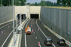
The Roertunnel is a 2.45 km long land tunnel in Roermond, Netherlands. Opening in 2008, it is one of the longest land tunnels for road traffic in the Netherlands. The tunnel is a part of the A73-south highway, connecting the A73-north in Venlo to the A2 near Echt.

Lyceum Schöndeln
School in CK Roermond, Netherlands
Distance: Approx. 5746 meters
Latitude and longitude: 51.1705,6.0014
Lyceum Schöndeln is a secondary school in Roermond, Netherlands. It combines a havo, an atheneum and a gymnasium and incorporates specialisations in both the arts (cultuurprofielschool) and the exact sciences (technasium). The school was formed in 2007 from the merger of the Stedelijk Lyceum and the Bisschoppelijk College Schöndeln.
Weather in this IP's area
light rain
6 Celsius
3 Celsius
5 Celsius
7 Celsius
1005 hPa
85 %
1005 hPa
1000 hPa
10000 meters
4.63 m/s
9.77 m/s
220 degree
75 %

