Country:
 Belgium
Region:
City:
Latitude and Longitude:
Time Zone:
Postal Code:
IP information under different IP Channel
ip-api
Country
Region
City
ASN
Time Zone
ISP
Blacklist
Proxy
Latitude
Longitude
Postal
Route
Luminati
Country
BERegion
vlg
City
hooglede
ASN
Time Zone
Europe/Brussels
ISP
Fluvius System Operator CV
Latitude
Longitude
Postal
IPinfo
Country
Region
City
ASN
Time Zone
ISP
Blacklist
Proxy
Latitude
Longitude
Postal
Route
db-ip
Country
Region
City
ASN
Time Zone
ISP
Blacklist
Proxy
Latitude
Longitude
Postal
Route
ipdata
Country
Region
City
ASN
Time Zone
ISP
Blacklist
Proxy
Latitude
Longitude
Postal
Route
Popular places and events near this IP address
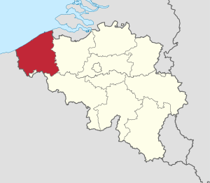
West Flanders
Province of Belgium
Distance: Approx. 6075 meters
Latitude and longitude: 51,3
West Flanders (Dutch: West-Vlaanderen [ˌʋɛst ˈflaːndərə(n)] ; West Flemish: West-Vloandern [βæst ˈflɒːndərn̩]; French: Flandre-Occidentale [flɑ̃dʁ ɔksidɑ̃tal]; German: Westflandern [ˈvɛstˌflandɐn] ) is the westernmost province of the Flemish Region, in Belgium. It is the only coastal Belgian province, facing the North Sea to the northwest. It has land borders with the Dutch province of Zeeland to the northeast, the Flemish province of East Flanders to the east, the Walloon province of Hainaut in the south and the French department of Nord to the west.

Kortemark
Municipality in the province of West Flanders, Belgium
Distance: Approx. 6747 meters
Latitude and longitude: 51.03333333,3.03333333
Kortemark (Dutch pronunciation: [ˈkɔrtəmɑr(ə)k]), also previously Cortemarck, is a municipality located in the Belgian province of West Flanders. The municipality comprises the towns of Handzame, Kortemark, Werken and Zarren. On January 1, 2006, Kortemark had a total population of 11,976.

Hooglede
Municipality in Flemish Community, Belgium
Distance: Approx. 332 meters
Latitude and longitude: 50.98333333,3.08333333
Hooglede (Dutch pronunciation: [ˈɦoːxˌleːdə]; West Flemish: Ooglee) is a municipality located in the Belgian province of West Flanders. The municipality comprises the towns of Gits and Hooglede proper. On January 1, 2006, Hooglede had a total population of 9,831.

Roeselare
City and municipality in Flemish Community, Belgium
Distance: Approx. 5833 meters
Latitude and longitude: 50.93333333,3.11666667
Roeselare (Dutch: [ˈrusəˌlaːrə] ; West Flemish: Roeseloare; French: Roulers [ʁulɛʁs]) is a Belgian city and municipality in the Flemish province of West Flanders. The municipality comprises the city of Roeselare proper and the towns of Beveren, Oekene and Rumbeke. The name of the city is derived from two Germanic words meaning "reed" and "open space", i.e., a marsh in a forest glade.
Staden
Municipality in Flemish Community, Belgium
Distance: Approx. 4525 meters
Latitude and longitude: 50.98333333,3.01666667
Staden (Dutch pronunciation: [ˈstaːdə(n)]; West Flemish: Stoan [stɒːn]) is a village and rural municipality in the Belgian province of West Flanders. The municipality has around 11 000 inhabitants. In the local West-Flemish dialect, the d is not pronounced, which results in Stoan as pronunciation.
Rodenbach Brewery
Belgian brewery
Distance: Approx. 5495 meters
Latitude and longitude: 50.946495,3.13761
Rodenbach is a brewery in Roeselare, Belgium, now owned by Palm Breweries. It is noted for its barrel-aged sour beers in the Flemish red style.

Schiervelde Stadion
Distance: Approx. 3611 meters
Latitude and longitude: 50.952087,3.105354
Stadion Schiervelde (official name) (Dutch pronunciation: [ˈsxiːrvɛldə ˌstaːdijɔn]) is a multi-use stadium in Roeselare, Belgium. It was used mostly for football matches and was the home ground of K.S.V. Roeselare until 2020. The stadium has a capacity of 8,340.

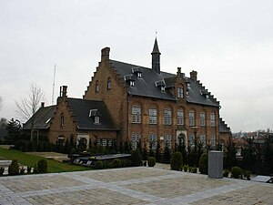
Hooglede German war cemetery
Cemetery in Belgium
Distance: Approx. 925 meters
Latitude and longitude: 50.97805556,3.09361111
The Hooglede German war cemetery (Deutscher Soldatenfriedhof Hooglede in German) is a military cemetery in the Belgian town of Hooglede, six kilometer northwest of Roeselare. It is located at the east side of Hooglede.

Oostnieuwkerke
Distance: Approx. 5706 meters
Latitude and longitude: 50.93333333,3.05
Oostnieuwkerke is a Belgian village in the province of West Flanders. It is part of the municipality of Staden. There are more than 3400 inhabitants and Oostnieuwkerke lies closer to the town Roeselare than it is to the main village Staden.

Roeselare railway station
Railway station in West Flanders, Belgium
Distance: Approx. 4942 meters
Latitude and longitude: 50.94888889,3.13027778
Station Roeselare is a Belgian railway station on railway line 66 (Brugge – Kortrijk) in the city of Roeselare.
Minor Seminary, Roeselare
Distance: Approx. 5195 meters
Latitude and longitude: 50.94324,3.12529
The Minor Seminary, Roeselare (Dutch: Klein Seminarie Roeselare; est. 1806) is a diocesan secondary school in Roeselare, West Flanders, Belgium. Initially primarily a preparatory institution for the Major Seminary, Bruges, it is now a substantial secondary school for the local community.

Transport Office of the Devastated Territories of West Flanders
Defunct Belgian government agency
Distance: Approx. 5338 meters
Latitude and longitude: 50.946322,3.13418
The Belgian Transport Office of the Devastated Territories of West Flanders (Flemish: Vervoerdienst der Verwoeste Gewesten, French: Exploitation des Transports des Régions Dévastées, ETRD) operated 260 road transport vehicles and a 700 km (430 mi) long light railway network with a track gauge of 600 mm (1 ft 11+5⁄8 in) during the post-war period of World War I in West Flanders.
Weather in this IP's area
overcast clouds
7 Celsius
7 Celsius
6 Celsius
8 Celsius
1010 hPa
90 %
1010 hPa
1004 hPa
10000 meters
0.89 m/s
0.89 m/s
100 %
08:09:27
16:56:40