Country:
 Belgium
Region:
City:
Latitude and Longitude:
Time Zone:
Postal Code:
IP information under different IP Channel
ip-api
Country
Region
City
ASN
Time Zone
ISP
Blacklist
Proxy
Latitude
Longitude
Postal
Route
IPinfo
Country
Region
City
ASN
Time Zone
ISP
Blacklist
Proxy
Latitude
Longitude
Postal
Route
MaxMind
Country
Region
City
ASN
Time Zone
ISP
Blacklist
Proxy
Latitude
Longitude
Postal
Route
Luminati
Country
BERegion
vlg
City
antwerp
ASN
Time Zone
Europe/Brussels
ISP
Arcadiz Telecom NV
Latitude
Longitude
Postal
db-ip
Country
Region
City
ASN
Time Zone
ISP
Blacklist
Proxy
Latitude
Longitude
Postal
Route
ipdata
Country
Region
City
ASN
Time Zone
ISP
Blacklist
Proxy
Latitude
Longitude
Postal
Route
Popular places and events near this IP address
Radio Centraal
Radio station in Antwerp, Belgium
Distance: Approx. 356 meters
Latitude and longitude: 51.22014444,4.39657778
Radio Centraal is a Belgian "underground" radio station in the old city center of Antwerp. It began broadcasting on 31 October 1980 on 103.9 FM as one of the first pirate radio stations which started around the country in protest against the broadcasting monopoly of the national state networks. It always was and still remains an independent radio project with many experimental programmes and niche music.

Het Steen
Fortress in Antwerp, Belgium
Distance: Approx. 557 meters
Latitude and longitude: 51.2227,4.3974
Het Steen is a medieval fortress in the old city centre of Antwerp, Belgium, one of Europe's biggest ports. The surviving structure was built between 1200 and 1225 as a gateway to a larger castle of the Dukes of Brabant which was demolished in the 19th century. As the first stone fortification (city wall) of Antwerp, Het Steen is Antwerp's oldest building and used to be part of its oldest urban centre.

Plantin Press
Distance: Approx. 462 meters
Latitude and longitude: 51.21829,4.39816
The Plantin Press at Antwerp was one of the focal centers of the fine printed book in the 16th century.

Plantin–Moretus Museum
Printing museum in Antwerp, Belgium
Distance: Approx. 435 meters
Latitude and longitude: 51.21833333,4.39777778
The Plantin–Moretus Museum (Dutch: Plantin-Moretusmuseum) is a printing museum in Antwerp, Belgium which focuses on the work of the 16th-century printers Christophe Plantin and Jan Moretus. It is located in their former residence and printing establishment, the Plantin Press, at the Vrijdagmarkt (Friday Market) in Antwerp, and has been a UNESCO World Heritage Site since 2005.

Antwerp City Hall
Distance: Approx. 573 meters
Latitude and longitude: 51.2213,4.3992
The City Hall (Dutch: ) of Antwerp, Belgium, stands on the western side of that city's Grote Markt (main square). Erected between 1561 and 1565, after designs made by Cornelis Floris de Vriendt and several other architects and artists, this Renaissance building incorporates both Flemish and Italian influences. The building is listed as one of the Belfries of Belgium and France, a UNESCO World Heritage Site.

St. Andrew's Church, Antwerp
Distance: Approx. 544 meters
Latitude and longitude: 51.2164,4.3981
St. Andrew’s Church (Dutch: Sint-Andrieskerk) is a Catholic church in Antwerp built in the 16th century. Its exterior is mainly characterised by a late-Gothic style while its interior is predominantly executed in Baroque style.

Guirlande Antwerpen
Distance: Approx. 500 meters
Latitude and longitude: 51.21508333,4.39458333
The Guirlande Antwerpen [ɡiʁ.lɑd] (Dutch for Garland of Antwerp) is a sculpture located on the storefront of an antique shop in Antwerp's antique district. It is at Kloosterstraat 81 in the St. Andries quarter.
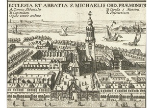
St. Michael's Abbey, Antwerp
Distance: Approx. 479 meters
Latitude and longitude: 51.215,4.3932
St Michael's Abbey in Antwerp was a Premonstratensian abbey founded in 1124 by Norbert of Xanten and laid waste during the French Revolutionary Wars. In 1807 a semaphore station was installed in the tower of the church. The buildings were demolished in 1831.
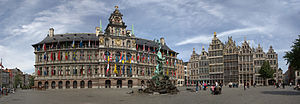
Grote Markt, Antwerp
Square in Antwerp, Belgium
Distance: Approx. 598 meters
Latitude and longitude: 51.22111111,4.39972222
The Grote Markt (Dutch: [ˌɣroːtə ˈmɑr(ə)kt] ; "Big Market") is the central square of Antwerp, Belgium, situated in the heart of the old city quarter. It is surrounded by the city's Renaissance Town Hall, as well as numerous guildhalls with elaborate façades, the majority of which are reconstructions from the 19th and early 20th century, approximating paintings of the square by Flemish artists. A few of the guildhall façades, such as that of Sint-Joris's are intact originals entirely dating back to the 16th century.

St. Walburga Church, Antwerp
Distance: Approx. 480 meters
Latitude and longitude: 51.22203889,4.39688333
St. Walburga Church (Dutch: Sint-Walburgiskerk) or Burchtkerk was a Roman Catholic parish church in Antwerp, modern-day Belgium. It was demolished in 1817.

Brabo Fountain
Monumental fountain in Antwerp, Belgium
Distance: Approx. 599 meters
Latitude and longitude: 51.22118,4.39969
The Brabo Fountain (Dutch: Brabofontein) is a eclectic-style fountain-sculpture located in the Grote Markt (main square) of Antwerp, Belgium, in front of the City Hall. The fountain, dating from 1887, contains a bronze statue by the sculptor Jef Lambeaux depicting the city's legendary founder, Silvius Brabo, throwing the severed hand of the giant Druon Antigoon into the river Scheldt. It received protected status in 1982.
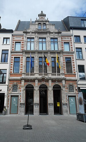
DIVA Museum for Diamonds, Jewellery and Silver
Distance: Approx. 505 meters
Latitude and longitude: 51.22112,4.39827
DIVA Museum for Diamonds, Jewellery and Silver is a museum that opened in Antwerp, Belgium, in 2018. It merged the collections of the former Antwerp Diamond Museum (1972–2012) and Sterckshof silver museum (1992–2014) in a single institution. The museum's collection "features over 500 objects that detail the story of Antwerp's history with diamonds and gemstones".
Weather in this IP's area
broken clouds
14 Celsius
14 Celsius
13 Celsius
14 Celsius
1006 hPa
92 %
1006 hPa
1006 hPa
10000 meters
6.69 m/s
210 degree
75 %
07:43:18
19:20:32