Country:
 Belgium
Region:
City:
Latitude and Longitude:
Time Zone:
Postal Code:
IP information under different IP Channel
ip-api
Country
Region
City
ASN
Time Zone
ISP
Blacklist
Proxy
Latitude
Longitude
Postal
Route
IPinfo
Country
Region
City
ASN
Time Zone
ISP
Blacklist
Proxy
Latitude
Longitude
Postal
Route
MaxMind
Country
Region
City
ASN
Time Zone
ISP
Blacklist
Proxy
Latitude
Longitude
Postal
Route
Luminati
Country
BERegion
vlg
City
kraainem
ASN
Time Zone
Europe/Brussels
ISP
CHIREC asbl
Latitude
Longitude
Postal
db-ip
Country
Region
City
ASN
Time Zone
ISP
Blacklist
Proxy
Latitude
Longitude
Postal
Route
ipdata
Country
Region
City
ASN
Time Zone
ISP
Blacklist
Proxy
Latitude
Longitude
Postal
Route
Popular places and events near this IP address

Saint-Gilles, Belgium
Municipality of the Brussels-Capital Region, Belgium
Distance: Approx. 1636 meters
Latitude and longitude: 50.81666667,4.35
Saint-Gilles (French, pronounced [sɛ̃ ʒil] ) or Sint-Gillis (Dutch, pronounced [sɪntˈxɪlɪs] ) is one of the 19 municipalities of the Brussels-Capital Region, Belgium. Located in the southern part of the region, it is bordered by the City of Brussels, Anderlecht, Forest and Ixelles. In common with all of Brussels' municipalities, it is legally bilingual (French–Dutch), but predominantly French-speaking nowadays.

Uccle
Municipality of the Brussels-Capital Region, Belgium
Distance: Approx. 704 meters
Latitude and longitude: 50.8,4.33333333
Uccle (French, pronounced [ykl(ə)]) or Ukkel (Dutch, pronounced [ˈʏkəl] ) is one of the 19 municipalities of the Brussels-Capital Region, Belgium. Located in the southern part of the region, it is bordered by the City of Brussels, Forest, Ixelles, and Watermael-Boitsfort, as well as the Flemish municipalities of Drogenbos, Linkebeek and Sint-Genesius-Rode. In common with all of Brussels' municipalities, it is legally bilingual (French–Dutch).

Royal Observatory of Belgium
Observatory
Distance: Approx. 1259 meters
Latitude and longitude: 50.798179,4.358628
The Royal Observatory of Belgium (French: Observatoire Royal de Belgique; Dutch: Koninklijke Sterrenwacht van België) has been situated in the Uccle municipality of Brussels since 1890. The Royal Observatory was first established in Saint-Josse-ten-Noode in 1826 by King William I of the Netherlands under the impulse of Adolphe Quetelet. It was home to a 100 cm (39 in) diameter aperture Zeiss reflector in the first half of the 20th century, one of the largest telescopes in the world at the time.

Forest National
Multi-purpose arena in Brussels, Belgium
Distance: Approx. 1375 meters
Latitude and longitude: 50.80972222,4.32611111
Forest National (French) or Vorst Nationaal (Dutch) is a multi-purpose arena located in the municipality of Forest in Brussels, Belgium. The arena can hold more than 8,000 people. It hosts indoor sporting events as well as concerts done by a wide variety of artists.
Belgian Institute for Space Aeronomy
Research institute
Distance: Approx. 1232 meters
Latitude and longitude: 50.796785,4.356998
The Royal Belgian Institute for Space Aeronomy (BIRA-IASB) (Dutch: Koninklijk Belgisch Instituut voor Ruimte-Aeronomie - BIRA, French: Institut royal d'aéronomie spatiale de Belgique - IASB) is a Belgian federal scientific research institute. Created in 1964, its main tasks are research and public service in space aeronomy, which is the physics and chemistry of the atmosphere of the Earth and other planets, and of outer space. The scientists rely on ground-based, balloon-, air- or space-borne instruments and computer models.

Villa Bloemenwerf
Historic Art Nouveau house in Brussels, Belgium
Distance: Approx. 783 meters
Latitude and longitude: 50.79580556,4.34341667
The Villa Bloemenwerf (Dutch: [ˈblumənwɛrf]) is the former residence of the Belgian painter, architect and interior designer Henry van de Velde, built in 1895. It is located at 102, avenue Vanderaey/Vanderaeylaan in the Uccle municipality of Brussels, Belgium. Van de Velde designed the house and its interior, as well as the furnishings, partially drawing inspiration from William Morris' Red House in Bexleyheath, London.

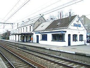
Saint-Job railway station
Railway station in Brussels, Belgium
Distance: Approx. 1679 meters
Latitude and longitude: 50.7941,4.3618
Saint-Job railway station (French: Gare de Saint-Job) or Sint-Job railway station (Dutch: Station Sint-Job) is a railway station in the municipality of Uccle in Brussels, Belgium. The station, operated by the National Railway Company of Belgium (NMBS/SNCB), is located on line 26, between Boondael and Moensberg railway stations. The station is named after the nearby Place de Saint-Job/Sint-Jobsplein.

Uccle-Stalle railway station
Railway station in Belgium
Distance: Approx. 1288 meters
Latitude and longitude: 50.8024,4.324
Uccle-Stalle railway station (French: Gare d'Uccle-Stalle) or Ukkel-Stalle railway station (Dutch: Station Ukkel-Stalle) is a railway station in the municipality of Uccle in Brussels, Belgium. The station is operated by the National Railway Company of Belgium (NMBS/SNCB) and located on line 124, between Forest-East and Uccle-Calevoet railway stations. It is named after the Stalle neighbourhood in Uccle.
Uccle-Calevoet railway station
Railway station in Brussels, Belgium
Distance: Approx. 1410 meters
Latitude and longitude: 50.7919,4.3321
Uccle-Calevoet railway station (French: Gare d'Uccle-Calevoet) or Ukkel-Kalevoet railway station (Dutch: Station Ukkel-Kalevoet) is a railway station in the municipality of Uccle in Brussels, Belgium. The station is operated by the National Railway Company of Belgium (NMBS/SNCB) and located on line 124, between Uccle-Stalle and Linkebeek railway stations. It is named after the Calevoet/Kalevoet neighbourhood in Uccle.

French Lycée in Brussels
School in Brussels, Belgium
Distance: Approx. 1564 meters
Latitude and longitude: 50.78889,4.34542
The Lycée français Jean Monnet de Bruxelles (literally, the "Jean Monnet French High School of Brussels"), or LFB, is a school located in Uccle, Brussels, Belgium. It is directly operated by the Agency for French Education Abroad (AEFE), an agency of the French government. The LFB follows the French study curriculum and has students from nursery school up to the French baccalauréat.

Van Buuren Museum & Gardens
Museum of European artworks from 15th to 19th century, in Brussels, Belgium
Distance: Approx. 1143 meters
Latitude and longitude: 50.81005,4.35381389
The Van Buuren Museum & Gardens (French: Musée & Jardins van Buuren; Dutch: Van Buuren Museum & Tuinen) are a former private house with extensive gardens, now a museum and park in Uccle, a municipality of Brussels, Belgium. The house was built from 1924 to 1928, in the Amsterdam School style, for the banker and art collector David Van Buuren and his wife Alice Piette. It was decorated by both of them as a Gesamtkunstwerk to present their art collection, which extends from the 15th to the 20th century, in a rich Art Deco interior.

Church of St. Augustine, Forest
Church in Forest, Belgium
Distance: Approx. 1564 meters
Latitude and longitude: 50.81638889,4.33666667
The Church of St. Augustine (French: Église Saint-Augustin; Dutch: Sint-Augustinuskerk) is a Roman Catholic parish church located in Forest, a municipality of Brussels, Belgium. It is dedicated to Saint Augustine.
Weather in this IP's area
broken clouds
12 Celsius
12 Celsius
11 Celsius
13 Celsius
1007 hPa
80 %
1007 hPa
1000 hPa
10000 meters
6.69 m/s
240 degree
75 %
07:43:18
19:20:56