Country:
Region:
City:
Latitude and Longitude:
Time Zone:
Postal Code:
IP information under different IP Channel
ip-api
Country
Region
City
ASN
Time Zone
ISP
Blacklist
Proxy
Latitude
Longitude
Postal
Route
Luminati
Country
Region
34
City
duecarrare
ASN
Time Zone
Europe/Rome
ISP
Net Global Srl
Latitude
Longitude
Postal
IPinfo
Country
Region
City
ASN
Time Zone
ISP
Blacklist
Proxy
Latitude
Longitude
Postal
Route
db-ip
Country
Region
City
ASN
Time Zone
ISP
Blacklist
Proxy
Latitude
Longitude
Postal
Route
ipdata
Country
Region
City
ASN
Time Zone
ISP
Blacklist
Proxy
Latitude
Longitude
Postal
Route
Popular places and events near this IP address
Prato della Valle
Square in Padova, Italy
Distance: Approx. 4953 meters
Latitude and longitude: 45.39833333,11.87583333
Prato della Valle (Prà de ła Vałe in Venetian) is a 90,000-square-meter elliptical square in Padua, Italy. It is the second largest square in Italy and one of the largest in Europe. Today, the square is a large space with a green island at the center, l'Isola Memmia, surrounded by a small canal bordered by two rings of statues.
Orto botanico di Padova
Botanical garden in Padua, Italy
Distance: Approx. 4767 meters
Latitude and longitude: 45.39911111,11.88066667
The Orto Botanico di Padova is a botanical garden in Padua, in the northeastern part of Italy. Founded in June 1545 by the Venetian Republic, it is the world's oldest academic botanical garden that is still in its original location. The garden – operated by the University of Padua and owned by the Italian government – encompasses roughly 22,000 square meters (240,000 sq ft), and is known for its special collections and historical design.

Albignasego
Comune in Veneto, Italy
Distance: Approx. 4505 meters
Latitude and longitude: 45.35,11.86666667
Albignasego is a comune (municipality) in the Province of Padua in the Italian region Veneto, located about 35 kilometres (22 mi) west of Venice and about 7 kilometres (4.3 mi) south of Padua. As of 06/03/2021, it has a population of 26.006 inhabitants and an area of 21.0 square kilometres (8.1 sq mi). The municipality of Albignasego contains the main village and frazioni (hamlets) Carpanedo, Lion, Mandriola, S. Agostino, S. Giacomo.

Legnaro
Comune in Veneto, Italy
Distance: Approx. 4102 meters
Latitude and longitude: 45.35,11.96666667
Legnaro is a comune in the Province of Padua in the Italian region Veneto, located about 30 kilometres (19 mi) southwest of Venice and about 11 kilometres (7 mi) southeast of Padua. As of 31 December, 2010, it had a population of 8,594 and an area of 14.89 square kilometres (5.75 sq mi).

Ponte San Nicolò
Comune in Veneto, Italy
Distance: Approx. 1084 meters
Latitude and longitude: 45.36666667,11.93333333
Ponte San Nicolò is a comune (municipality) in the Province of Padua in the Italian region Veneto, located about 30 kilometres (19 mi) west of Venice and about 8 kilometres (5 mi) southeast of Padua. As of 31 December 2004, it had a population of 12,656 and an area of 13.5 square kilometres (5.2 sq mi). The municipality of Ponte San Nicolò contains the frazioni (subdivisions, mainly villages and hamlets) Roncaglia, Roncajette, and Rio.
Ponte Corvo (bridge)
Bridge in Padua, Italy
Distance: Approx. 4862 meters
Latitude and longitude: 45.401814,11.883706
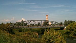
The Ponte Corvo, rarely Ponte Corbo, is a Roman segmental arch bridge across the Bacchiglione in Padua, Italy (Roman Patavium). Dating to the 1st or 2nd century AD, its three remaining arches cross a branch of the river and are today partly buried respectively walled up. The span-to-rise ratio of the bridge varies between 2.8 and 3.4 to 1, the ratio of clear span to pier thickness from 4.9 to 6.9 to 1.

Stadio Silvio Appiani
Building in Padua, Italy
Distance: Approx. 4723 meters
Latitude and longitude: 45.395,11.87527778
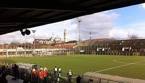
Stadio Silvio Appiani is a multi-use stadium in Padua, Italy. It was initially used as the stadium of Calcio Padova matches. It was replaced by Stadio Euganeo in 1994.

Abbey of Santa Giustina
10th-century Benedictine abbey in Padua, Italy
Distance: Approx. 4587 meters
Latitude and longitude: 45.39638889,11.87972222
The Abbey of Santa Giustina is a 10th-century Benedictine abbey complex located in front of the Prato della Valle in central Padua, region of Veneto, Italy. Adjacent to the former monastery is the basilica church of Santa Giustina, initially built in the 6th century, but whose present form derives from a 17th-century reconstruction.
AURIGA
Distance: Approx. 2782 meters
Latitude and longitude: 45.352469,11.949306
AURIGA (Antenna Ultracriogenica Risonante per l'Indagine Gravitazionale Astronomica) is an ultracryogenic resonant bar gravitational wave detector in Italy. It is at the Laboratori Nazionali di Legnaro of the Istituto Nazionale di Fisica Nucleare, near Padova. It is being used for research into gravitational waves and quantum gravity.

Reversed-Field eXperiment
Distance: Approx. 2908 meters
Latitude and longitude: 45.3912,11.9298
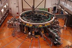
The Reversed-Field eXperiment (RFX) is the largest reversed field pinch device presently in operation, situated in Padua, Italy. It was constructed from 1985 to 1991, and has been in operation since 1992. The experiments carried out in the last two decades with two large RFP machines (MST in Madison, Wisconsin and RFX in Padova) provided new insight on the physical phenomena taking place in magnetically confined plasma dynamics.
Santa Croce, Padua
Distance: Approx. 4820 meters
Latitude and longitude: 45.393,11.8712
Santa Croce is a Roman Catholic church located on Corso Vittorio Emanuele 178 in Padua, Veneto region, Italy.

ITER Neutral Beam Test Facility
Distance: Approx. 2798 meters
Latitude and longitude: 45.39055556,11.92777778
The ITER Neutral Beam Test Facility is a part of the International Thermonuclear Experimental Reactor (ITER) in Padova, Veneto, Italy. The facility will host the full-scale prototype of the reactor's neutral beam injector, MITICA (Megavolt ITer Injector & Concept Advancement), and a smaller prototype of its ion source, SPIDER (Source for the Production of Ions of Deuterium Extracted from a Radio frequency plasma). SPIDER started its operation in June 2018.
Weather in this IP's area
clear sky
4 Celsius
3 Celsius
1 Celsius
4 Celsius
1023 hPa
76 %
1023 hPa
1022 hPa
10000 meters
1.4 m/s
1.5 m/s
21 degree
07:11:26
16:42:44


