185.156.30.48 - IP Lookup: Free IP Address Lookup, Postal Code Lookup, IP Location Lookup, IP ASN, Public IP
Country:
 Germany
Region:
City:
Location:
Time Zone:
Postal Code:
ISP:
ASN:
language:
User-Agent:
Proxy IP:
Blacklist:
IP information under different IP Channel
ip-api
Country
Region
City
ASN
Time Zone
ISP
Blacklist
Proxy
Latitude
Longitude
Postal
Route
db-ip
Country
Region
City
ASN
Time Zone
ISP
Blacklist
Proxy
Latitude
Longitude
Postal
Route
IPinfo
Country
Region
City
ASN
Time Zone
ISP
Blacklist
Proxy
Latitude
Longitude
Postal
Route
IP2Location
185.156.30.48Country
deRegion
bayern
City
traunstein
Time Zone
Europe/Berlin
ISP
Language
User-Agent
Latitude
Longitude
Postal
ipdata
Country
Region
City
ASN
Time Zone
ISP
Blacklist
Proxy
Latitude
Longitude
Postal
Route
Popular places and events near this IP address
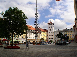
Traunstein
Town in Bavaria, Germany
Distance: Approx. 769 meters
Latitude and longitude: 47.86666667,12.63333333
Traunstein (Central Bavarian: Traunstoa) is a town in the south-eastern part of Bavaria, Germany, and is the administrative center of a much larger district of the same name. The town serves as a local government, retail, health services, transport and educational center for the wider district. The historic market square, Bavarian hospitality, local breweries, outdoor sports facilities, Easter Monday horse parade, and connections with Pope Emeritus Benedict XVI, contribute to the town's profile as a tourist destination.

Nußdorf (Chiemgau)
Municipality in Bavaria, Germany
Distance: Approx. 4776 meters
Latitude and longitude: 47.88333333,12.58333333
Nußdorf (German pronunciation: [ˈnʊsdɔʁf] ) is a municipality in the district of Traunstein in Bavaria in Germany.

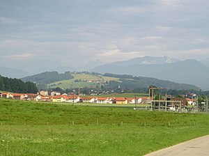
Surberg
Municipality in Bavaria, Germany
Distance: Approx. 4239 meters
Latitude and longitude: 47.86666667,12.7
Surberg is a municipality in the district of Traunstein in Bavaria, Germany. It is 90 km (55.7 miles) southeast of the Bavarian capital of Munich.

Vachendorf
Municipality in Bavaria, Germany
Distance: Approx. 2855 meters
Latitude and longitude: 47.85,12.61666667
Vachendorf is a municipality in the district of Traunstein in Bavaria, Germany.

Traun (Alz)
River in Germany
Distance: Approx. 3971 meters
Latitude and longitude: 47.83278,12.64625
The Traun (German: [tʁaʊn] ) is a river in Upper Bavaria, Germany. The nearly 29 kilometer long river is formed by the confluence of the Weiße Traun (also considered its upper course) and the Rote Traun near Siegsdorf. It passes through Traunstein and Traunreut, and flows into the Alz near Altenmarkt an der Alz.
Hochberg (Chiemgau)
Distance: Approx. 3137 meters
Latitude and longitude: 47.84138889,12.65527778
Hochberg (Chiemgau) is a mountain of Bavaria, Germany.

Rote Traun
River in Germany
Distance: Approx. 3970 meters
Latitude and longitude: 47.8328,12.6464
Rote Traun is a river of Bavaria, Germany. The 14 kilometer long river is formed at the confluence of the Falkenseebach and the Großwaldbach in Inzell. At its confluence with the Weiße Traun near Siegsdorf, the Traun is formed.

Weiße Traun
River in Baveria
Distance: Approx. 3970 meters
Latitude and longitude: 47.8328,12.6464
The Weiße Traun is a river of Bavaria, Germany. Th nearly 14 kilometer long river is formed at the confluence of the Fischbach and the Seetraun south of Ruhpolding. At its confluence with the Rote Traun near Siegsdorf, the Traun is formed.

Hofbräuhaus Traunstein
Beer brewery in Bavaria, Germany
Distance: Approx. 394 meters
Latitude and longitude: 47.8689686,12.6485124
Hofbräuhaus Traunstein is a beer brewery in Traunstein, southeastern Bavaria, Germany.

Traunstein station
Railway station in Traunstein, Germany
Distance: Approx. 375 meters
Latitude and longitude: 47.869524,12.638569
Traunstein station is the only station of the large district town of Traunstein in the German state of Bavaria. It has four main line platform tracks and two bay platform tracks and is classified by Deutsche Bahn as a category 4 station. The station is a rail junction and is located on the Rosenheim–Salzburg, Traunstein–Ruhpolding, Traunstein–Waging and Traunstein–Garching lines.
Spielwang
Ortsteil of Vachendorf in Bavaria, Germany
Distance: Approx. 4153 meters
Latitude and longitude: 47.845,12.6
Spielwang is a small village within the municipality of Vachendorf in the district of Traunstein in Bavaria, Germany. It is not far away from the Chiemsee.
Röthelbach (Traun)
River in Germany
Distance: Approx. 703 meters
Latitude and longitude: 47.8621,12.6427
Röthelbach is a small river of Bavaria, Germany. It springs southeast of Traunstein. It is a right tributary of the Traun in Traunstein.
Weather in this IP's area
overcast clouds
-2 Celsius
-2 Celsius
-4 Celsius
-2 Celsius
1024 hPa
85 %
1024 hPa
935 hPa
10000 meters
1.2 m/s
1.03 m/s
189 degree
100 %