185.155.41.199 - IP Lookup: Free IP Address Lookup, Postal Code Lookup, IP Location Lookup, IP ASN, Public IP
Country:
Region:
City:
Location:
Time Zone:
Postal Code:
IP information under different IP Channel
ip-api
Country
Region
City
ASN
Time Zone
ISP
Blacklist
Proxy
Latitude
Longitude
Postal
Route
Luminati
Country
Region
30
City
kalisz
ASN
Time Zone
Europe/Warsaw
ISP
Netcom Computers
Latitude
Longitude
Postal
IPinfo
Country
Region
City
ASN
Time Zone
ISP
Blacklist
Proxy
Latitude
Longitude
Postal
Route
IP2Location
185.155.41.199Country
Region
wielkopolskie
City
kalisz
Time Zone
Europe/Warsaw
ISP
Language
User-Agent
Latitude
Longitude
Postal
db-ip
Country
Region
City
ASN
Time Zone
ISP
Blacklist
Proxy
Latitude
Longitude
Postal
Route
ipdata
Country
Region
City
ASN
Time Zone
ISP
Blacklist
Proxy
Latitude
Longitude
Postal
Route
Popular places and events near this IP address

Kalisz
Place in Greater Poland, Poland
Distance: Approx. 857 meters
Latitude and longitude: 51.7575,18.08
Kalisz (Polish: [ˈkaliʂ] ) is a city in central Poland, and the second-largest city in the Greater Poland Voivodeship, with 97,905 residents (December 2021). It is the capital city of the Kalisz Region. Situated on the Prosna river in the southeastern part of Greater Poland, the city forms a conurbation with the nearby towns of Ostrów Wielkopolski and Nowe Skalmierzyce.

Kalisz Department
Distance: Approx. 814 meters
Latitude and longitude: 51.766667,18.083333
Kalisz Department (Polish: departament kaliski) was a unit of administrative division and local government in Polish Duchy of Warsaw in years 1807–1815. Its capital city was Kalisz, and the area was further subdivided onto 13 powiats. In 1815 it was transformed into the Kalisz Voivodeship.

Kalisz County
County in Greater Poland Voivodeship, Poland
Distance: Approx. 857 meters
Latitude and longitude: 51.7575,18.08
Kalisz County (Polish: powiat kaliski) is a unit of territorial administration and local government (powiat) in Greater Poland Voivodeship, west-central Poland. It came into being on 1 January 1999 as a result of the Polish local government reforms passed in 1998. Its administrative seat is the city of Kalisz, although the city is not part of the county (it constitutes a separate city county).

Kalisz Governorate
1867–1915 unit of Poland
Distance: Approx. 547 meters
Latitude and longitude: 51.763799,18.084363
Kalisz Governorate was an administrative-territorial unit (guberniya) of Congress Poland of the Russian Empire.

Kalisz Voivodeship (1314–1793)
Distance: Approx. 547 meters
Latitude and longitude: 51.763799,18.084363
Kalisz Voivodeship 1314–1793 (Polish: Województwo Kaliskie, Latin: Palatinatus Calisiensis) was an administrative unit of Poland from 1314 to the Second Partition of Poland in 1793. It was part of the Greater Polish Province. Its capital was in Kalisz, and together with neighboring Poznań Voivodeship, Kalisz elected general starosta of Greater Poland.

Battle of Kalisz
Battle in the Great Northern War
Distance: Approx. 857 meters
Latitude and longitude: 51.7575,18.08
The Battle of Kalisz took place on 29 October 1706 in Kalisz, Polish–Lithuanian Commonwealth during the Great Northern War. The battle was fought between an anti-Swedish army of Russians, Saxons and Poles led by Augustus the Strong and Russian general Alexander Danilovich Menshikov, and a Swedish–Polish–Lithuanian army headed by colonel Arvid Axel Mardefelt, loyal to Stanisław Leszczyński. The battle, which occurred as peace had been concluded between Sweden and Saxony, marked Sweden's only major defeat in Poland during the war and temporarily secured a major part of Greater Poland for the coalition.

Roman Catholic Diocese of Kalisz
Roman Catholic diocese in Poland
Distance: Approx. 382 meters
Latitude and longitude: 51.764247,18.088807
The Diocese of Kalisz (Latin: Dioecesis Calissiensis)) is a Latin diocese of the Catholic Church located in the city of Kalisz in the ecclesiastical province of Poznań in Poland.

Destruction of Kalisz
Sacking of a Polish City during WW1
Distance: Approx. 163 meters
Latitude and longitude: 51.7625,18.0903
The destruction of Kalisz (Polish: zburzenie Kalisza) by German troops took place from 2 August until 22 August 1914 at the beginning of World War I. The event is also known as the Pogrom of Kalisz or Poland's Louvain. The German army invaded Kalisz on 2 August 1914. The town was burnt down; only churches and public offices survived.

Szczypiorno
Neighbourhood in Kalisz, Greater Poland Voivodeship, Poland
Distance: Approx. 857 meters
Latitude and longitude: 51.7575,18.08
Szczypiorno [ʂt͡ʂɨˈpjɔrnɔ] is a municipal neighbourhood of the city of Kalisz, Poland, located in its south-western part. Formerly until 1976 a separate village at the outskirts of the city, it is best known as a seat of a World War I and Polish–Soviet War prisoner of war camp and the name-sake for szczypiorniak, the Polish language name for the game of handball.
Zagorzyn, Greater Poland Voivodeship
Village in Greater Poland Voivodeship, Poland
Distance: Approx. 1383 meters
Latitude and longitude: 51.75,18.1
Zagorzyn [zaˈɡɔʐɨn] is a village in the administrative district of Gmina Blizanów, within Kalisz County, Greater Poland Voivodeship, in west-central Poland. It lies approximately 18 kilometres (11 mi) south of Blizanów, 2 km (1 mi) south-east of Kalisz, and 109 km (68 mi) south-east of the regional capital Poznań.
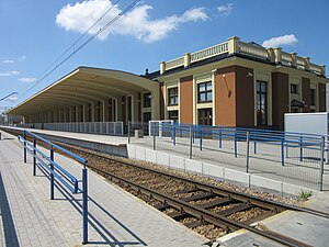
Kalisz railway station
Railway station in Kalisz, Poland
Distance: Approx. 2436 meters
Latitude and longitude: 51.74277778,18.07166667
Kalisz railway station is a railway station in Kalisz, in the Greater Poland Voivodeship, Poland. The station opened in 1902 and is located on the Łódź–Forst (Lausitz) railway. The train services are operated by PKP and Polregio.

Cathedral of St. Nicholas the Bishop in Kalisz
Cathedral in Kalisz, Poland
Distance: Approx. 356 meters
Latitude and longitude: 51.7641,18.0892
The Cathedral of St. Nicholas the Bishop in Kalisz (Polish: Katedra św. Mikołaja Biskupa w Kaliszu) is a Catholic cathedral in Kalisz, Poland.
Weather in this IP's area
few clouds
1 Celsius
-3 Celsius
1 Celsius
1 Celsius
1018 hPa
83 %
1018 hPa
1002 hPa
10000 meters
4.69 m/s
10.6 m/s
227 degree
18 %
