Country:
Region:
City:
Latitude and Longitude:
Time Zone:
Postal Code:
IP information under different IP Channel
ip-api
Country
Region
City
ASN
Time Zone
ISP
Blacklist
Proxy
Latitude
Longitude
Postal
Route
Luminati
Country
ASN
Time Zone
Europe/Madrid
ISP
Partido Socialista Obrero Espanol (PSOE)
Latitude
Longitude
Postal
IPinfo
Country
Region
City
ASN
Time Zone
ISP
Blacklist
Proxy
Latitude
Longitude
Postal
Route
db-ip
Country
Region
City
ASN
Time Zone
ISP
Blacklist
Proxy
Latitude
Longitude
Postal
Route
ipdata
Country
Region
City
ASN
Time Zone
ISP
Blacklist
Proxy
Latitude
Longitude
Postal
Route
Popular places and events near this IP address

Príncipe Pío (hill)
Historically significant hill in western Madrid, Spain
Distance: Approx. 528 meters
Latitude and longitude: 40.424,-3.718
The montaña del Príncipe Pío is a hill in the western part of Madrid, Spain.

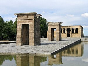
Temple of Debod
Ancient Nubian temple
Distance: Approx. 527 meters
Latitude and longitude: 40.42405278,-3.71777778
The Temple of Debod (Spanish: Templo de Debod) is an ancient Nubian temple currently located in Madrid, Spain. The temple was originally erected in the early 2nd century BC at 15 km (9.3 mi) south of Aswan, Egypt. The Egyptian government donated the temple to Spain in 1968 as a sign of gratitude for their participation in the International Campaign to Save the Monuments of Nubia.
ICAI School of Engineering
Distance: Approx. 594 meters
Latitude and longitude: 40.4299,-3.7127
ICAI School of Engineering (Escuela Técnica Superior de Ingeniería - ICAI in Spanish) is the school of engineering of the Comillas Pontifical University, located in Madrid, Spain. ICAI is the acronym by which the Instituto Católico de Artes e Industrias (Catholic Institute for Arts and Industry in English) is known. It is the name of the school even before it joined the Comillas Pontifical University in 1978.

Parque del Oeste
Public space in Madrid
Distance: Approx. 397 meters
Latitude and longitude: 40.42833333,-3.72416667
The Parque del Oeste (in English: Western Park) is a park of the city of Madrid (Spain) situated between the Autovía A-6, the Ciudad Universitaria de Madrid and the district of Moncloa. Before the 20th century, the land that the park currently occupies was the main landfill of the city. The park is the initiative of Alberto Aguilera, the mayor of the city at the beginning of the 20th century, who in 1906 requested the layout of a place for walking and relaxation by landscape artist Celedonio Rodrígáñez.

Liria Palace
Building in Madrid, Spain
Distance: Approx. 610 meters
Latitude and longitude: 40.4277,-3.7124
The Liria Palace (Spanish: Palacio de Liria) is a neoclassical palace in Madrid, Spain. It is the Madrid residence of the Dukes of Alba.
Siege of the Montaña Barracks
Siege in Madrid at the start of the Spanish Civil War
Distance: Approx. 532 meters
Latitude and longitude: 40.42403333,-3.71764444
The siege of the Montaña Barracks (Spanish: Sitio del Cuartel de la Montaña) was the two-day siege which marked the initial failure of the July 1936 uprising against the Second Spanish Republic in Madrid, on 18–20 July 1936, at the start of the Spanish Civil War. The bulk of the security forces in Madrid remained loyal to the government, and supported by workers' militias, crushed the uprising.

Ventura Rodríguez (Madrid Metro)
Madrid Metro station
Distance: Approx. 543 meters
Latitude and longitude: 40.4270848,-3.7134076
Ventura Rodríguez [benˈtuɾa roˈðɾiɣeθ] is a station on Line 3 of the Madrid Metro. It is located in fare Zone A. Its name is taken from the Calle de Ventura Rodríguez, which is named for the architect and artist Ventura Rodríguez (1717–1785).

Argüelles (Madrid Metro)
Madrid Metro station
Distance: Approx. 377 meters
Latitude and longitude: 40.4306636,-3.7159686
Argüelles [aɾˈɣweʝes] is a station on Line 3, Line 4, and Line 6 of the Madrid Metro in Madrid, Spain. It is located underneath the intersection of Princesa and Marqués de Urquijo streets, between the districts of Moncloa-Aravaca and Chamberí, in fare Zone A. The station is named after the neighborhood of Argüelles, which is in turn named after the 19th century Spanish politician Agustín Argüelles.

Argüelles (Madrid)
City neighborhood in Madrid, Community of Madrid, Spain
Distance: Approx. 172 meters
Latitude and longitude: 40.42777778,-3.71777778
Argüelles is an administrative neighborhood (barrio) of Madrid belonging to the district of Moncloa-Aravaca. As of 1 July 2019, it had a population of 24,257 inhabitants. It is 0,755758 km2 in total area.

Nebrija University
Private university in Madrid, Spain
Distance: Approx. 558 meters
Latitude and longitude: 40.42926,-3.71297
Nebrija University is a private university based in Madrid, Spain, named after Antonio de Nebrija. It has operated since 1995, and is headquartered in the Nebija-Princesa building in Madrid.
Cárcel Modelo massacre
Distance: Approx. 551 meters
Latitude and longitude: 40.43352683,-3.720079
The Cárcel Modelo massacre was the execution of roughly 30 politicians and soldiers by anarchist militiamen who occupied a Madrid prison on 22 August 1936, in the opening months of the Spanish Civil War. After defeating the 1936 military coup attempt, the Spanish government imprisoned some of the uprising's suspected political and military supporters at the Cárcel Modelo Prison in Madrid. After rumours that the prisoners were escaping, an angry crowd formed outside the prison's gates demanding the execution of the "fascists".

Casa de las Flores
Building in Chamberí, Madrid, Spain
Distance: Approx. 507 meters
Latitude and longitude: 40.4324,-3.7162
The Casa de las Flores is a block of flats in the Chamberí district of Madrid, designed by Secundino Zuazo in 1931. The distribution of spaces with its central landscaped corridor has provided a model for architecture students studying the fifties and sixties. It is located on the corner of Calle de la Princesa (Hilarión Eslava, Rodríguez San Pedro, Gaztambide and Meléndez Valdés streets), and has balconies decorated with flower boxes, from which the name of the building is derived.
Weather in this IP's area
haze
6 Celsius
2 Celsius
5 Celsius
6 Celsius
1017 hPa
64 %
1017 hPa
940 hPa
2800 meters
5.14 m/s
40 degree
07:59:07
17:59:29

