Country:
Region:
City:
Latitude and Longitude:
Time Zone:
Postal Code:
IP information under different IP Channel
ip-api
Country
Region
City
ASN
Time Zone
ISP
Blacklist
Proxy
Latitude
Longitude
Postal
Route
Luminati
Country
Region
nw
City
oberhausen
ASN
Time Zone
Europe/Berlin
ISP
Finanz Informatik Technologie Service GmbH & Co. KG
Latitude
Longitude
Postal
IPinfo
Country
Region
City
ASN
Time Zone
ISP
Blacklist
Proxy
Latitude
Longitude
Postal
Route
db-ip
Country
Region
City
ASN
Time Zone
ISP
Blacklist
Proxy
Latitude
Longitude
Postal
Route
ipdata
Country
Region
City
ASN
Time Zone
ISP
Blacklist
Proxy
Latitude
Longitude
Postal
Route
Popular places and events near this IP address

Vaterstetten
Municipality in Bavaria, Germany
Distance: Approx. 3078 meters
Latitude and longitude: 48.105,11.77055556
Vaterstetten is a municipality in the Upper Bavarian district of Ebersberg. It lies east of Munich and is the district's biggest community. Vaterstetten is on the outskirts of Munich, roughly twenty minutes by S-Bahn from Marienplatz.
Solalinden
Distance: Approx. 1927 meters
Latitude and longitude: 48.1,11.71666667
Solalinden is a small village south-east of Munich, Germany. The village is a part of Putzbrunn Gemeinde, i.e. municipality.

Haar, Bavaria
Municipality in Bavaria, Germany
Distance: Approx. 1587 meters
Latitude and longitude: 48.1,11.73333333
Haar (German pronunciation: [ˈhaːɐ̯]) is a municipality in the district of Munich, in Bavaria, Germany. It is 12 km east of Munich (centre). As of 2017 it had a population of more than 20,000.
Messestadt Ost station
Station of the Munich U-Bahn
Distance: Approx. 2972 meters
Latitude and longitude: 48.13333333,11.70361111
Messestadt Ost is a Munich U-Bahn station on line U2.

Bauma (trade fair)
Distance: Approx. 3406 meters
Latitude and longitude: 48.1355,11.6986
The bauma (International Trade Fair for Construction Machinery, Building Material Machines, Mining Machines, Construction Vehicles and Construction Equipment) is the world's largest trade fair in the construction industry. The trade fair, which can be visited by anyone, is held every three years on the grounds of the Neue Messe München and lasts for seven days. Its organizer is Messe München.

Bundesautobahn 99
Federal motorway in Germany
Distance: Approx. 2844 meters
Latitude and longitude: 48.0903,11.745
Bundesautobahn 99 (translates from German as Federal Motorway 99, short form Autobahn 99, abbreviated as BAB 99 or A 99) is an autobahn in southern Germany. It is the Munich outer ring road.

Haus der Gegenwart
Distance: Approx. 2976 meters
Latitude and longitude: 48.12833333,11.6975
Haus der Gegenwart is located in Munich, Bavaria, Germany.

Riemer See
Lake in Munich, Bavaria, Germany
Distance: Approx. 2180 meters
Latitude and longitude: 48.12333333,11.70555556
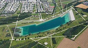
The Riemer See lake in Riemer Park, was a part of the Bundesgartenschau 2005, and is an artificial lake in Munich, Bavaria, Germany. The Riemer Park which is located in the new Messestadt Riem, was planned by the French landscape architect Gilles Vexlard. The Riemer See is located in the most eastern part of the park.
1970 Munich bus attack
Terrorist incident at a German airport
Distance: Approx. 2626 meters
Latitude and longitude: 48.136,11.718
On 10 February 1970, a bus carrying passengers to an El Al airplane at the Munich-Riem Airport, West Germany was attacked by terrorists. One person was killed and 23 were wounded in the attack.
Haar station
Railway station in Germany
Distance: Approx. 357 meters
Latitude and longitude: 48.111,11.7312
Haar station (German: Bahnhof Haar) is a railway station in the municipality of Haar, located in the Munich district in Bavaria, Germany.
Gronsdorf station
Railway station in Haar, Germany
Distance: Approx. 2451 meters
Latitude and longitude: 48.1183,11.6991
Gronsdorf station (German: Haltepunkt Gronsdorf) is a railway station in the municipality of Haar, located in the Munich district in Bavaria, Germany. The Gronsdorf stop, located on the city border between Munich and the municipality of Haar, was subsequently established on 1 May 1897. It is located between the Munich district of Waldtrudering and the Haar settlement of Gronsdorf, after which it is named.
Vaterstetten station
Railway station in Vaterstetten, Germany
Distance: Approx. 2705 meters
Latitude and longitude: 48.104093,11.76459
Vaterstetten station (German: Haltepunkt Vaterstetten) is a railway station in the municipality of Vaterstetten, located in the Ebersberg district in Bavaria, Germany. The halt of Vaterstetten was opened on 1 May 1897. Today, the station is served only by the S-Bahn.
Weather in this IP's area
broken clouds
8 Celsius
8 Celsius
7 Celsius
10 Celsius
1029 hPa
87 %
1029 hPa
964 hPa
10000 meters
1.34 m/s
2.68 m/s
29 degree
83 %
07:01:40
16:51:32


