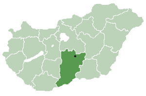
185.152.180.230 - IP Lookup: Free IP Address Lookup, Postal Code Lookup, IP Location Lookup, IP ASN, Public IP
Country:
Region:
City:
Location:
Time Zone:
Postal Code:
IP information under different IP Channel
ip-api
Country
Region
City
ASN
Time Zone
ISP
Blacklist
Proxy
Latitude
Longitude
Postal
Route
Luminati
Country
Region
jn
City
torokszentmiklos
ASN
Time Zone
Europe/Budapest
ISP
WaveCom Informatikai Kft.
Latitude
Longitude
Postal
IPinfo
Country
Region
City
ASN
Time Zone
ISP
Blacklist
Proxy
Latitude
Longitude
Postal
Route
IP2Location
185.152.180.230Country
Region
jasz-nagykun-szolnok
City
cserkeszolo
Time Zone
Europe/Budapest
ISP
Language
User-Agent
Latitude
Longitude
Postal
db-ip
Country
Region
City
ASN
Time Zone
ISP
Blacklist
Proxy
Latitude
Longitude
Postal
Route
ipdata
Country
Region
City
ASN
Time Zone
ISP
Blacklist
Proxy
Latitude
Longitude
Postal
Route
Popular places and events near this IP address
Nagyrév
Village in Jász-Nagykun-Szolnok, Hungary
Distance: Approx. 9226 meters
Latitude and longitude: 46.94194444,20.14916667
Nagyrév is a village in Jasz-Nagykun-Szolnok, central Hungary. It was the location of the Nagyrév culture. Between 1914 and 1929, a large group of female villagers calling themselves "the Angel Makers of Nagyrév" systematically poisoned to death an estimated forty people.

Nagykunság
Historical Cuman region of central Hungary
Distance: Approx. 7642 meters
Latitude and longitude: 46.91666667,20.25
Nagykunság ("Greater Cumania", Latin: Cumania Major) is a historical and geographical region in Hungary situated in the current Jász-Nagykun-Szolnok county between Szolnok and Debrecen. Like other historical European regions called Cumania, it is named for the Cumans, a nomadic tribe of pagan Kipchaks that settled the area. Its territory is 1,196 km2.

Kunszentmárton
Town in Jász-Nagykun-Szolnok, Hungary
Distance: Approx. 8016 meters
Latitude and longitude: 46.84111111,20.28722222
Kunszentmárton is a small town of the county of Jász-Nagykun-Szolnok, central Hungary.

Tiszaug
Place in Bács-Kiskun, Hungary
Distance: Approx. 9277 meters
Latitude and longitude: 46.85,20.06666667
Tiszaug is a village in Bács-Kiskun county, in the Southern Great Plain region of southern Hungary.
Tiszasas
Village in Jász-Nagykun-Szolnok, Hungary
Distance: Approx. 9292 meters
Latitude and longitude: 46.82305556,20.08
Tiszasas is a village in Jász-Nagykun-Szolnok county, in the Northern Great Plain region of central Hungary. It is near the river Tisza, where people like to go fishing. It has a church near the river.
Cserkeszőlő
Village in Jász-Nagykun-Szolnok, Hungary
Distance: Approx. 1414 meters
Latitude and longitude: 46.86388889,20.20555556
Cserkeszőlő is a village in Jász-Nagykun-Szolnok county, in the Northern Great Plain region of central Hungary. Cserkeszőlő is a dynamically developing bath resort in Jász-Nagykun-Szolnok county, in the south part of Northern Great Plains Region. The village lies in the Tiszazug microregion, in the natural environment bordered by the rivers Körös and Tisza.
Csépa
Village in Jász-Nagykun-Szolnok, Hungary
Distance: Approx. 7597 meters
Latitude and longitude: 46.80666667,20.13111111
Csépa is a village in Jász-Nagykun-Szolnok county, in the Northern Great Plain region of central Hungary.
Tiszainoka
Village in Jász-Nagykun-Szolnok, Hungary
Distance: Approx. 5256 meters
Latitude and longitude: 46.90388889,20.15194444
Tiszainoka is a village in Jász-Nagykun-Szolnok county, in the Northern Great Plain region of central Hungary.

Szelevény
Village in Jász-Nagykun-Szolnok, Hungary
Distance: Approx. 6903 meters
Latitude and longitude: 46.80194444,20.20111111
Szelevény is a village in Jász-Nagykun-Szolnok county, in the Northern Great Plain region of central Hungary.
Tiszakürt
Village in Jász-Nagykun-Szolnok, Hungary
Distance: Approx. 5216 meters
Latitude and longitude: 46.88472222,20.12611111
Tiszakürt is a village in Jász-Nagykun-Szolnok county, in the Northern Great Plain region of central Hungary.

Kunszentmárton District
Districts of Hungary in Jász-Nagykun-Szolnok
Distance: Approx. 6306 meters
Latitude and longitude: 46.9,20.25
Kunszentmárton (Hungarian: Kunszentmártoni járás) is a district in southern part of Jász-Nagykun-Szolnok County. Kunszentmárton is also the name of the town where the district seat is found. The district is located in the Northern Great Plain Statistical Region.
Battle of Cibakháza
Distance: Approx. 8860 meters
Latitude and longitude: 46.94222222,20.17305556
The Battle of Cibakháza was one of the several battles for the bridge over the Tisza river from Cibakháza in the Hungarian war of Independence of 1848-1849, fought on 24 February 1849 between the Hungarian troops defending the bridge led by Major Károly Leiningen-Westerburg and the troops of the Austrian Empire, led by Major General Ferenc Ottinger, who were trying to capture and destroy it, in order to prevent the Hungarian incursions on the right bank of the river. The Hungarians defeated the Austrians, forcing Ottinger to retreat. The Hungarians managed to keep the bridge, which continued to remain a danger for the Austrian possessions on the right baank of the Tisza.
Weather in this IP's area
broken clouds
6 Celsius
2 Celsius
6 Celsius
6 Celsius
1013 hPa
96 %
1013 hPa
1003 hPa
10000 meters
4.63 m/s
12.01 m/s
185 degree
67 %