Country:
 France
Region:
City:
Latitude and Longitude:
Time Zone:
Postal Code:
IP information under different IP Channel
ip-api
Country
Region
City
ASN
Time Zone
ISP
Blacklist
Proxy
Latitude
Longitude
Postal
Route
IPinfo
Country
Region
City
ASN
Time Zone
ISP
Blacklist
Proxy
Latitude
Longitude
Postal
Route
MaxMind
Country
Region
City
ASN
Time Zone
ISP
Blacklist
Proxy
Latitude
Longitude
Postal
Route
Luminati
Country
FRASN
Time Zone
Europe/Paris
ISP
Groupe convergence.com SAS
Latitude
Longitude
Postal
db-ip
Country
Region
City
ASN
Time Zone
ISP
Blacklist
Proxy
Latitude
Longitude
Postal
Route
ipdata
Country
Region
City
ASN
Time Zone
ISP
Blacklist
Proxy
Latitude
Longitude
Postal
Route
Popular places and events near this IP address

Albi
Prefecture and commune in Occitania, France
Distance: Approx. 163 meters
Latitude and longitude: 43.9289,2.1464
Albi (French pronunciation: [albi] ; Occitan: Albi [ˈalβi]) is a commune in southern France. It is the prefecture of the Tarn department, on the river Tarn, 85 km northeast of Toulouse. Its inhabitants are called Albigensians (French: Albigeois, Albigeoise(s), Occitan: albigés -esa(s)).

Arrondissement of Albi
Arrondissement in Occitania, France
Distance: Approx. 1240 meters
Latitude and longitude: 43.93333333,2.13333333
The arrondissement of Albi is an arrondissement of France in the Tarn department in the Occitanie region. Its INSEE code is 811 and its capital city is Albi. It has 163 communes.
Stadium Municipal d'Albi
Multi-purpose stadium in Albi, France
Distance: Approx. 1641 meters
Latitude and longitude: 43.92333333,2.16638889
The Stadium Municipal d'Albi is a multi-purpose stadium in Albi, France. It is currently used for rugby league as the home ground of Racing Club Albi XIII and rugby union as the home of SC Albi. After an expansion project completed in 2007, the stadium holds 13,000 with 8,000 seated.

Albi Cathedral
UNESCO World Heritage Site
Distance: Approx. 431 meters
Latitude and longitude: 43.928492,2.142945
The Cathedral of Saint Cecilia of Albi (French: Cathédrale Sainte-Cécile d'Albi), also known as Albi Cathedral, is the seat of the Catholic Archbishop of Albi. First built in the aftermath of the Albigensian Crusade, the grim exterior resembles a fortress, but the interior is lavishly decorated with art and sculpture, a very ornate choir screen, and walls in bright blues and golds, in the Toulousian or Southern French Gothic style. It was begun in 1282 and was under construction for 200 years.
Jean-François Champollion University Center for Teaching and Research
French university, in the Academy of Toulouse
Distance: Approx. 1537 meters
Latitude and longitude: 43.9182,2.1376
The National University Institute Jean-Francois Champollion (Institut National Universitaire Jean-François Champollion), formerly known as Jean-Francois Champollion University Center for Teaching and Research (Centre universitaire de formation et de recherche Jean-François Champollion) is a French university, in the Academy of Toulouse. Founded in 2002 on the site of the former military barracks of the Caserne Lapérouse in Albi, France, site of its main campus and administrative offices, it also has campuses in Rodez and Castres. With fewer than 4000 students it is one of France's smallest universities, a fact which has often been credited with its high rate of student success.

Albi-Ville station
Railway station in Albi, France
Distance: Approx. 1170 meters
Latitude and longitude: 43.9225,2.1375
Albi-Ville is a railway station in Albi, Occitanie, which is the southernmost administrative region of France. The station is located on the Toulouse–Rodez railway line.
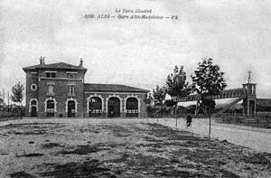
Albi-Madeleine station
Railway station in Albi, France
Distance: Approx. 1034 meters
Latitude and longitude: 43.93777778,2.14138889
Albi-Madeleine station (French: Gare d'Albi-Madeleine) is a railway station in Albi, Occitanie, France. The original station opened in 1857 and the current station opened in 1899. Located on the Toulouse to Rodez railway line, the station is served by Intercités de Nuit (night train) and TER (local) services.
Musée Toulouse-Lautrec
Art museum in Albi, southern France
Distance: Approx. 403 meters
Latitude and longitude: 43.92916667,2.14305556
The Musée Toulouse-Lautrec is an art museum in Albi, southern France, dedicated mainly to the work of the painter Henri de Toulouse-Lautrec who was born in Albi. The 13th-century building was originally the Bishop's Palace of Albi Cathedral, next to it. It is part of the UNESCO World Heritage Site that includes the cathedral.
Canton of Albi-1
Distance: Approx. 162 meters
Latitude and longitude: 43.93,2.15
The canton of Albi-1 is an administrative division of the Tarn department, southern France. It was created at the French canton reorganisation which came into effect in March 2015. Its seat is in Albi.
Canton of Albi-2
Distance: Approx. 1103 meters
Latitude and longitude: 43.92,2.15
The canton of Albi-2 is an administrative division of the Tarn department, southern France. It was created at the French canton reorganisation which came into effect in March 2015. Its seat is in Albi.
Canton of Albi-4
Distance: Approx. 1304 meters
Latitude and longitude: 43.94,2.14
The canton of Albi-4 is an administrative division of the Tarn department, southern France. It was created at the French canton reorganisation which came into effect in March 2015. Its seat is in Albi.

Circuit Les Planques
Motor racing road circuit in France
Distance: Approx. 1867 meters
Latitude and longitude: 43.93165556,2.17114722
Circuit Les Planques was a 9.226 km (5.733 mi) long motor racing road circuit in a triangular shape, located near Albi. The circuit was later shortened to 8.911 km (5.537 mi) in 1934, and again to 2.991 km (1.859 mi) in 1954.
Weather in this IP's area
overcast clouds
18 Celsius
18 Celsius
18 Celsius
18 Celsius
1016 hPa
71 %
1016 hPa
995 hPa
10000 meters
4.6 m/s
11.2 m/s
116 degree
98 %
07:37:44
19:51:07