Country:
 Netherlands
Region:
City:
Latitude and Longitude:
Time Zone:
Postal Code:
IP information under different IP Channel
ip-api
Country
Region
City
ASN
Time Zone
ISP
Blacklist
Proxy
Latitude
Longitude
Postal
Route
IPinfo
Country
Region
City
ASN
Time Zone
ISP
Blacklist
Proxy
Latitude
Longitude
Postal
Route
MaxMind
Country
Region
City
ASN
Time Zone
ISP
Blacklist
Proxy
Latitude
Longitude
Postal
Route
Luminati
Country
 US
USASN
Time Zone
America/Chicago
ISP
WIKIMEDIA
Latitude
Longitude
Postal
db-ip
Country
Region
City
ASN
Time Zone
ISP
Blacklist
Proxy
Latitude
Longitude
Postal
Route
ipdata
Country
Region
City
ASN
Time Zone
ISP
Blacklist
Proxy
Latitude
Longitude
Postal
Route
Popular places and events near this IP address

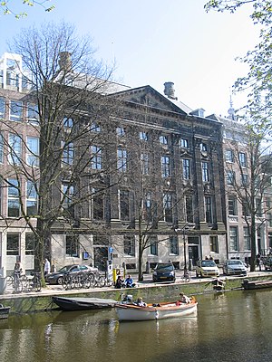
Allard Pierson Museum
Archaeological museum in Amsterdam, Netherlands
Distance: Approx. 206 meters
Latitude and longitude: 52.36894444,4.89294444
The Allard Pierson Museum is the archaeological museum of the University of Amsterdam. It is situated at the Oude Turfmarkt 127 in Amsterdam, the Netherlands. Artifacts from the ancient civilizations of ancient Egypt, the Near East, the Greek World, Etruria, and the Roman Empire are curated and exhibited in this museum.

Nes (Amsterdam)
Distance: Approx. 143 meters
Latitude and longitude: 52.37083333,4.89333333
Nes ([ˈnɛs]; sometimes called de Nes, "the Nes") is a narrow, old, street in central Amsterdam, Netherlands. It runs parallel to and to the east of Rokin, between Dam Square to the north and Grimburgwal to the south. The Dutch word nes means headland or spit (compare the English word "ness", often found as a suffix in placenames, such as Inverness).

Binnenstad, Amsterdam
Neighbourhood of Amsterdam in North Holland, Netherlands
Distance: Approx. 208 meters
Latitude and longitude: 52.372,4.896
Binnenstad (English: Inner city) is a neighborhood of Amsterdam, Netherlands located in the Centrum borough. It is divided between the Burgwallen Oude Zijde (east) and Burgwallen Nieuwe Zijde (west) areas.

Huis aan de Drie Grachten
17th C. canal house in Amsterdam
Distance: Approx. 119 meters
Latitude and longitude: 52.36916667,4.89472222
The Huis aan de Drie Grachten or Huis op de Drie Grachten ("House on Three Canals") is a 17th-century canal house in Amsterdam, at the southeastern end of the Wallen district. The name is a reference to the fact that the building faces three different Amsterdam canals. The south facade faces Grimburgwal, the west facade faces Oudezijds Voorburgwal and the east facade faces Oudezijds Achterburgwal.

Athenaeum Illustre of Amsterdam
Distance: Approx. 88 meters
Latitude and longitude: 52.36944444,4.89555556
Athenaeum Illustre, or Amsterdamse Atheneum, was a city-sponsored 'illustrious school' founded after the beeldenstorm in the old Agnieten chapel on the Oudezijds Voorburgwal 231 in Amsterdam, Netherlands. Famous scientists such as Caspar Barlaeus, Gerardus Vossius, Martinus Hortensius, Alexander de Bie, and Petrus Camper taught here.
Kloveniersburgwal, Amsterdam
Canal in Amsterdam
Distance: Approx. 199 meters
Latitude and longitude: 52.3703,4.8981
Kloveniersburgwal is an Amsterdam canal flowing south from Nieuwmarkt to the Amstel River on the edge of the medieval city, lying east of the dam in the centre of Amsterdam.
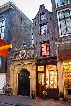
Smallest house in Amsterdam
Distance: Approx. 205 meters
Latitude and longitude: 52.3711,4.8978
The smallest house in Amsterdam is located at Oude Hoogstraat 22 in the old city center of Amsterdam, next to the Oost-Indisch Huis and the gate to the Walloon Church. The house, by some called the "Smallest house of Europe", is 2.02 meters (6 feet 8 inches) wide and 5 meters (16 feet 5 inches) deep. With its distinctive spout gable, this house represents a miniature version of a typical Amsterdam canal house.

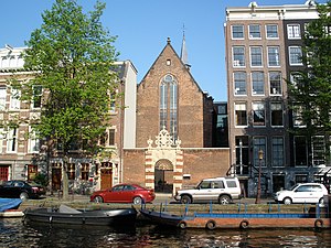
Walloon Church, Amsterdam
Church in Netherlands
Distance: Approx. 156 meters
Latitude and longitude: 52.37083333,4.89722222
The Walloon Church (Dutch: Waalse Kerk; French: Église Wallonne) is a Protestant church building in Amsterdam, along the southern stretch of the Oudezijds Achterburgwal canal. The building dates to the late 15th century and has been in use as a Walloon church since 1586. The church was also known as the Franse Kerk ("French Church"), Walenkerk ("Walloons' Church"), Oude Walenkerk ("Old Walloons' Church"), or Oude Waalse Kerk ("Old Walloon Church").

Stadsbank van Lening, Amsterdam
Not-for-profit city Bank van Lening in Amsterdam, Netherlands
Distance: Approx. 75 meters
Latitude and longitude: 52.37048889,4.89416944
The Stadsbank van Lening (Dutch pronunciation: [ˈstɑtsbɑŋk fɑn ˈleːnɪŋ]) is a not-for-profit city Bank van Lening dating from 1614 on the Oudezijds Voorburgwal in Amsterdam, Netherlands. It is the oldest credit distributor in Amsterdam and today has about 85 employees working here and in offices on the Albert Cuypstraat, Bijlmerplein and Osdorpplein.
Agnietenkapel
Church in Amsterdam, Netherlands
Distance: Approx. 88 meters
Latitude and longitude: 52.36944444,4.89555556
The Agnietenkapel (Chapel of the Convent of Saint Agnes) is a 15th-century Gothic chapel in Amsterdam. It is the birthplace of the University of Amsterdam and still in use for doctoral dissertations and other university ceremonies, as well as academic events such as lectures and symposiums. The building has held rijksmonument status since 1970.

Rokin metro station
Metro station in Amsterdam, Netherlands
Distance: Approx. 192 meters
Latitude and longitude: 52.37111111,4.89277778
Rokin metro station is an Amsterdam Metro station on Line 52, the fifth and newest metro line in Amsterdam which connects the Amsterdam-Noord (north) borough to the Amsterdam-Zuid (south) via Amsterdam Centraal. It began service in July 2018 and is under the Rokin canal in Amsterdam, Netherlands. Overground, this metro station serves as a connection to the tram lines 4, 14 and 24 as well as the night buses N85, N86, N87 & N88.

Grimburgwal
Canal in Amsterdam
Distance: Approx. 156 meters
Latitude and longitude: 52.369167,4.893611
The Grimburgwal is a small canal and street in the center of Amsterdam.
Weather in this IP's area
light rain
14 Celsius
14 Celsius
13 Celsius
15 Celsius
998 hPa
86 %
998 hPa
998 hPa
10000 meters
4.12 m/s
80 degree
75 %
07:53:44
19:01:39