Country:
 France
Region:
City:
Latitude and Longitude:
Time Zone:
Postal Code:
IP information under different IP Channel
ip-api
Country
Region
City
ASN
Time Zone
ISP
Blacklist
Proxy
Latitude
Longitude
Postal
Route
IPinfo
Country
Region
City
ASN
Time Zone
ISP
Blacklist
Proxy
Latitude
Longitude
Postal
Route
MaxMind
Country
Region
City
ASN
Time Zone
ISP
Blacklist
Proxy
Latitude
Longitude
Postal
Route
Luminati
Country
FRRegion
ara
City
bourgsaintmaurice
ASN
Time Zone
Europe/Paris
ISP
Neptune Internet Services SAS
Latitude
Longitude
Postal
db-ip
Country
Region
City
ASN
Time Zone
ISP
Blacklist
Proxy
Latitude
Longitude
Postal
Route
ipdata
Country
Region
City
ASN
Time Zone
ISP
Blacklist
Proxy
Latitude
Longitude
Postal
Route
Popular places and events near this IP address
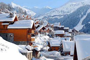
Méribel
Ski resort in France
Distance: Approx. 2036 meters
Latitude and longitude: 45.39673056,6.56626944
Méribel (French pronunciation: [meʁibɛl]) is a ski resort in the Tarentaise Valley in the French Alps. Méribel refers to three neighbouring villages in the Les Allues commune of the Savoie department of France, near the town of Moûtiers (45.401°N 6.5655°E / 45.401; 6.5655), called Méribel Centre, Méribel-Mottaret and Méribel Village. The villages are within Vanoise National Park and a part of the Les Trois Vallées interlinked ski system.

Les Allues
Commune in Auvergne-Rhône-Alpes, France
Distance: Approx. 1969 meters
Latitude and longitude: 45.4317,6.5567
Les Allues (French pronunciation: [le.z‿aly]; Savoyard Arpitan: Los Alués) is a commune in the Savoie department in the Auvergne-Rhône-Alpes region in Southeastern France. In 2019, it had a population of 1,860. Les Allues is best known for containing the Méribel ski resort and its surrounding Méribel les Allues area; the southernmost part of the commune is covered by Vanoise National Park.
Méribel Ice Palace
Distance: Approx. 2378 meters
Latitude and longitude: 45.39364444,6.56588333
Méribel Ice Palace is an indoor ice hockey arena in Méribel, France. It was built in 1991 and held 8,000 people when it opened. The ice hockey games from the 1992 Winter Olympics were held at this arena.

Brides-les-Bains
Commune in Auvergne-Rhône-Alpes, France
Distance: Approx. 4268 meters
Latitude and longitude: 45.4533,6.5675
Brides-les-Bains (French pronunciation: [bʁid le bɛ̃]) is a commune in the Savoie department in the Auvergne-Rhône-Alpes region in south-eastern France. It was an Olympic Village for the 1992 Winter Olympics, based in Albertville, France. There is easy accessibility via Eurostar direct from London and there is a cable-car link direct to the ski slopes at Méribel, a major resort eight miles (13 km) away.

La Tania
Distance: Approx. 3006 meters
Latitude and longitude: 45.43166667,6.59527778
La Tania is a ski resort situated in the Courchevel area of Les Trois Vallees, located at an elevation of 1400 meters. It was developed for the Albertville Olympics of 1992 and is approximately a 25-minute drive from Moûtiers.

La Perrière, Savoie
Part of Courchevel in Auvergne-Rhône-Alpes, France
Distance: Approx. 4127 meters
Latitude and longitude: 45.4458,6.5944
La Perrière (French pronunciation: [la pɛʁjɛʁ] ; Arpitan: La Pèrîr) is a former commune in the Savoie department in the Auvergne-Rhône-Alpes region in south-eastern France. On 1 January 2017, it was merged into the new commune Courchevel.
Refuge de la Traie
Distance: Approx. 2964 meters
Latitude and longitude: 45.42805556,6.53194444
Refuge de la Traye or Traie is a refuge in the Alps. Created in 1982, it closes to the autumn of 2017; it is completely renovated and extended in 2019 to accommodate the first high-end refuge in the French Alps.

Méribel Altiport
Airport in Les Allues
Distance: Approx. 1285 meters
Latitude and longitude: 45.4075,6.5775
Méribel Altiport (French: Altiport de Méribel) (IATA: MFX, ICAO: LFKX), is an altiport in Les Allues, a commune in Savoie, France. It is used for the practice of leisure and tourism activities (light aviation and helicopter). It is an altiport (an airfield located in the mountains with the runway at a significant slope, i.e.

Tremplin du Praz
Ski jumping hill at Le Praz, France
Distance: Approx. 4411 meters
Latitude and longitude: 45.4314,6.61639
The Tremplin du Praz is a ski jumping hill at Le Praz in Courchevel, France. The complex consists of four hills: a large hill with construction point of K125 (HS132), a normal hill at K90 (HS96), and two training hills at K60 and K25. The complex also has a cross-country skiing stadium used for Nordic combined.

Le Praz
Village in France
Distance: Approx. 4365 meters
Latitude and longitude: 45.431,6.616
Le Praz is a village located on a plateau at the foot of the forest in Courchevel, Savoie, France, at the foot of Dent du Villard and Grand Bec. It features the ski jumping hill Tremplin du Praz, built for the 1992 Winter Olympics and used annually in the summer FIS Ski Jumping Grand Prix.
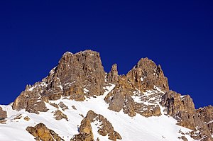
Dent de Burgin
Mountain near the Meribel resort in Savoie, France
Distance: Approx. 4330 meters
Latitude and longitude: 45.389,6.6062
Dent de Burgin is a mountain near the Meribel resort in Savoie, France. It lies in the Vanoise range. It has an altitude of 2739 meters above sea level.

Roc de Fer
Distance: Approx. 2036 meters
Latitude and longitude: 45.396731,6.566269
Roc de Fer (French: "iron rock") is a downhill Alpine skiing course in Méribel, France, which is part of the large interlinked ski area known as Les Trois Vallées in the Savoie department of France, near Mont Blanc. The course was originally created for the 1992 Winter Olympics and has since played host to the World Cup season finals in 2015 and 2022 and the 2023 FIS World Ski Championships, the latter two in conjunction with the L’Éclipse course in the neighboring town of Courchevel. Roc de Fer is considered venue for 2030 Winter Olympics Alpine skiing events.
Weather in this IP's area
light rain
7 Celsius
6 Celsius
6 Celsius
9 Celsius
1014 hPa
95 %
1014 hPa
852 hPa
6207 meters
2.51 m/s
3.13 m/s
99 degree
100 %
07:54:01
18:43:19