Country:
 Norway
Region:
City:
Latitude and Longitude:
Time Zone:
Postal Code:
IP information under different IP Channel
ip-api
Country
Region
City
ASN
Time Zone
ISP
Blacklist
Proxy
Latitude
Longitude
Postal
Route
IPinfo
Country
Region
City
ASN
Time Zone
ISP
Blacklist
Proxy
Latitude
Longitude
Postal
Route
MaxMind
Country
Region
City
ASN
Time Zone
ISP
Blacklist
Proxy
Latitude
Longitude
Postal
Route
Luminati
Country
NOASN
Time Zone
Europe/Oslo
ISP
Globalconnect As
Latitude
Longitude
Postal
db-ip
Country
Region
City
ASN
Time Zone
ISP
Blacklist
Proxy
Latitude
Longitude
Postal
Route
ipdata
Country
Region
City
ASN
Time Zone
ISP
Blacklist
Proxy
Latitude
Longitude
Postal
Route
Popular places and events near this IP address

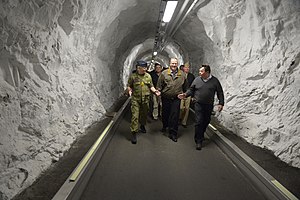
Joint Warfare Centre
NATO military command unit
Distance: Approx. 1772 meters
Latitude and longitude: 58.9075,5.72166667
The Joint Warfare Centre (JWC) is a NATO establishment headquartered in Stavanger, Norway. It was established at Jåttå on 23 October 2003 as a subordinate command of Headquarters Supreme Allied Commander Transformation (HQ SACT). The purpose of this was to have a command with responsibility for training and exercise of the NATO headquarters.

Equinor
Norwegian energy company
Distance: Approx. 1163 meters
Latitude and longitude: 58.8918,5.71745
Equinor ASA (formerly Statoil and StatoilHydro) is a Norwegian state-owned multinational energy company headquartered in Stavanger, Norway. It is primarily a petroleum company operating in 36 countries with additional investments in renewable energy. In the 2020 Forbes Global 2000, Equinor was ranked as the 169th-largest public company in the world.

Stavanger Airport, Forus
Airport in Rogaland, Norway
Distance: Approx. 667 meters
Latitude and longitude: 58.89222222,5.7075
Stavanger Airport, Forus (Norwegian: Stavanger lufthavn, Forus: ICAO: ENFO) is a former airport located at Forus in the intersection of the municipalities of Stavanger, Sola and Sandnes. It was built as a military air base by the Luftwaffe following the German occupation of Norway in April 1940. It was gradually expanded so that it by 1943 consisted of three runways, the longest 1,950 meters (6,400 ft).
Stokka, Sandnes
Distance: Approx. 1833 meters
Latitude and longitude: 58.88305556,5.71777778
Stokka is a neighborhood in the borough of Lura in the northwestern corner of the city of Sandnes which lies in the far western edge of the large Sandnes municipality in Rogaland county, Norway. Stokka is bordered on the south by the borough of Malmheim og Soma, to the east by the urban part of the borough of Lura, to the north by Forus in the neighboring city of Stavanger, and to the west by Sola municipality. Large parts of the area are industrialised, with the area north of the road Løwenstrasse used as the headquarters of Forus Næringspark.
British International School of Stavanger
Distance: Approx. 1959 meters
Latitude and longitude: 58.8974,5.7334
The British International School of Stavanger is an international school in Stavanger, Norway. It was founded in 1977. The school currently caters to approximately 500 pupils from over 50 different nationalities, from 18 months of age up to the age of 19.
Gausel
Norwegian neighborhood in Stavanger
Distance: Approx. 391 meters
Latitude and longitude: 58.9,5.7
Gausel is a neighborhood (delområde) in the city of Stavanger which lies in the southwestern part of the large municipality of Stavanger in Rogaland county, Norway. It is located in the borough of Hinna between the neighborhoods of Jåttå, Godeset, and Forus and the Gandsfjorden.
Stokkavatnet (Forus)
Former lake in Stavanger, Norway
Distance: Approx. 290 meters
Latitude and longitude: 58.8944,5.69639
Stokkavatnet is a former lake that was located at Forus in Stavanger, Norway, between the two fjords Hafrsfjord and Gandsfjord. The lake was among the largest at the Northern Jæren district, with an area of about 4 km2. It was surrounded by considerable areas of marsh land, and was known for a rich birdlife.
Godeset
Distance: Approx. 826 meters
Latitude and longitude: 58.8975,5.71361111
Godeset is a neighborhood (delområde) in the city of Stavanger which lies in the southwestern part of the large municipality of Stavanger in Rogaland county, Norway. It is located in the borough of Hinna, between Gausel and Forus. In Godeset, one can find a number of small industries as well as service industries.
Norwegian Joint Headquarters
Military unit
Distance: Approx. 1796 meters
Latitude and longitude: 58.9075,5.72222222
The Norwegian Joint Headquarters, NJHQ (Norwegian: Forsvarets operative hovedkvarter, FOH) is the Norwegian Armed Forces operational commando-center. It is located at Reitan outside Bodø, where during the Cold War NATO's Allied Command North Norway was based. The current organization was created on 1 August 2009, replacing a former joint commando center in Stavanger, which merged with the Northern Norway Command.
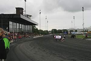
Forus Travbane
Distance: Approx. 1588 meters
Latitude and longitude: 58.89083333,5.72472222
Forus Travbane is a harness racing track located at Forus in Stavanger, Norway. The course is 950 meters (3,120 ft). Owned by Norwegian Trotting Association, its tote betting is handled by Norsk Rikstoto.
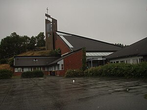
Gausel Church
Church in Rogaland, Norway
Distance: Approx. 1352 meters
Latitude and longitude: 58.89864,5.722519
Gausel Church (Norwegian: Gausel kirke) is a parish church of the Church of Norway in the southern part of the large Stavanger Municipality in Rogaland county, Norway. It is located in the Gausel neighborhood in the borough of Hinna in the southern part of the city of Stavanger. It is the church for the Gausel parish which is part of the Ytre Stavanger prosti (deanery) in the Diocese of Stavanger.
Allied Forces South Norway
Military unit
Distance: Approx. 1630 meters
Latitude and longitude: 58.9056,5.7216
Allied Forces South Norway (SONOR) was a NATO command tasked with the defense of Southern Norway. SONOR's area of responsibility included all of Norway with the adjacent sea territory excluding the three northernmost counties of Norway, which were under Allied Forces North Norway.
Weather in this IP's area
few clouds
10 Celsius
10 Celsius
10 Celsius
12 Celsius
1030 hPa
88 %
1030 hPa
1029 hPa
10000 meters
0.51 m/s
100 degree
20 %
07:11:20
19:52:03