185.149.17.69 - IP Lookup: Free IP Address Lookup, Postal Code Lookup, IP Location Lookup, IP ASN, Public IP
Country:
Region:
City:
Location:
Time Zone:
Postal Code:
ISP:
ASN:
language:
User-Agent:
Proxy IP:
Blacklist:
IP information under different IP Channel
ip-api
Country
Region
City
ASN
Time Zone
ISP
Blacklist
Proxy
Latitude
Longitude
Postal
Route
db-ip
Country
Region
City
ASN
Time Zone
ISP
Blacklist
Proxy
Latitude
Longitude
Postal
Route
IPinfo
Country
Region
City
ASN
Time Zone
ISP
Blacklist
Proxy
Latitude
Longitude
Postal
Route
IP2Location
185.149.17.69Country
Region
agder
City
bykle
Time Zone
Europe/Oslo
ISP
Language
User-Agent
Latitude
Longitude
Postal
ipdata
Country
Region
City
ASN
Time Zone
ISP
Blacklist
Proxy
Latitude
Longitude
Postal
Route
Popular places and events near this IP address

Botsvatn
Lake in Norway
Distance: Approx. 9042 meters
Latitude and longitude: 59.3309,7.2047
Botsvatn or Bossvatn is a lake in the municipality of Bykle in Agder county, Norway. The 14.6-kilometre (9.1 mi) long, narrow reservoir is located just to the southeast of the large lake Blåsjø and northeast of the lake Ytre Storevatnet. The lake holds water for the Brokke Hydroelectric Power Station, located in nearby Valle municipality.
Store Bjørnevatn
Lake in Valle, Aust-Agder, Norway
Distance: Approx. 9947 meters
Latitude and longitude: 59.3453,7.5317
Store Bjørnevatn is a lake in the municipality of Valle in Agder county, Norway. The lake is located in the northern part of the municipality, near the village of Rygnestad, and about 15 kilometres (9.3 mi) north of the municipal center of Valle and about 10 kilometres (6.2 mi) straight east of the village of Bykle in the neighboring municipality. The lake has an area of 2.43 square kilometres (0.94 sq mi) at an elevation of 801 metres (2,628 ft) above sea level.
Nordbygdi, Agder
Village in Southern Norway, Norway
Distance: Approx. 5641 meters
Latitude and longitude: 59.3486,7.2585
Nordbygdi is a village in the municipality of Bykle in Agder county, Norway. It is located in the Setesdalen valley along the northeastern shore of the lake, Botsvatn. The village is located about 1 kilometre (0.62 mi) west of the village of Bykle and the river Otra, and about 7 kilometres (4.3 mi) south of the lake Reinevatn.
Kvervetjønnuten
Mountain in Norway
Distance: Approx. 9295 meters
Latitude and longitude: 59.4339,7.3084
Kvervetjønnuten is a mountain in the municipality of Bykle in Agder county, Norway. The 1,417-metre (4,649 ft) tall mountain is the 16th highest mountain in Agder of all the mountains with a prominence of more than 50 metres (160 ft). The mountain sits on the southern shore of the lake Vatndalsvatnet, immediately east of the mountain Snjoheinuten, and the village of Hoslemo lies at the eastern foot of the mountain.
Snjoheinuten
Distance: Approx. 9562 meters
Latitude and longitude: 59.4225,7.255
Snjoheinuten is a mountain in the municipality of Bykle in Agder county, Norway. The 1,439-metre (4,721 ft) tall mountain is the 6th highest mountain in Agder county out of all the mountains with a prominence of more than 50 metres (160 ft). The mountain sits on the southern shore of the lake Vatndalsvatnet, just west of the mountain Kvervetjønnuten and east of the lakes Reinevatn and Store Urevatn.
Hoslemo
Village in Southern Norway, Norway
Distance: Approx. 8980 meters
Latitude and longitude: 59.4326,7.3946
Hoslemo is a village in Bykle municipality in Agder county, Norway. The village is located in the Setesdalen valley, along the river Otra and the Norwegian National Road 9. It is about 10 kilometres (6.2 mi) north of the village of Bykle and about 16 kilometres (9.9 mi) south of the village of Hovden.
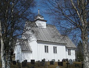
Old Bykle Church
Church in Agder, Norway
Distance: Approx. 780 meters
Latitude and longitude: 59.351923,7.344303
Old Bykle Church (Norwegian: Bykle gamle kyrkje; historically known as Bykle kyrkje) is a former parish church of the Church of Norway in Bykle Municipality in Agder county, Norway. It is located in the village of village of Bykle. It is one of the churches for the Bykle parish which is part of the Otredal prosti (deanery) in the Diocese of Agder og Telemark.
Bykle Church
Church in Agder, Norway
Distance: Approx. 863 meters
Latitude and longitude: 59.3513,7.3432
Bykle Church (Norwegian: Bykle kyrkje) is a parish church of the Church of Norway in Bykle Municipality in Agder county, Norway. It is located in the village of Bykle. It is one of the churches for the Bykle parish which is part of the Otredal prosti (deanery) in the Diocese of Agder og Telemark.

Bykle (village)
Village in Southern Norway, Norway
Distance: Approx. 6 meters
Latitude and longitude: 59.3542,7.3574
Bykle or Bykle Kyrkjebygd (locally: Kyrkjebygdi) is the administrative centre of Bykle municipality in Agder county, Norway. The village is located along the river Otra and the Norwegian National Road 9 in the southern part of the municipality. It is located about 5 kilometres (3.1 mi) east of the small village of Nordbygdi.
Weather in this IP's area
overcast clouds
-4 Celsius
-8 Celsius
-4 Celsius
-4 Celsius
1000 hPa
96 %
1000 hPa
879 hPa
1770 meters
3.29 m/s
5.37 m/s
166 degree
98 %

