Country:
 Netherlands
Region:
City:
Latitude and Longitude:
Time Zone:
Postal Code:
IP information under different IP Channel
ip-api
Country
Region
City
ASN
Time Zone
ISP
Blacklist
Proxy
Latitude
Longitude
Postal
Route
IPinfo
Country
Region
City
ASN
Time Zone
ISP
Blacklist
Proxy
Latitude
Longitude
Postal
Route
MaxMind
Country
Region
City
ASN
Time Zone
ISP
Blacklist
Proxy
Latitude
Longitude
Postal
Route
Luminati
Country
NLASN
Time Zone
Europe/Amsterdam
ISP
euNetworks GmbH
Latitude
Longitude
Postal
db-ip
Country
Region
City
ASN
Time Zone
ISP
Blacklist
Proxy
Latitude
Longitude
Postal
Route
ipdata
Country
Region
City
ASN
Time Zone
ISP
Blacklist
Proxy
Latitude
Longitude
Postal
Route
Popular places and events near this IP address

Amsterdam-Zuidoost
Borough of Amsterdam in North Holland, Netherlands
Distance: Approx. 978 meters
Latitude and longitude: 52.31055556,4.97333333
Amsterdam-Zuidoost (Dutch pronunciation: [ˌɑmstərdɑmˈzœyt.oːst]; "Amsterdam-Southeast") is a borough (stadsdeel) of Amsterdam, Netherlands. It consists of four residential neighborhoods—Bijlmermeer, Venserpolder, Gaasperdam and Driemond—as well as the Amstel III/Bullewijk Business Park and the Amsterdam Arena entertainment and shopping district. Geographically, Amsterdam-Zuidoost is an exclave of Amsterdam as it does not border any of the other boroughs.

Bijlmermeer
Neighbourhood of Amsterdam in North Holland, Netherlands
Distance: Approx. 1578 meters
Latitude and longitude: 52.31666667,4.96666667
The Bijlmermeer ([ˌbɛi̯l.mərˈmeːr]), or colloquially the Bijlmer ([ˈbɛilmər]), is one of the neighbourhoods that form the Amsterdam-Zuidoost borough (Dutch: stadsdeel) of Amsterdam, Netherlands. To many people, the Bijlmer designation is used to refer to Amsterdam Zuidoost as a pars pro toto. The other neighbourhoods in Amsterdam Zuidoost are Gaasperdam, Bullewijk, Venserpolder and Driemond.

Gaasperplas
Artificial lake in Netherlands
Distance: Approx. 633 meters
Latitude and longitude: 52.30555556,4.99166667
Gaasperplas is an artificial lake used for recreational purposes south-east of Amsterdam in the Netherlands. Gaasperplas was created with the extraction of sand for the construction of the Bijlmer. At its deepest the lake is 35 metres deep.

El Al Flight 1862
1992 plane crash in the Netherlands
Distance: Approx. 1256 meters
Latitude and longitude: 52.31888889,4.975
On 4 October 1992, El Al Flight 1862, a Boeing 747 cargo aircraft of the Israeli airline El Al, crashed into the Groeneveen and Klein-Kruitberg flats in the Bijlmermeer (colloquially "Bijlmer") neighbourhood of Amsterdam, the Netherlands. The crash is known in Dutch as the Bijlmerramp (Bijlmer disaster). 43 people were killed, including all four on board and 39 on the ground.: 9 11 people were seriously injured and 15 received minor injuries.
Gaasperdam
Neighborhood of Amsterdam in North Holland, Netherlands
Distance: Approx. 454 meters
Latitude and longitude: 52.30805556,4.99277778
Gaasperdam is a neighborhood of Amsterdam, Netherlands in the Zuidoost (southeastern) borough of the city.

Gein metro station
Metro station in Amsterdam, Netherlands
Distance: Approx. 1596 meters
Latitude and longitude: 52.29638889,4.98916667
Gein is an Amsterdam Metro station in the Gaasperdam area of Amsterdam, Netherlands. The station opened in 1982 and is served by 2 lines, the 50 (Isolatorweg - Gein) and 54 (Amsterdam Centraal - Gein). The metro station is only accessible with an OV-chipkaart or GVB Travel Pass.

Ganzenhoef metro station
Metro station in Amsterdam
Distance: Approx. 1749 meters
Latitude and longitude: 52.32361111,4.97305556
Ganzenhoef is an Amsterdam Metro station in Amsterdam, Netherlands.
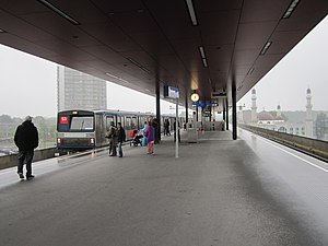
Kraaiennest metro station
Metro station in Amsterdam
Distance: Approx. 847 meters
Latitude and longitude: 52.31638889,4.97944444
Kraaiennest is an Amsterdam Metro station in Amsterdam, Netherlands. The station was renovated and reopened in September 2013, to a design by Dutch-British Architecture Firm Maccreanor Lavington. The renovations resulted in a Royal Institute of British Architects award in 2014.

Gaasperplas metro station
Metro station in Amsterdam
Distance: Approx. 226 meters
Latitude and longitude: 52.31111111,4.98444444
Gaasperplas is an Amsterdam Metro station in Amsterdam, Netherlands.
Zuidoost United
Dutch football club
Distance: Approx. 1607 meters
Latitude and longitude: 52.31181667,4.96416111
Zuidoost United is a Dutch amateur football (soccer) club from the Amsterdam borough of Zuidoost, founded in 2010. The club hold both a Saturday and a Sunday team, competing in sections of the Vierde Klasse league.
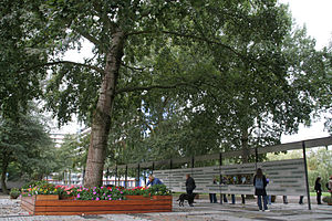
De Boom Die Alles Zag
Tree in Amsterdam
Distance: Approx. 1308 meters
Latitude and longitude: 52.319,4.9741
De Boom Die Alles Zag (transl. The Tree That Saw It All) is a grey poplar (Populus × canescens) tree located in Bijlmermeer, Amsterdam, the Netherlands, that survived the crash of El Al Flight 1862 on 4 October 1992. Due to the eye-shaped patterns on its trunk, the tree was considered to be an eyewitness of the accident and its aftermath.

Jamia Taibah Mosque Amsterdam
Mosque in Amsterdam, the Netherlands
Distance: Approx. 774 meters
Latitude and longitude: 52.3157,4.9798
The Taibah Mosque is a ( Surinamese-Hindustani ) mosque in Amsterdam, the Netherlands. It is affiliated with World Islamic Mission and subscribe to Sunni Barelvi ideology of Islam. It has Jamia Madinatul Islam as center of Islamic learning.
Weather in this IP's area
few clouds
20 Celsius
20 Celsius
19 Celsius
22 Celsius
1009 hPa
70 %
1009 hPa
1009 hPa
10000 meters
6.17 m/s
190 degree
20 %
07:03:29
20:12:09