185.146.63.10 - IP Lookup: Free IP Address Lookup, Postal Code Lookup, IP Location Lookup, IP ASN, Public IP
Country:
Region:
City:
Location:
Time Zone:
Postal Code:
IP information under different IP Channel
ip-api
Country
Region
City
ASN
Time Zone
ISP
Blacklist
Proxy
Latitude
Longitude
Postal
Route
Luminati
Country
ASN
Time Zone
Europe/Berlin
ISP
HKN GmbH
Latitude
Longitude
Postal
IPinfo
Country
Region
City
ASN
Time Zone
ISP
Blacklist
Proxy
Latitude
Longitude
Postal
Route
IP2Location
185.146.63.10Country
Region
nordrhein-westfalen
City
pulheim
Time Zone
Europe/Berlin
ISP
Language
User-Agent
Latitude
Longitude
Postal
db-ip
Country
Region
City
ASN
Time Zone
ISP
Blacklist
Proxy
Latitude
Longitude
Postal
Route
ipdata
Country
Region
City
ASN
Time Zone
ISP
Blacklist
Proxy
Latitude
Longitude
Postal
Route
Popular places and events near this IP address

Electorate of Cologne
Ecclesiastical principality in the Holy Roman Empire
Distance: Approx. 1894 meters
Latitude and longitude: 51,6.83333333
The Electorate of Cologne (German: Kurfürstentum Köln), sometimes referred to as Electoral Cologne (German: Kurköln), was an ecclesiastical principality of the Holy Roman Empire that existed from the 10th to the early 19th century. It consisted of the Hochstift—the temporal possessions—of the archbishop of Cologne, and was ruled by him in his capacity as prince-elector. There were only two other ecclesiastical prince-electors in the Empire: the Electorate of Mainz and the Electorate of Trier.

Pulheim
Town in North Rhine-Westphalia, Germany
Distance: Approx. 444 meters
Latitude and longitude: 51,6.8
Pulheim (; Ripuarian: Pullem) is a town in the Rhein-Erft-Kreis, North Rhine-Westphalia, Germany. Since the 1920s, a large substation of the Rheinisch-Westfälisches Elektrizitätswerk AG (RWE) is located at Pulheim. It is the end of the North–South Powerline and a large control center for the power grid of the RWE. In the communal reform of 1975, several previously independent municipalities were added to the municipality Pulheim, which received city rights in 1981.

Stommeln
Stadtteil of Pulheim in North Rhine-Westphalia, Germany
Distance: Approx. 3957 meters
Latitude and longitude: 51.01972222,6.75972222
Stommeln is a village (Stadtteil), part of the town of Pulheim, in North Rhine-Westphalia, Germany. It has a population of 8,462 (2021).

Brauweiler
Distance: Approx. 4004 meters
Latitude and longitude: 50.96666667,6.78333333
Brauweiler is a part of Pulheim, west of Cologne, North Rhine-Westphalia in Germany. The former Benedictine abbey, Brauweiler Abbey, founded 1024, is used today by the Rhein Department for the Care of Historic Monuments. In Brauweiler in the 1920s a large power transmission station was built, which supplied up to 380 kV. It was also the starting point of the north south powerline.

Brauweiler Abbey
Distance: Approx. 4591 meters
Latitude and longitude: 50.96111111,6.78277778
Brauweiler Abbey (German: Abtei Brauweiler) is a former Benedictine monastery located at Brauweiler, now in Pulheim near Cologne, North Rhine-Westphalia, in Germany. It is now used as a regional cultural center.

Pulheimer Bach
River in Germany
Distance: Approx. 1460 meters
Latitude and longitude: 50.9959,6.8263
Pulheimer Bach is a stream in North Rhine-Westphalia, Germany. Is is 8.5 km (5.3 mi) long. After its final section near town of Pulheim, named the Große Laache, it seeps as groundwater over the course of several years to water treatment works, in a system that has been specially redesigned to better deal with the floodplain environment.

Geyen
Ortsteil of Pulheim in North Rhine-Westphalia, Germany
Distance: Approx. 2419 meters
Latitude and longitude: 50.9818,6.7865
Geyen is a village, part of the town Pulheim in the Rhein-Erft-Kreis, North Rhine-Westphalia, Germany.

Stommeln station
Railway station in Pulheim, Germany
Distance: Approx. 4309 meters
Latitude and longitude: 51.018056,6.752222
Stommeln is a station on the Cologne–Mönchengladbach railway in Rhein-Erft-Kreis in the German state of North Rhine-Westphalia. It is served by the Rhein-Erft-Bahn (RB27) and the Rhein-Erft-Express (RE8).

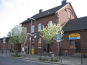
Pulheim station
Railway station in Pulheim, Germany
Distance: Approx. 659 meters
Latitude and longitude: 50.998056,6.797222
Pulheim is a station in the city of Pulheim in the German state of North Rhine-Westphalia. It is on the Cologne–Mönchengladbach railway. It lies between Köln-Bocklemünd station, which was closed the 1970s, and Stommeln station, 11.5 km from Köln-Ehrenfeld station.
Bocklemünd/Mengenich
Stadtteil of Cologne in North Rhine-Westphalia, Germany
Distance: Approx. 4555 meters
Latitude and longitude: 50.97555556,6.85888889
Bocklemünd/Mengenich is a district on the north-western outskirts of Cologne in the urban district of Ehrenfeld. It consists of the villages Bocklemünd and Mengenich, which grew together and administratively merged in 1950.

Görlinger-Zentrum station
Railway station in Cologne, Germany
Distance: Approx. 4971 meters
Latitude and longitude: 50.98055,6.87047
Görlinger-Zentrum is the northwesternmost terminal station of Cologne Stadtbahn line 3, located in Cologne, Germany. The station lies in the Görlinger-Zentrum of the district of Bocklemünd. The station was opened on 27 August 2018 and consists of two side platforms with together two rail tracks.
A. Nattermann
German pharmaceutical company
Distance: Approx. 4464 meters
Latitude and longitude: 50.9766753,6.8585631
A. Nattermann & Cie. GmbH is a German pharmaceutical company headquartered in Cologne-Bocklemünd (North Rhine-Westphalia), Nattermannallee 1.
Weather in this IP's area
broken clouds
1 Celsius
-2 Celsius
0 Celsius
2 Celsius
1029 hPa
93 %
1029 hPa
1022 hPa
10000 meters
2.98 m/s
8.71 m/s
261 degree
84 %
