185.146.59.175 - IP Lookup: Free IP Address Lookup, Postal Code Lookup, IP Location Lookup, IP ASN, Public IP
Country:
Region:
City:
Location:
Time Zone:
Postal Code:
IP information under different IP Channel
ip-api
Country
Region
City
ASN
Time Zone
ISP
Blacklist
Proxy
Latitude
Longitude
Postal
Route
Luminati
Country
Region
cl
City
arroyodelaencomienda
ASN
Time Zone
Europe/Madrid
ISP
Xtra Telecom S.A.
Latitude
Longitude
Postal
IPinfo
Country
Region
City
ASN
Time Zone
ISP
Blacklist
Proxy
Latitude
Longitude
Postal
Route
IP2Location
185.146.59.175Country
Region
galicia
City
vigo
Time Zone
Europe/Madrid
ISP
Language
User-Agent
Latitude
Longitude
Postal
db-ip
Country
Region
City
ASN
Time Zone
ISP
Blacklist
Proxy
Latitude
Longitude
Postal
Route
ipdata
Country
Region
City
ASN
Time Zone
ISP
Blacklist
Proxy
Latitude
Longitude
Postal
Route
Popular places and events near this IP address

Vigo
City in Galicia, Spain
Distance: Approx. 909 meters
Latitude and longitude: 42.231356,-8.712447
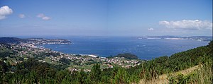
Vigo (Galician: [ˈbiɣʊ], locally [ˈbiħʊ]; Spanish: [ˈbiɣo] ) is a city and municipality in the province of Pontevedra, within the autonomous community of Galicia, Spain. Located in the northwest of the Iberian Peninsula, it sits on the southern shore of an inlet of the Atlantic Ocean, the Ria de Vigo, the southernmost of the Rías Baixas. It is the capital of the comarca of Vigo.

Battle of Vigo Bay
1702 naval battle during the War of the Spanish Succession
Distance: Approx. 515 meters
Latitude and longitude: 42.23725556,-8.72162778
The Battle of Vigo Bay, also known as the Battle of Rande (Galician: Batalla de Rande; Spanish: Batalla de Rande), was a naval engagement fought on 23 October 1702 during the opening years of the War of the Spanish Succession. The engagement followed an Anglo-Dutch attempt to capture the Spanish port of Cádiz in September in an effort to secure a naval base in the Iberian Peninsula. From this station the Allies had hoped to conduct operations in the western Mediterranean Sea, particularly against the French at Toulon.

Rías Baixas
Series of estuarine inlets in Galicia, Spain
Distance: Approx. 909 meters
Latitude and longitude: 42.231356,-8.712447
The Rías Baixas (Galician for "Lower Rias") are a series of four estuarine inlets located on the southwestern coast of Galicia, Spain. They are the Ría de Muros e Noia, the Ría de Arousa, the Ría de Pontevedra, and the Ría de Vigo. The northernmost Rías Baixas begin below Cape Finisterre while the southernmost rias border the Portuguese coast, taking up the southern part of the Province of Coruña and the entire Province of Pontevedra.

Port of Vigo
Port in Spain
Distance: Approx. 926 meters
Latitude and longitude: 42.237,-8.733
Port of Vigo (Galician: Porto de Vigo, Spanish: Puerto de Vigo) is located in Vigo, Pontevedra, Galicia, Spain. Vigo is the base for the big fishing companies which have prominent presence in countries such as Namibia, South Africa, Mozambique, Australia, Argentina, the Falkland Islands, Chile and Peru, among others. Fish is sent all over Spain and abroad to countries like Portugal, Italy, France and other more distant markets including Asia.
Ria de Vigo
Distance: Approx. 2917 meters
Latitude and longitude: 42.25,-8.75
Vigo Ria (Spanish: Ría de Vigo) and (Galician: Ría de Vigo) is an estuary in Galicia, Spain. It is the southernmost ria of the Rías Baixas. It is located in the south of the province of Pontevedra, and extends in a northeast direction over a distance of 35 kilometres (22 mi) from its mouth at Cape Silleiro to the deepest point in Arcade, with a maximum width of 7 km (4.3 mi) and the narrowest in the Strait of Rande, at 700 m (2,300 ft).
RC Celta de Vigo
Association football club in Spain
Distance: Approx. 2697 meters
Latitude and longitude: 42.21183333,-8.73969444
Real Club Celta de Vigo (Galician pronunciation: [reˈal ˈkluβ ˈθeltɐ ðɪ ˈβiɣʊ]; lit. 'Royal Celtic Club of Vigo'), commonly known as Celta Vigo, is a Spanish professional football club based in Vigo, Galicia, that competes in La Liga, the top tier of Spanish football. Nicknamed Os Celestes (The Sky Blues), the club was founded in August 1923 as Club Celta, following the merger of Real Vigo Sporting and Real Fortuna. The club's home stadium is Balaídos, which seats 24,870 spectators.

Garcia Barbon Theatre
Theatre and library in Galicia, Spain
Distance: Approx. 568 meters
Latitude and longitude: 42.23790278,-8.72338889
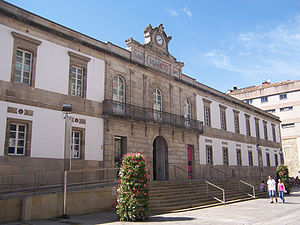
Garcia Barbon Theatre, also known as Afundacion Vigo Theatre (Galician: Teatro Afundación Vigo) for sponsorship reasons, is a 994-seat performing arts center in Vigo, Spain. Designed by Spanish architect Antonio Palacios, it was built in 1927 on the site formerly occupied by the Rosalia de Castro Theatre, destroyed by fire in 1910.

Museum of Contemporary Art, Vigo
Museum in Galicia, Spain
Distance: Approx. 383 meters
Latitude and longitude: 42.23583333,-8.72111111
The Vigo Museum of Contemporary Art (Galician: Museo de Arte Contemporánea de Vigo, abbreviated MARCO) is an art museum in Vigo, (province of Pontevedra), Spain. It displays changing exhibitions of contemporary art, but has no permanent collection.

Vigo-Urzáiz railway station
Distance: Approx. 815 meters
Latitude and longitude: 42.234257,-8.713612
Vigo railway station, also known as Vigo-Urzáiz, is a railway terminus in Vigo, Spain. It provides high speed train connection through the Atlantic Axis high-speed rail line with main Galician cities as Pontevedra, Santiago de Compostela and A Coruña every hour. The station is directly connected through the bus stop in Urzaiz street (50 m from the station hall) with the Airport (line 9A) and the Bus Station (line 4C).

Castro fortress
Distance: Approx. 348 meters
Latitude and longitude: 42.23219444,-8.72743889
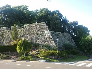
The Fortress of El Castro is a fortification located in Vigo, Spain built in 1665 by the Spanish Empire in the province of Pontevedra during the Portuguese Restoration War to defend the region from potential attacks by English forces. Built on a hill of the same name, the defensive system of Vigo consisted of the fortresses of O Castro and San Sebastián along with the city wall. The city wall had an irregular shape due to the orography of the city, and was constructed by two Spanish Army officers: Colonel Fernando de Gourannanbergue and Maestre de campo Diego Arias Taboada to link the two fortresses together.
Estadio Baltasar Pujales
Football stadium in Spain
Distance: Approx. 2753 meters
Latitude and longitude: 42.22678889,-8.75569167
Estadio Baltasar Pujales is a football stadium in Bouzas, Vigo, Spain, that hosts the home matches of Rapido de Bouzas. It can hold up to 2500 people. The stadium was renovated in 2009.

University Hospital Complex Of Vigo
Hospital in Galicia, Spain
Distance: Approx. 975 meters
Latitude and longitude: 42.241352,-8.720751
The University Hospital Complex of Vigo, known by the acronym CHUVI, is a public health institution established in 2004 that provides health services to the specialized region of the city of Vigo. It depends on the Galician Healthcare Service, and consists of five hospitals and two specialty centers.
Weather in this IP's area
few clouds
9 Celsius
9 Celsius
8 Celsius
9 Celsius
1034 hPa
74 %
1034 hPa
1019 hPa
10000 meters
1.54 m/s
330 degree
20 %

