185.146.162.88 - IP Lookup: Free IP Address Lookup, Postal Code Lookup, IP Location Lookup, IP ASN, Public IP
Country:
 Italy
ItalyRegion:
City:
Location:
Time Zone:
Postal Code:
ISP:
ASN:
language:
User-Agent:
Proxy IP:
Blacklist:
IP information under different IP Channel
ip-api
Country
Region
City
ASN
Time Zone
ISP
Blacklist
Proxy
Latitude
Longitude
Postal
Route
db-ip
Country
Region
City
ASN
Time Zone
ISP
Blacklist
Proxy
Latitude
Longitude
Postal
Route
IPinfo
Country
Region
City
ASN
Time Zone
ISP
Blacklist
Proxy
Latitude
Longitude
Postal
Route
IP2Location
185.146.162.88Country
itRegion
emilia-romagna
City
cesenatico
Time Zone
Europe/Rome
ISP
Language
User-Agent
Latitude
Longitude
Postal
ipdata
Country
Region
City
ASN
Time Zone
ISP
Blacklist
Proxy
Latitude
Longitude
Postal
Route
Popular places and events near this IP address
Rubicon
River in northeastern Italy
Distance: Approx. 4987 meters
Latitude and longitude: 44.1681,12.4431
The Rubicon (Latin: Rubico; Italian: Rubicone [rubiˈkoːne]; Romagnol: Rubicôn [rubiˈkoːŋ]) is a shallow river in northeastern Italy, just south of Cesena and north of Rimini. It was known as Fiumicino until 1933, when it was identified with the ancient river Rubicon, famously crossed by Julius Caesar in 49 BC. The river flows for around 80 km (50 mi) from the Apennine Mountains to the Adriatic Sea through the south of the Emilia-Romagna region, between the towns of Rimini and Cesena.

Cervia
Comune in Emilia-Romagna, Italy
Distance: Approx. 7391 meters
Latitude and longitude: 44.25861111,12.35583333
Cervia (Romagnol: Zirvia) is a seaside resort town in the province of Ravenna, located in the northern Italian region of Emilia-Romagna. Cervia is a major seaside resort in Emilia-Romagna, North Italy. Its population was 28,983 at the 2023 census.
Bellaria – Igea Marina
Comune in Emilia-Romagna, Italy
Distance: Approx. 6883 meters
Latitude and longitude: 44.15,12.45
Bellaria – Igea Marina (Romagnol: Belària – Igea Maròina) is a town and comune in the province of Rimini, northern Italy, with approximately 18,300 inhabitants.
Battle of Cesenatico
1815 battle during the Neapolitan War
Distance: Approx. 220 meters
Latitude and longitude: 44.19901111,12.40156111
The Battle of Cesenatico was a minor battle in the Neapolitan War that took place on 23 April 1815 in the town of Cesenatico on Adriatic coast. The main Neapolitan army, commanded by their king, Joachim Murat, was retreating to their original headquarters in Ancona following a string a defeats in northern Italy. The Neapolitans were being pursued by an Austrian corps under the command of Adam Albert von Neipperg.

Pinarella
Frazione in Emilia-Romagna, Italy
Distance: Approx. 6147 meters
Latitude and longitude: 44.25,12.3667
Pinarella is a frazione of the city of Cervia, Italy.

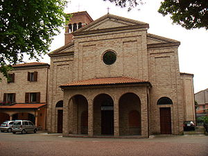
Cervia Cathedral
Distance: Approx. 7871 meters
Latitude and longitude: 44.2609,12.3492
Cervia Cathedral (Italian: Duomo di Cervia; Cattedrale di Santa Maria Assunta) is a Roman Catholic cathedral in the town of Cervia, in the province of Ravenna, region of Emilia-Romagna, Italy. It is the former episcopal seat of the Diocese of Cervia and since 1986 has been a co-cathedral of the Archdiocese of Ravenna-Cervia.

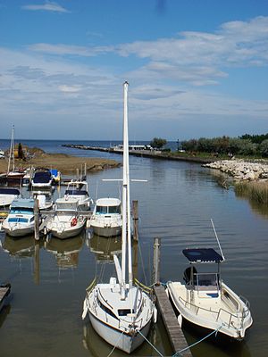
Cesenatico Lighthouse
Lighthouse
Distance: Approx. 718 meters
Latitude and longitude: 44.206108,12.401554
Cesenatico Lighthouse (Italian: Faro di Cesenatico) is an active lighthouse located on the south-west of the entrance to the channel-harbour of Cesenatico, Emilia-Romagna on the Adriatic Sea.

Cesenatico Skyscraper
Skyscraper in Cesenatico, Italy
Distance: Approx. 586 meters
Latitude and longitude: 44.20088,12.40632
The Cesenatico Skyscraper (Italian: Grattacielo di Cesenatico) is a high-rise residential building in Cesenatico, Italy. Originally built between 1957 and 1958, and recladded in 2009, the tower stands at 118 m (387 ft) tall with 35 floors and was the tallest building in Italy between 1958 and 1960.
Weather in this IP's area
overcast clouds
10 Celsius
10 Celsius
9 Celsius
11 Celsius
1021 hPa
92 %
1021 hPa
1018 hPa
10000 meters
0.89 m/s
1.79 m/s
211 degree
100 %