185.144.96.80 - IP Lookup: Free IP Address Lookup, Postal Code Lookup, IP Location Lookup, IP ASN, Public IP
Country:
 Slovakia
Region:
City:
Location:
Time Zone:
Postal Code:
ISP:
ASN:
language:
User-Agent:
Proxy IP:
Blacklist:
IP information under different IP Channel
ip-api
Country
Region
City
ASN
Time Zone
ISP
Blacklist
Proxy
Latitude
Longitude
Postal
Route
db-ip
Country
Region
City
ASN
Time Zone
ISP
Blacklist
Proxy
Latitude
Longitude
Postal
Route
IPinfo
Country
Region
City
ASN
Time Zone
ISP
Blacklist
Proxy
Latitude
Longitude
Postal
Route
IP2Location
185.144.96.80Country
skRegion
trnavsky kraj
City
skalica
Time Zone
Europe/Bratislava
ISP
Language
User-Agent
Latitude
Longitude
Postal
ipdata
Country
Region
City
ASN
Time Zone
ISP
Blacklist
Proxy
Latitude
Longitude
Postal
Route
Popular places and events near this IP address
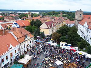
Skalica
Town in Slovakia
Distance: Approx. 299 meters
Latitude and longitude: 48.84222222,17.22666667
Skalica (German: Skalitz, Hungarian: Szakolca, Latin: Sakolcium) is the largest town in Skalica District in western Slovakia in the Záhorie region. Located near the Czech border, Skalica has a population of around 15,000.

Rohatec
Municipality in South Moravian, Czech Republic
Distance: Approx. 5045 meters
Latitude and longitude: 48.88027778,17.18333333
Rohatec is a municipality and village in Hodonín District in the South Moravian Region of the Czech Republic. It has about 3,500 inhabitants.

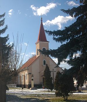
Holíč
Town in Slovakia
Distance: Approx. 6043 meters
Latitude and longitude: 48.81222222,17.16055556
Holíč (until 1946 "Holič", German: Weißkirchen (an der March) / Holitsch, Hungarian: Holics) is a town in western Slovakia.

Trnovec, Slovakia
Municipality in Slovakia
Distance: Approx. 5911 meters
Latitude and longitude: 48.8,17.18333333
Trnovec (Hungarian: Tövisfalva) is a village and municipality in Skalica District in the Trnava Region of western Slovakia.

Kátov
Municipality in Slovakia
Distance: Approx. 4562 meters
Latitude and longitude: 48.83333333,17.16666667
Kátov (Hungarian: Kátó) is a village and municipality in Skalica District in the Trnava Region of western Slovakia.

Mokrý Háj
Municipality in Slovakia
Distance: Approx. 3587 meters
Latitude and longitude: 48.81666667,17.25
Mokrý Háj (Hungarian: Horvátberek) is a village and municipality in Skalica District in the Trnava Region of western Slovakia.

Prietržka
Municipality in Slovakia
Distance: Approx. 4965 meters
Latitude and longitude: 48.805,17.19611111
Prietržka (Hungarian: Kispetrős) is a village and municipality in Skalica District in the Trnava Region of western Slovakia.
Vrádište
Municipality in Slovakia
Distance: Approx. 3691 meters
Latitude and longitude: 48.81666667,17.2
Vrádište (Hungarian: Várköz) is a village and municipality in Skalica District in the Trnava Region of western Slovakia.

Petrov (Hodonín District)
Municipality in South Moravian, Czech Republic
Distance: Approx. 5596 meters
Latitude and longitude: 48.88194444,17.27805556
Petrov is a municipality and village in Hodonín District in the South Moravian Region of the Czech Republic. It has about 1,300 inhabitants.

Sudoměřice
Municipality in South Moravian, Czech Republic
Distance: Approx. 3330 meters
Latitude and longitude: 48.86722222,17.25666667
Sudoměřice is a municipality and village in Hodonín District in the South Moravian Region of the Czech Republic. It has about 1,300 inhabitants.

Mestský štadión Skalica
Football stadium in Skalica, Slovakia
Distance: Approx. 597 meters
Latitude and longitude: 48.83953611,17.22668611
The Municipal Stadium (Slovak: Mestský štadión) in Skalica, Slovakia, also colloquially known as Letňák, is a football stadium that serves as the home ground of MFK Skalica and has capacity of 2,600. The stadium is also equipped with a 6-lane 400-meter athletic track.

Holíč Castle
Historical landmark in Holíč, Slovakia
Distance: Approx. 6482 meters
Latitude and longitude: 48.808618,17.157223
Holíč Castle is a Baroque manor house and a historical landmark in Holíč, Slovakia. The manor house was built as a summer residence by the Habsburgs in the 18th century. It replaced an older military fortification dating back to the 12th century.
Weather in this IP's area
overcast clouds
0 Celsius
-4 Celsius
0 Celsius
0 Celsius
1023 hPa
82 %
1023 hPa
996 hPa
10000 meters
3.13 m/s
6.26 m/s
108 degree
100 %