185.143.142.130 - IP Lookup: Free IP Address Lookup, Postal Code Lookup, IP Location Lookup, IP ASN, Public IP
Country:
Region:
City:
Location:
Time Zone:
Postal Code:
IP information under different IP Channel
ip-api
Country
Region
City
ASN
Time Zone
ISP
Blacklist
Proxy
Latitude
Longitude
Postal
Route
Luminati
Country
ASN
Time Zone
Europe/Madrid
ISP
Aire Networks Del Mediterraneo Sl Unipersonal
Latitude
Longitude
Postal
IPinfo
Country
Region
City
ASN
Time Zone
ISP
Blacklist
Proxy
Latitude
Longitude
Postal
Route
IP2Location
185.143.142.130Country
Region
asturias, principado de
City
villaviciosa
Time Zone
Europe/Madrid
ISP
Language
User-Agent
Latitude
Longitude
Postal
db-ip
Country
Region
City
ASN
Time Zone
ISP
Blacklist
Proxy
Latitude
Longitude
Postal
Route
ipdata
Country
Region
City
ASN
Time Zone
ISP
Blacklist
Proxy
Latitude
Longitude
Postal
Route
Popular places and events near this IP address

Villaviciosa, Asturias
Municipality in Asturias, Spain
Distance: Approx. 296 meters
Latitude and longitude: 43.48333333,-5.43333333
Villaviciosa (Asturian pronunciation: [biʎaβiˈθjosa], Spanish pronunciation: [biʝaβiˈθjosa]) is a town and municipality in the autonomous community of Asturias, Spain.
CD Lealtad
Association football club in Spain
Distance: Approx. 630 meters
Latitude and longitude: 43.486368,-5.432234
Club Deportivo Lealtad de Villaviciosa (English: Loyalty Sporting Club of Villaviciosa) is a Spanish football team based in Villaviciosa, in the autonomous community of Asturias. Founded in 1916, it plays in Tercera Federación – Group 2, holding home games at Les Caleyes ground with a capacity of 3,000.

Amandi (Villaviciosa)
Distance: Approx. 1640 meters
Latitude and longitude: 43.466667,-5.433333
Amandi is one of 41 parishes (administrative divisions) in Villaviciosa, a municipality within the province and autonomous community of Asturias, in northern Spain. Situated at 171 m (561 ft) above sea level, the parroquia is 5.06 km2 (1.95 sq mi) in size, with a population of 519 (INE 2011). The postal code is 33311.
Arnín
Distance: Approx. 1640 meters
Latitude and longitude: 43.466667,-5.433333
Arnín is one of 41 parishes (administrative divisions) in Villaviciosa, a municipality within the province and autonomous community of Asturias, in northern Spain.

Bedriñana
Distance: Approx. 2090 meters
Latitude and longitude: 43.5,-5.433333
Bedriñana is one of 41 parishes (administrative divisions) in Villaviciosa, a municipality within the province and autonomous community of Asturias, in northern Spain. The parroquia is 8.77 km2 (3.39 sq mi) in size, with a population of 253 (INE 2005).
Camoca
Distance: Approx. 2985 meters
Latitude and longitude: 43.466667,-5.466667
Camoca is one of 41 parishes (administrative divisions) in Villaviciosa, a municipality within the province and autonomous community of Asturias, in northern Spain. The parroquia is 3.51 km2 (1.36 sq mi) in size, with a population of 132 (INE 2005).
Carda
Parish in Villaviciosa, Asturias, Spain
Distance: Approx. 1554 meters
Latitude and longitude: 43.483333,-5.416667
Carda is one of 41 parishes (administrative divisions) in Villaviciosa, a municipality within the province and autonomous community of Asturias, in northern Spain. The parroquia is 3.51 km2 (1.36 sq mi) in size, with a population of 75 (INE 2005).

Grases
Distance: Approx. 2985 meters
Latitude and longitude: 43.466667,-5.466667
Grases (is one of 41 parishes (administrative divisions) in Villaviciosa, a municipality within the province and autonomous community of Asturias, in northern Spain. Situated at 68 m (223 ft) above sea level, the parroquia is 2.78 km2 (1.07 sq mi) in size, with a population of 112 (INE 2007).

Iglesia de San Andrés (Bedriñana)
Church in Asturias, Spain
Distance: Approx. 2141 meters
Latitude and longitude: 43.50044,-5.43832
Iglesia de San Andrés (Bedriñana) is a church in the parish of Bedriñana, Asturias, Spain. It dates to the 9th century and was declared a national monument in 1931.

Iglesia de San Juan (Amandi)
Church in Asturias, Spain
Distance: Approx. 1437 meters
Latitude and longitude: 43.4692,-5.4419
Iglesia de San Juan (Amandi) is a church in Asturias, Spain. It was established in the 13th century.

Iglesia de Santa María (Lugás)
Church in Asturias, Spain
Distance: Approx. 3226 meters
Latitude and longitude: 43.45277778,-5.42861111
Iglesia de Santa María (Lugás) is a church in Asturias, Spain.

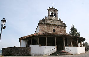
Iglesia de Santa María de la Oliva (Villaviciosa)
Church in Principality of Asturias, Spain
Distance: Approx. 115 meters
Latitude and longitude: 43.48193,-5.43683
Iglesia de Santa María de la Oliva is a late 13th to early 14th century stone church in Villaviciosa of the autonomous community of the Principality of Asturias, in Spain. The church and town is on the coast of Biscay Bay in northern Spain. It was built in the late 13th and early 14th centuries.
Weather in this IP's area
broken clouds
11 Celsius
11 Celsius
11 Celsius
12 Celsius
1035 hPa
94 %
1035 hPa
1008 hPa
10000 meters
1.42 m/s
2.44 m/s
99 degree
56 %