Country:
Region:
City:
Latitude and Longitude:
Time Zone:
Postal Code:
IP information under different IP Channel
ip-api
Country
Region
City
ASN
Time Zone
ISP
Blacklist
Proxy
Latitude
Longitude
Postal
Route
Luminati
Country
ASN
Time Zone
Europe/Rome
ISP
Wildcard Service Srl
Latitude
Longitude
Postal
IPinfo
Country
Region
City
ASN
Time Zone
ISP
Blacklist
Proxy
Latitude
Longitude
Postal
Route
db-ip
Country
Region
City
ASN
Time Zone
ISP
Blacklist
Proxy
Latitude
Longitude
Postal
Route
ipdata
Country
Region
City
ASN
Time Zone
ISP
Blacklist
Proxy
Latitude
Longitude
Postal
Route
Popular places and events near this IP address

Sampierdarena
Italian city
Distance: Approx. 1656 meters
Latitude and longitude: 44.41666667,8.9
Sampierdarena (also San Pier d'Arena; Ligurian: San Pè d'ænn-a) is a major port and industrial area of Genoa, in northwest Italy. With San Teodoro it forms the West Central (Centro Ovest) municipio.
Vaillant Palace
Distance: Approx. 564 meters
Latitude and longitude: 44.412145,8.879716
RDS Stadium (formerly Mazda Palace and Vaillant Palace) is an indoor sporting arena located in Genoa, Italy. The capacity of the arena is 5,500 people. It hosts concerts and indoor sporting events.

Genova Sampierdarena railway station
Railway station in Genoa, Italy
Distance: Approx. 806 meters
Latitude and longitude: 44.41305556,8.8875
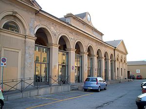
Genova Sampierdarena railway station (Italian: Stazione di Genova Sampierdarena) is located in Piazza Montano, in the Sampierdarena district of Genoa, Italy. It is Genoa's third most important railway station, after Genova Piazza Principe and Genova Brignole. The station is owned by Rete Ferroviaria Italiana (RFI), a subsidiary of the Ferrovie dello Stato (FS) group.
Brin (Genoa Metro)
Genoa Metro station
Distance: Approx. 1776 meters
Latitude and longitude: 44.42805556,8.89555556
Brin is a Genoa Metro station. It is situated along Via Benedetto Brin in the neighbourhood of Certosa in Rivarolo Ligure, a suburban area in the north-western outskirts of Genoa, Italy. The station, currently the terminus of the line, is located just west of the outlet of the tunnel from Dinegro station.

Genoa Erzelli GREAT Campus
Place in Italy, European Union
Distance: Approx. 1612 meters
Latitude and longitude: 44.42579722,8.86288056
The GREAT Campus is a science technology park located on the Erzelli hill in Genoa, in northwest Italy. The park is partly under ongoing construction and partly already working. At the moment, it hosts several high tech corporations such as Ericsson, Siemens, and Esaote, in addition to a robotics laboratory of the Istituto Italiano di Tecnologia (IIT) and other companies.

Polcevera
Italian river
Distance: Approx. 1130 meters
Latitude and longitude: 44.4075,8.875
The Polcevera (in Ligurian Pûçéivia or Ponçéivia) is a 19-kilometre (12 mi) river in Liguria (Italy).

Matitone
Distance: Approx. 2276 meters
Latitude and longitude: 44.4113,8.9066
The Matitone (a popular nickname meaning literally "big pencil", officially San Benigno North Tower) is a skyscraper designed by Skidmore, Owings & Merrill, Mario Lanata and Andrea Messina and finished building in 1992, used as a business center located in the district of San Teodoro, in the San Benigno neighborhood, near the Genova-West highway.

Ponte Morandi
Road bridge in Genoa, Italy
Distance: Approx. 1232 meters
Latitude and longitude: 44.42583333,8.88888889
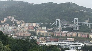
Ponte Morandi (English: Morandi Bridge), officially Viadotto Polcevera (English: Polcevera Viaduct), was a road viaduct in Genoa, Liguria, Italy, constructed between 1963 and 1967 along the A10 motorway over the Polcevera River, from which it derived its official name. It connected Genoa's Sampierdarena and Cornigliano districts across the Polcevera Valley. The bridge was widely called "Ponte Morandi" after its structural designer, engineer Riccardo Morandi.
Borzoli
Quartiere in Liguria, Italy
Distance: Approx. 2072 meters
Latitude and longitude: 44.43421,8.8686
Borzoli is a quartiere of the Italian city of Genoa, located west of the city centre.

Genoa-Saint George Bridge
Motorway viaduct in Genoa, Italy
Distance: Approx. 1232 meters
Latitude and longitude: 44.42583333,8.88888889
The Genoa Saint George Bridge (Italian: Viadotto Genova-San Giorgio) is a motorway viaduct that crosses the Polcevera river and the districts of Sampierdarena and Cornigliano, in the city of Genoa. It was designed by architect Renzo Piano. The bridge replaces the Ponte Morandi (Polcevera Viaduct), which partially collapsed on 14 August 2018 and was demolished in June 2019.

2018 Ponte Morandi collapse
Bridge collapse in Genoa, Italy
Distance: Approx. 1232 meters
Latitude and longitude: 44.42583333,8.88888889
On 14 August 2018, around 11:36 local time (09:36 UTC) a section of the Ponte Morandi (English: Morandi Bridge) in Genoa, Liguria, Italy, collapsed during a rainstorm, killing forty-three people. The remains were demolished in June 2019. The replacement bridge, the Genoa-Saint George Bridge was inaugurated a year later.

MSC Tower
Skyscraper in Genoa, Italy
Distance: Approx. 2118 meters
Latitude and longitude: 44.40733611,8.90196389
The MSC Tower (Italian: Torre MSC) is an office skyscraper located in Genoa, Italy.
Weather in this IP's area
clear sky
8 Celsius
8 Celsius
6 Celsius
9 Celsius
1024 hPa
67 %
1024 hPa
1023 hPa
10000 meters
0.89 m/s
2.68 m/s
39 degree
07:19:40
16:58:28
