185.142.28.192 - IP Lookup: Free IP Address Lookup, Postal Code Lookup, IP Location Lookup, IP ASN, Public IP
Country:
 Ireland
Region:
City:
Location:
Time Zone:
Postal Code:
ISP:
ASN:
language:
User-Agent:
Proxy IP:
Blacklist:
IP information under different IP Channel
ip-api
Country
Region
City
ASN
Time Zone
ISP
Blacklist
Proxy
Latitude
Longitude
Postal
Route
db-ip
Country
Region
City
ASN
Time Zone
ISP
Blacklist
Proxy
Latitude
Longitude
Postal
Route
IPinfo
Country
Region
City
ASN
Time Zone
ISP
Blacklist
Proxy
Latitude
Longitude
Postal
Route
IP2Location
185.142.28.192Country
ieRegion
roscommon
City
boyle
Time Zone
Europe/Dublin
ISP
Language
User-Agent
Latitude
Longitude
Postal
ipdata
Country
Region
City
ASN
Time Zone
ISP
Blacklist
Proxy
Latitude
Longitude
Postal
Route
Popular places and events near this IP address

Boyle, County Roscommon
Town in County Roscommon, Ireland
Distance: Approx. 704 meters
Latitude and longitude: 53.973,-8.301
Boyle (; Irish: Mainistir na Búille) is a town in County Roscommon, Ireland. It is located at the foot of the Curlew Mountains near Lough Key in the north of the county. Carrowkeel Megalithic Cemetery, the Drumanone Dolmen and the lakes of Lough Arrow and Lough Gara are also close by.

Lough Key
Lake in Ireland
Distance: Approx. 4945 meters
Latitude and longitude: 54,-8.25
Lough Key (Irish: Loch Cé) is a lake in Ireland. It is in the northwest of County Roscommon, northeast of the town of Boyle. The lough is believed to be named after a mythical figure named Cé.

Battle of Curlew Pass
1599 battle of the Nine Years' War
Distance: Approx. 3521 meters
Latitude and longitude: 53.9975,-8.31222194
The Battle of Curlew Pass was fought on 15 August 1599 during the campaign of the Earl of Essex in the Nine Years' War, between an English force under Sir Conyers Clifford and a rebel Irish force led by Aodh Ruadh Ó Domhnaill (Red Hugh O'Donnell). The English were ambushed and routed while marching through a pass in the Curlew Mountains, near the town of Boyle, in the west of Ireland. The English forces suffered heavy casualties.
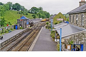
Boyle railway station
Railway station in Ireland
Distance: Approx. 287 meters
Latitude and longitude: 53.9675,-8.30416667
Boyle railway station serves the town of Boyle in County Roscommon, Ireland.

Boyle Abbey
Ruined Cistercian abbey in Roscommon, Ireland
Distance: Approx. 795 meters
Latitude and longitude: 53.97361111,-8.29694444
Boyle Abbey (Irish: Mainistir na Búille) is a ruined Cistercian friary located in Boyle, County Roscommon, Ireland. It was founded by Saint Malachy in the 12th century.
Lough Key Forest Park
Park in County Roscommon, Ireland
Distance: Approx. 3761 meters
Latitude and longitude: 53.98333333,-8.25
Lough Key Forest Park is an 800-hectare park on the southern shore of Lough Key, 40 km south east of Sligo town and 3 km east of Boyle, County Roscommon, Ireland. Formerly part of the Rockingham Estate laid out by the King family, it is open to the public.

Cavetown Lough
Freshwater lake in the west of Ireland
Distance: Approx. 5385 meters
Latitude and longitude: 53.925,-8.25833333
Cavetown Lough (Irish: Loch Bhaile na hUamha) is a freshwater lake in the west of Ireland. It is located in County Roscommon in the catchment of the upper River Shannon.

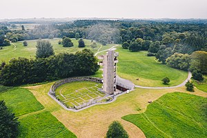
Holy Trinity Abbey, Lough Key
Distance: Approx. 3883 meters
Latitude and longitude: 53.989217,-8.254697
Holy Trinity Abbey is a former medieval Premonstratensian priory and National Monument located in Lough Key, Ireland.

Inchmacnerin Abbey
Irish former monastery
Distance: Approx. 4019 meters
Latitude and longitude: 53.994501,-8.260823
Inchmacnerin Abbey (Irish: Mainistir Inis Mac nÉirín) is a former monastery and National Monument located in Lough Key, Ireland.

McDermott's Castle
Castle in County Roscommon, Ireland
Distance: Approx. 5093 meters
Latitude and longitude: 53.989522,-8.23258
McDermott's Castle is a castle and protected national monument located in County Roscommon, Ireland. The site of a fortification since at least the 13th century, the structure's tower house may date from the 16th century, with much of the current building (including its crenellations) dating to the 19th century.

Rockingham Estate
House in County Roscommon, Ireland
Distance: Approx. 4623 meters
Latitude and longitude: 53.985709,-8.237224
Rockingham Estate was a house and estate near Boyle, County Roscommon, Ireland covering much of the area which now makes up Lough Key Forest Park.
Boyle GAA
Distance: Approx. 914 meters
Latitude and longitude: 53.97475,-8.29725
Boyle GAA (Irish: CLG Mainistir na Búille) is a Gaelic Athletic Association club based in Boyle, County Roscommon. The club was founded in 1889 and plays in maroon and white.
Weather in this IP's area
light rain
9 Celsius
6 Celsius
9 Celsius
9 Celsius
1009 hPa
93 %
1009 hPa
998 hPa
10000 meters
7.45 m/s
16.74 m/s
156 degree
100 %