Country:
 Lithuania
Region:
City:
Latitude and Longitude:
Time Zone:
Postal Code:
IP information under different IP Channel
ip-api
Country
Region
City
ASN
Time Zone
ISP
Blacklist
Proxy
Latitude
Longitude
Postal
Route
IPinfo
Country
Region
City
ASN
Time Zone
ISP
Blacklist
Proxy
Latitude
Longitude
Postal
Route
MaxMind
Country
Region
City
ASN
Time Zone
ISP
Blacklist
Proxy
Latitude
Longitude
Postal
Route
Luminati
Country
LTASN
Time Zone
Europe/Vilnius
ISP
UAB Baltnetos komunikacijos
Latitude
Longitude
Postal
db-ip
Country
Region
City
ASN
Time Zone
ISP
Blacklist
Proxy
Latitude
Longitude
Postal
Route
ipdata
Country
Region
City
ASN
Time Zone
ISP
Blacklist
Proxy
Latitude
Longitude
Postal
Route
Popular places and events near this IP address

Verkiai Palace
Building in Vilnius, Lithuania
Distance: Approx. 1544 meters
Latitude and longitude: 54.748056,25.292778
Verkiai Palace (Lithuanian: Verkių rūmai) is an 18th-century neoclassical mansion in Verkiai, Vilnius, Lithuania.

Verkiai Regional Park
Distance: Approx. 3628 meters
Latitude and longitude: 54.78055556,25.33055556
Verkiai Regional Park is one of the Regional Parks in Lithuania. It is located almost entirely in Verkiai elderate of Vilnius municipality. The park was established in 1992 in order to protect natural complexes of the Green (Žalieji) Lakes and cultural complexes of Verkiai Palace and a park, Kalvarijos and Trinapolis as well as other valuables.

Valakampiai Bridge
Bridge in Lithuania
Distance: Approx. 4249 meters
Latitude and longitude: 54.72638889,25.31222222
Valakampiai Bridge (Lithuanian: Valakampių tiltas) also known as Valakupiai Bridge (Lithuanian: Valakupių tiltas) is a bridge across Neris River, that connects Žirmūnai and Antakalnis districts of Vilnius. Built in 1972. As of 2007, it is the longest bridge in Vilnius, 341.5 metres long and approximately 21.0 metres wide.
Battle of Verkiai
1658 battle
Distance: Approx. 1493 meters
Latitude and longitude: 54.74833333,25.29166667
Battle of Verkiai fought in autumn of 1658 between the Polish–Lithuanian Commonwealth and the Tsardom of Russia marked the resumption of hostilities in the Russo-Polish War (1654–67); it ended with Russian victory. Russians, close to signing a peace treaty with Sweden (truce of Valiersari ending the Russo–Swedish War (1656–58)) decided to resume the war with Poland in order to gain control over the disputed Ruthenian territories. After the inconclusive negotiations with the Poles in Vilnius, army of prince Yury Dolgorukov attacked the Polish units guarding the Polish delegations near Verkiai.
Neris Regional Park
Park in Vilnius County, Lithuania
Distance: Approx. 3988 meters
Latitude and longitude: 54.751575,25.22529722
Neris Regional Park was established in 1992 and covers about 10,000 hectares in Lithuania. Its territory lies within the Vilnius district municipality, the Trakai district municipality, and the Elektrėnai municipality. Portions of the park are privately owned.

Vilnius St. Joseph Seminary
Roman Catholic seminary in Vilnius, Lithuania
Distance: Approx. 2610 meters
Latitude and longitude: 54.73805556,25.27861111
The Vilnius St. Joseph Seminary is a Roman Catholic seminary in Vilnius, Lithuania. It traces its history to an institution founded by Cardinal Jurgis Radvila in 1582.

Vilnius University Hospital Santaros Klinikos
Hospital in Vilnius, Lithuania
Distance: Approx. 1133 meters
Latitude and longitude: 54.75194444,25.27777778
Vilnius University Hospital Santaros Klinikos (Lithuanian: Vilniaus Universiteto ligoninė Santaros klinikos, formerly known as Santariškių Klinikos ) in Vilnius, Lithuania is a teaching hospital of the Vilnius University Faculty of Medicine. Santaros Klinikos is co-funded by the Lithuanian Ministry of Health and Vilnius University. It has a staff of 5372 employees, including 1409 medical doctors, 1978 nurses and other highly qualified professionals.

Verkiai Calvary
Place of worship in Vilnius, Lithuania
Distance: Approx. 3383 meters
Latitude and longitude: 54.73083333,25.28722222
Verkiai Calvary or Vilnius Calvary is the second oldest calvary in Lithuania after Žemaičių Kalvarija. It is located in Verkiai, a neighborhood of Vilnius, capital of Lithuania. The calvary was built in 1662–69 as a sign of gratitude for the victory in the Second Northern War (1655–60).

Church of the Discovery of the Holy Cross, Vilnius
Distance: Approx. 2333 meters
Latitude and longitude: 54.740462,25.279809
The Church of the Discovery of the Holy Cross (Lithuanian: Šv. Kryžiaus Atradimo bažnyčia) is a Roman Catholic church in Jeruzalė neighborhood of Vilnius, Lithuania. Located on the right bank of Neris River, it is the centerpiece of the Vilnius Calvary, a 35-station Way of the Cross.

Verkė
River in Lithuania
Distance: Approx. 1807 meters
Latitude and longitude: 54.74538,25.29143
The Verkė is a small (around 2 km. long) rivulet in Vilnius, Lithuania, which gave the name to the Verkiai neighborhood. According to the legend, the Verkė was the birthplace of the semi-legendary pagan priest Lizdeika, a forefather of the Radziwiłł family, a Polish princely family.

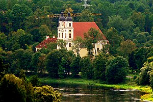
Church of the Holy Trinity in Trinapolis, Vilnius
Roman Catholic church in Vilnius, Lithuania built in 1715–1721
Distance: Approx. 3372 meters
Latitude and longitude: 54.73111111,25.29111111
Church of the Holy Trinity (Lithuanian: Švč. Trejybės bažnyčia) is a Roman Catholic church in Trinapolis, one of the parts of Lithuania's capital Vilnius. The church was built in 1715–1721 and consecrated in 1722.

Jeruzalė
Neighborhood of Vilnius. Lithuania
Distance: Approx. 2077 meters
Latitude and longitude: 54.743,25.278
Jeruzalė ("Jerusalem" in Lithuanian) is a neighborhood of Vilnius under the administration of the Verkiai eldersip (lt:Verkių seniūnija). It is located just north of the Vilnius city center, neighboring with Santariškės, Verkiai, Baltupiai, and Visoriai,approximately bordered by the Mokslininkų ("Scientists") street in the north, Iron Wolf street in the west, Ateities street in the south, and the Jeruzalė street in the east.
Weather in this IP's area
clear sky
22 Celsius
21 Celsius
20 Celsius
22 Celsius
1024 hPa
44 %
1024 hPa
1006 hPa
10000 meters
3.6 m/s
150 degree
06:39:08
19:54:10