185.14.11.244 - IP Lookup: Free IP Address Lookup, Postal Code Lookup, IP Location Lookup, IP ASN, Public IP
Country:
 Italy
ItalyRegion:
City:
Location:
Time Zone:
Postal Code:
ISP:
ASN:
language:
User-Agent:
Proxy IP:
Blacklist:
IP information under different IP Channel
ip-api
Country
Region
City
ASN
Time Zone
ISP
Blacklist
Proxy
Latitude
Longitude
Postal
Route
db-ip
Country
Region
City
ASN
Time Zone
ISP
Blacklist
Proxy
Latitude
Longitude
Postal
Route
IPinfo
Country
Region
City
ASN
Time Zone
ISP
Blacklist
Proxy
Latitude
Longitude
Postal
Route
IP2Location
185.14.11.244Country
itRegion
emilia-romagna
City
formigine
Time Zone
Europe/Rome
ISP
Language
User-Agent
Latitude
Longitude
Postal
ipdata
Country
Region
City
ASN
Time Zone
ISP
Blacklist
Proxy
Latitude
Longitude
Postal
Route
Popular places and events near this IP address
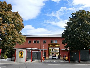
Ferrari
Italian luxury sports car manufacturer
Distance: Approx. 4716 meters
Latitude and longitude: 44.5325,10.86444444
Ferrari S.p.A. (; Italian: [ferˈraːri]) is an Italian luxury sports car manufacturer based in Maranello. Founded in 1939 by Enzo Ferrari (1898–1988), the company built its first car in 1940, adopted its current name in 1945, and began to produce its current line of road cars in 1947. Ferrari became a public company in 1960, and from 1963 to 2014 it was a subsidiary of Fiat S.p.A. It was spun off from Fiat's successor entity, Fiat Chrysler Automobiles, in 2016.
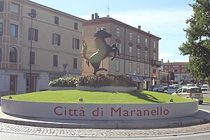
Maranello
Comune in Emilia-Romagna, Italy
Distance: Approx. 5418 meters
Latitude and longitude: 44.52638889,10.86666667
Maranello (Modenese: Maranèl) is a city of Italy in the province of Modena, in the region of Emilia-Romagna, 18 km from Modena, with a population of 17,504 as of 2017. It is known worldwide as the home of Ferrari and the Formula One racing team, Scuderia Ferrari. Maranello was also home to coachbuilding firm Carrozzeria Scaglietti, owned by Ferrari.

Sassuolo
Comune in Emilia-Romagna, Italy
Distance: Approx. 5662 meters
Latitude and longitude: 44.55,10.78333333
Sassuolo (Italian pronunciation: [sasˈswɔːlo]; Modenese: Sasól [saˈsoːl]) is an Italian town, comune, and industrial centre of the Province of Modena in Emilia-Romagna. Standing on the right bank of the river Secchia some 17 kilometres (11 mi) southwest of Modena, the town is best known for being the centre of the Italian tile industry and for being the home town of Serie B side U.S. Sassuolo Calcio.
Formigine
Comune in Emilia-Romagna, Italy
Distance: Approx. 7833 meters
Latitude and longitude: 44.60722222,10.93333333
Formigine (Modenese: Furméżen) is a town and comune in the province of Modena, Emilia-Romagna, Italy. As of 2023, Formigine had an estimated population of 34,406.

Casalgrande
Comune in Emilia-Romagna, Italy
Distance: Approx. 9086 meters
Latitude and longitude: 44.58333333,10.73333333
Casalgrande (Reggiano: Càsalgrând) is a comune (municipality) in the Province of Reggio Emilia in the Italian region Emilia-Romagna, located about 50 kilometres (31 mi) west of Bologna and about 15 kilometres (9 mi) southeast of Reggio Emilia. As of 8 January 2017, it had a population of 19,215 and an area of 37.7 square kilometres (14.6 sq mi). The municipality of Casalgrande contains the frazioni (subdivisions, mainly villages and hamlets) Boglioni, Casalgrande Alto, Dinazzano, Salvaterra, San Donnino di Liguria, Sant'Antonino, Veggia and Villalunga.

Castellarano
Comune in Emilia-Romagna, Italy
Distance: Approx. 5098 meters
Latitude and longitude: 44.56666667,10.78333333
Castellarano (Reggiano: Castlarân) is a comune (municipality) in the Province of Reggio Emilia in the Italian region Emilia-Romagna, located about 45 kilometres (28 mi) west of Bologna and about 20 kilometres (12 mi) southeast of Reggio Emilia. Castellarano borders the following municipalities: Baiso, Casalgrande, Prignano sulla Secchia, Sassuolo, Scandiano, Viano.
Castelnuovo Rangone
Comune in Emilia-Romagna, Italy
Distance: Approx. 7311 meters
Latitude and longitude: 44.55,10.93333333
Castelnuovo Rangone (Modenese: Castelnôv) is a comune (municipality) in the Province of Modena in the Italian region Emilia-Romagna, located about 40 kilometres (25 mi) west of Bologna and about 13 kilometres (8 mi) south of Modena. The most important economic activity is the production and treatment of pork. Castelnuovo Rangone includes the following frazioni: Balugola, Cavidole, Montale Rangone, San Lorenzo, Settecani, Ca' Bergomi, Gualinga, Castello, Oratorio di Sant'Anna, Santa Lucia.

Fiorano Circuit
Private race track in Italy
Distance: Approx. 4441 meters
Latitude and longitude: 44.53388889,10.85805556
The Fiorano Circuit (Italian: Pista di Fiorano) is a private racetrack owned by Ferrari for development and testing purposes. It is located in Fiorano Modenese, near the Italian town of Maranello. The circuit has FIA Grade 2 license.
Stadio Enzo Ricci
Distance: Approx. 5892 meters
Latitude and longitude: 44.54027778,10.78861111
Stadio Enzo Ricci is a multi-use stadium in Sassuolo, Italy. It holds 4,008 people. It was used as professional football club U.S. Sassuolo Calcio's home ground prior to their promotion to Serie B in 2008, when it agreed on a move to the larger Stadio Alberto Braglia in Modena.

Ducal Palace of Sassuolo
Distance: Approx. 6306 meters
Latitude and longitude: 44.5425,10.78
The Ducal Palace in Sassuolo is a Baroque villa located in the town of Sassuolo, thirty minutes outside Modena, northern Italy.

Autodromo di Modena
Distance: Approx. 9785 meters
Latitude and longitude: 44.65027778,10.90583333
Autodromo di Modena (or Aerautodromo di Modena) was a race track on the edge of Modena in Italy. The track had a length of 2.366 km (1.470 mi). It was opened in 1950 and the circuit was crossed by an airstrip of about 1.600 km (0.994 mi) in length which was used by the local flying club.
San Giuseppe, Sassuolo
Distance: Approx. 6066 meters
Latitude and longitude: 44.541665,10.78444194
San Giuseppe is a former-Roman Catholic church and former convent in Sassuolo, Region of Emilia Romagna, Italy.
Weather in this IP's area
overcast clouds
8 Celsius
6 Celsius
7 Celsius
8 Celsius
1025 hPa
100 %
1025 hPa
1008 hPa
10000 meters
3.18 m/s
6.55 m/s
75 degree
100 %