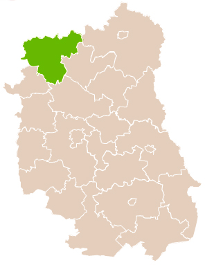
Country:
Region:
City:
Latitude and Longitude:
Time Zone:
Postal Code:
IP information under different IP Channel
ip-api
Country
Region
City
ASN
Time Zone
ISP
Blacklist
Proxy
Latitude
Longitude
Postal
Route
Luminati
Country
Region
06
City
krzywda
ASN
Time Zone
Europe/Warsaw
ISP
Telekom System sp.z o.o.
Latitude
Longitude
Postal
IPinfo
Country
Region
City
ASN
Time Zone
ISP
Blacklist
Proxy
Latitude
Longitude
Postal
Route
db-ip
Country
Region
City
ASN
Time Zone
ISP
Blacklist
Proxy
Latitude
Longitude
Postal
Route
ipdata
Country
Region
City
ASN
Time Zone
ISP
Blacklist
Proxy
Latitude
Longitude
Postal
Route
Popular places and events near this IP address

Łuków
Town in Lublin Voivodeship, Poland
Distance: Approx. 615 meters
Latitude and longitude: 51.92722222,22.38333333
Łuków [ˈwukuf] is a city in eastern Poland with 30,727 inhabitants (as of January 1, 2005). Since 1999, it has been situated in the Lublin Voivodeship, previously it had belonged to the Siedlce Voivodeship (between 1975–1998). It is the capital of Łuków County.

Łuków County
County in Lublin Voivodeship, Poland
Distance: Approx. 1500 meters
Latitude and longitude: 51.91666667,22.38333333
Łuków County (Polish: powiat łukowski) is a unit of territorial administration and local government (powiat) in Lublin Voivodeship, eastern Poland. It was established on January 1, 1999, as a result of the Polish local government reforms passed in 1998. Its administrative seat and largest town is Łuków, which lies 76 kilometres (47 mi) north of the regional capital Lublin.
Gmina Łuków
Gmina in Lublin Voivodeship, Poland
Distance: Approx. 1500 meters
Latitude and longitude: 51.91666667,22.38333333
Gmina Łuków is a rural gmina (administrative district) in Łuków County, Lublin Voivodeship, in eastern Poland. Its seat is the town of Łuków, although the town is not part of the territory of the gmina. The gmina covers an area of 308.32 square kilometres (119.0 sq mi), and as of 2006, its total population was 16,547.
Gołaszyn, Lublin Voivodeship
Village in Lublin Voivodeship, Poland
Distance: Approx. 2887 meters
Latitude and longitude: 51.95,22.35
Gołaszyn [ɡɔˈwaʂɨn] is a village in the administrative district of Gmina Łuków, within Łuków County, Lublin Voivodeship, in eastern Poland. It lies approximately 5 kilometres (3 mi) north-west of Łuków and 80 km (50 mi) north of the regional capital Lublin.
Karwacz, Lublin Voivodeship
Village in Lublin Voivodeship, Poland
Distance: Approx. 4048 meters
Latitude and longitude: 51.94555556,22.4275
Karwacz [ˈkarvat͡ʂ] is a village in the administrative district of Gmina Łuków, within Łuków County, Lublin Voivodeship, in eastern Poland. It lies approximately 5 kilometres (3 mi) north-east of Łuków and 79 km (49 mi) north of the regional capital Lublin.
Łazy, Lublin Voivodeship
Village in Lublin Voivodeship, Poland
Distance: Approx. 3474 meters
Latitude and longitude: 51.91638889,22.42111111
Łazy [ˈwazɨ] is a village in the administrative district of Gmina Łuków, within Łuków County, Lublin Voivodeship, in eastern Poland. It lies approximately 3 kilometres (2 mi) east of Łuków and 75 km (47 mi) north of the regional capital Lublin. The Polish pianist and composer Henryk Pachulski was born here, as was his elder brother Władysław Pachulski, also a musician who became the son-in-law of Pyotr Ilyich Tchaikovsky's patroness Nadezhda von Meck and played a significant role in the breakdown of their relationship.
Podgaj, Lublin Voivodeship
Village in Lublin Voivodeship, Poland
Distance: Approx. 3347 meters
Latitude and longitude: 51.90722222,22.40833333
Podgaj [ˈpɔdɡai̯] is a village in the administrative district of Gmina Łuków, within Łuków County, Lublin Voivodeship, in eastern Poland. It lies approximately 3 kilometres (2 mi) south-east of Łuków and 74 km (46 mi) north of the regional capital Lublin.
Ryżki
Village in Lublin Voivodeship, Poland
Distance: Approx. 4317 meters
Latitude and longitude: 51.9,22.33333333
Ryżki [ˈrɨʂki] is a village in the administrative district of Gmina Łuków, within Łuków County, Lublin Voivodeship, in eastern Poland. It lies approximately 4 kilometres (2 mi) south-west of Łuków and 75 km (47 mi) north of the regional capital Lublin.
Sięciaszka Pierwsza
Village in Lublin Voivodeship, Poland
Distance: Approx. 4025 meters
Latitude and longitude: 51.93333333,22.31666667
Sięciaszka Pierwsza [ɕɛnˈt͡ɕaʂka ˈpjɛrfʂa] is a village in the administrative district of Gmina Łuków, within Łuków County, Lublin Voivodeship, in eastern Poland. It lies approximately 5 kilometres (3 mi) west of Łuków and 79 km (49 mi) north of the regional capital Lublin.
Wólka Świątkowa
Village in Lublin Voivodeship, Poland
Distance: Approx. 4523 meters
Latitude and longitude: 51.96666667,22.4
Wólka Świątkowa (Polish pronunciation: [ˈvulka ɕfjɔntˈkɔva]) is a village in the administrative district of Gmina Łuków, within Łuków County, Lublin Voivodeship, in eastern Poland. It lies approximately 6 kilometres (4 mi) north of Łuków and 81 km (50 mi) north of the regional capital Lublin.
Zalesie, Łuków County
Village in Lublin Voivodeship, Poland
Distance: Approx. 4571 meters
Latitude and longitude: 51.93666667,22.30944444
Zalesie [zaˈlɛɕɛ] is a village in the administrative district of Gmina Łuków, within Łuków County, Lublin Voivodeship, in eastern Poland. It lies approximately 6 kilometres (4 mi) north-west of Łuków and 79 km (49 mi) north of the regional capital Lublin.

Łuków railway station
Railway station in Łuków, Poland
Distance: Approx. 1705 meters
Latitude and longitude: 51.94138889,22.38972222
Łuków railway station is a railway station serving Łuków, Poland. It is served by Koleje Mazowieckie (which runs services from Łuków to Warszawa Zachodnia), Polregio (local and InterRegio services), PKP Intercity (TLK services) and some international trains. It was opened in 1866.
Weather in this IP's area
overcast clouds
6 Celsius
1 Celsius
6 Celsius
6 Celsius
1006 hPa
64 %
1006 hPa
987 hPa
10000 meters
8.32 m/s
12.38 m/s
250 degree
95 %
06:55:50
15:35:56