Country:
Region:
City:
Latitude and Longitude:
Time Zone:
Postal Code:
IP information under different IP Channel
ip-api
Country
Region
City
ASN
Time Zone
ISP
Blacklist
Proxy
Latitude
Longitude
Postal
Route
Luminati
Country
Region
20
City
honningsvag
ASN
Time Zone
Europe/Oslo
ISP
Eltele AS
Latitude
Longitude
Postal
IPinfo
Country
Region
City
ASN
Time Zone
ISP
Blacklist
Proxy
Latitude
Longitude
Postal
Route
db-ip
Country
Region
City
ASN
Time Zone
ISP
Blacklist
Proxy
Latitude
Longitude
Postal
Route
ipdata
Country
Region
City
ASN
Time Zone
ISP
Blacklist
Proxy
Latitude
Longitude
Postal
Route
Popular places and events near this IP address

Nordkapp Municipality
Municipality in Finnmark, Norway
Distance: Approx. 1813 meters
Latitude and longitude: 70.97805556,25.97472222
Nordkapp (English: North Cape; Northern Sami: Davvinjárga or Nordkáhppa; Kven: Kappa or Nordkappa) is a municipality in Finnmark county, Norway. The administrative centre of the municipality is the town of Honningsvåg, where most residents live. Other settlements in Nordkapp include the villages of Gjesvær, Kåfjord, Kamøyvær, Kjelvik, Nordvågen, Repvåg, Skarsvåg, and Valan.

Magerøya
Island in Finnmark, Norway
Distance: Approx. 6368 meters
Latitude and longitude: 71.0335,25.8265
Magerøya (Norwegian) or Máhkarávju (Northern Sami) is a large island in Finnmark county, in the extreme northern part of Norway. The island lies along the Barents Sea in Nordkapp Municipality, just north of the Porsanger Peninsula. The mouth of Porsangerfjorden lies off the east coast of the island.

Honningsvåg
City/town within Nordkapp Municipality, Finnmark, Norway
Distance: Approx. 1817 meters
Latitude and longitude: 70.97861111,25.97666667
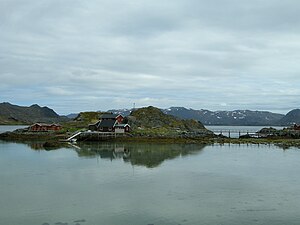
Honningsvåg is the northernmost city/town in mainland Norway. It is located in Nordkapp Municipality in Finnmark county. Honningsvåg was declared a city in 1996, despite its small population.
Nordvågen
Village in Northern Norway, Norway
Distance: Approx. 3465 meters
Latitude and longitude: 70.98027778,26.03194444
Nordvågen is a small fishing village in Nordkapp Municipality in Finnmark county, Norway. The village is located on the eastern coast of the island of Magerøya about 3 kilometres (1.9 mi) northeast of the town of Honningsvåg, along the Porsangerfjorden. The abandoned village of Kjelvik lies about 3 kilometres (1.9 mi) northeast of Nordvågen.
Honningsvåg Airport
Airport in Finnmark, Norway
Distance: Approx. 2658 meters
Latitude and longitude: 71.00972222,25.98361111
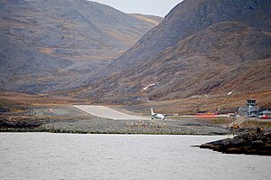
Honningsvåg Airport, Valan (Norwegian: Honningsvåg lufthavn, Valan; IATA: HVG, ICAO: ENHV) is a regional airport serving Honningsvåg in Nordkapp Municipality, Norway. The airport is located at Valan, on the south side of Skipsfjorden, 4 kilometers (2+1⁄2 miles) north of the town, and 31 km (19+1⁄2 mi) from the North Cape. The airport has a 880-by-30-meter (2,887 by 98 ft) asphalt runway which is operated by the state-owned Avinor.
Kjelvik
Abandoned village in Northern Norway, Norway
Distance: Approx. 6339 meters
Latitude and longitude: 71.00194444,26.1125
Kjelvik is an abandoned fishing village in Nordkapp Municipality in Finnmark county, Norway. It is located on the island of Magerøya, about 5 kilometres (3.1 mi) northeast of the town of Honningsvåg and about 3.5 kilometres (2.2 mi) northeast of the village of Nordvågen. It sits near the mouth of the Porsangerfjorden.

Honningsvåg Tunnel
Road tunnel in Nordkapp Municipality, Finnmark county, Norway
Distance: Approx. 2661 meters
Latitude and longitude: 70.9851,25.8697
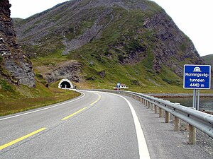
The Honningsvåg Tunnel (Norwegian: Honningsvågtunnelen) is a road tunnel on the island of Magerøya in Nordkapp Municipality in Finnmark county, Norway. It is located slightly north of the undersea North Cape Tunnel, and it is part of the European route E69 highway. The 4,443-metre (14,577 ft) long tunnel opened in 1999, at the same time as the North Cape Tunnel, as part of a large project to connect the mainland of Norway to North Cape.
Kamøyvær
Village in Northern Norway, Norway
Distance: Approx. 6641 meters
Latitude and longitude: 71.0487,25.9055
Kamøyvær is a fishing village in Nordkapp Municipality in Finnmark county, Norway. The village lies along the Kamøyfjorden on the east side of the island of Magerøya, about 10 kilometres (6.2 mi) northwest of the town of Honningsvåg. It sits at the end of a cul-de-sac road, the Norwegian County Road 172.
Valan, Nordkapp
Village in Northern Norway, Norway
Distance: Approx. 2463 meters
Latitude and longitude: 71.00888889,25.97777778
Valan is a small coastal village on the island of Magerøya in Nordkapp Municipality in Finnmark county in far northern Norway. Valan is the site of Honningsvåg Airport, the local airport for the town of Honningsvåg which is located about 2 kilometres (1.2 mi) south of Valan. The European route E69 highway runs through the village.
Store Kamøya, Nordkapp
Island in Norway
Distance: Approx. 6832 meters
Latitude and longitude: 71.0515,25.9504
Store Kamøya (Northern Sami: Gáhpesuolu) is a small island in Nordkapp Municipality in Finnmark county, Norway. It is located off the eastern coast of the large island of Magerøya where the Kamøyfjorden splits into the Duksfjorden and Skipsfjorden. It lies just to the southeast of the island of Lille Kamøya and to the east of the fishing village of Kamøyvær, helping to shelter the latter's harbour from the open sea.

Skipsfjorden, Magerøya
Fjord in Nordkapp, Norway
Distance: Approx. 2671 meters
Latitude and longitude: 71.0138,25.9281
Skipsfjorden (Northern Sami: Skiipavuotna) is the southern arm of the Kamøyfjorden, a fjord on the eastern side of the island of Magerøya in Nordkapp Municipality in Finnmark county, Norway. The mouth of the fjord spans between the Skipsfjordneset headland in the northwest and Selvågklubben peninsula in the southeast. The fjord extends about 4 kilometres (2.5 mi) to the west, and the island of Trollholmen is located near the end of the fjord.

Honningsvåg Church
Church in Finnmark, Norway
Distance: Approx. 1930 meters
Latitude and longitude: 70.977979,25.9791389
Honningsvåg Church (Norwegian: Honningsvåg kirke) is a parish church of the Church of Norway in Nordkapp Municipality in Finnmark county, Norway. It is located in the town of Honningsvåg on the eastern end of the island of Magerøya. It is one of the churches for the Nordkapp parish which is part of the Hammerfest prosti (deanery) in the Diocese of Nord-Hålogaland.
Weather in this IP's area
light rain
4 Celsius
-3 Celsius
4 Celsius
4 Celsius
981 hPa
87 %
981 hPa
981 hPa
10000 meters
14.4 m/s
280 degree
75 %
09:33:42
12:28:17


