Country:
 Belgium
Region:
City:
Latitude and Longitude:
Time Zone:
Postal Code:
IP information under different IP Channel
ip-api
Country
Region
City
ASN
Time Zone
ISP
Blacklist
Proxy
Latitude
Longitude
Postal
Route
IPinfo
Country
Region
City
ASN
Time Zone
ISP
Blacklist
Proxy
Latitude
Longitude
Postal
Route
MaxMind
Country
Region
City
ASN
Time Zone
ISP
Blacklist
Proxy
Latitude
Longitude
Postal
Route
Luminati
Country
BEASN
Time Zone
Europe/Brussels
ISP
NTT Belgium SA
Latitude
Longitude
Postal
db-ip
Country
Region
City
ASN
Time Zone
ISP
Blacklist
Proxy
Latitude
Longitude
Postal
Route
ipdata
Country
Region
City
ASN
Time Zone
ISP
Blacklist
Proxy
Latitude
Longitude
Postal
Route
Popular places and events near this IP address
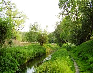
Woluwe
Stream in Brussels, Belgium
Distance: Approx. 1530 meters
Latitude and longitude: 50.88333333,4.45
The Woluwe (French: [wɔlywe]; Dutch: [ˈʋoːlyʋə]) is a stream that goes through several municipalities in the south-east and east of Brussels, Belgium, and is a right tributary of the Senne in Vilvoorde. The Kleine (little) Maalbeek is a tributary of the Woluwe in Kraainem. Many ponds formed along the stream over time, among which the Mellaerts Ponds still exist.

Diegem
Distance: Approx. 52 meters
Latitude and longitude: 50.894232,4.435623
Diegem is a town in the municipality of Machelen, in the province of Flemish Brabant, Belgium. Diegem's postal code is 1831. The official language of Diegem is Dutch, as in the rest of Flanders.

Haren, Belgium
Neighbourhood in Brussels, Belgium
Distance: Approx. 1279 meters
Latitude and longitude: 50.89194444,4.41833333
Haren (French: [aʁɛn]; Dutch: [ˈɦaːrə(n)] ; sometimes written Haeren in French) is a former municipality of Brussels, Belgium, that was merged into the City of Brussels in 1921. It is an outlying part of the municipality and is situated at the north-eastern edge of the Brussels-Capital Region, bordering Machelen outside the boundary. Haren's postal code is 1130.

Vilvoorde Viaduct
Distance: Approx. 2392 meters
Latitude and longitude: 50.91333333,4.42138889
The Vilvoorde viaduct is part of the R0 Brussels beltway. Built as the last piece to close the Brussels beltway in 1977, it allowed the beltway to be opened for traffic on December 29 the same year. It crosses several roads, the river Zenne, the Brussels–Scheldt Maritime Canal, a railroad and the former Renault assembly plant.

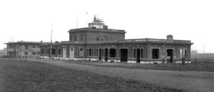
NATO headquarters
Headquarters of the North Atlantic Treaty Organization in Haren, Brussels, Belgium
Distance: Approx. 1831 meters
Latitude and longitude: 50.87916667,4.425
The NATO headquarters is the political and administrative center of the North Atlantic Treaty Organization (NATO). After previous locations in London and Paris, it has been headquartered in Brussels since 1967, in a complex in Haren, part of the City of Brussels, along the Boulevard Léopold III/Leopold III-laan. The staff at the headquarters is composed of national delegations of NATO member states and includes civilian and military liaison offices and officers or diplomatic missions and diplomats of partner countries, as well as the International Staff (IS) and International Military Staff (IMS) filled from serving members of the armed forces of member states.
Haren Airport
Military airfield and civil airport in Belgium
Distance: Approx. 1943 meters
Latitude and longitude: 50.88027778,4.41916667
Haren Airport or Evere Airfield is a former military airfield and civil airport in Brussels, Belgium. Located in Brussels' city section of Haren and adjacent municipality of Evere, it was established by the German Empire in 1914 and lasted until the early 1950s when it was closed. Meanwhile it had been replaced by nearby Melsbroek airfield that Nazi Germany had established in World War II, which developed into the current Brussels Airport.
NATO Standardization Office
NATO agency responsible for standardization activities
Distance: Approx. 2224 meters
Latitude and longitude: 50.87615556,4.42201111
The NATO Standardization Office (NSO) (former NATO Standardization Agency, NSA; French: Bureau OTAN de normalisation) is a NATO agency created in 1951 to handle standardization activities for NATO. The NSA was formed through the merger of the Military Agency for Standardization and the Office for NATO Standardization. During the Agency Reforms, the NSA was transformed to the NATO Standardization Office (NSO) on 1 July 2014, headed by the Director of the NATO Standardization Office (DNSO). The NSO is composed of military and civilian staff that was created to be responsible for standardization for both the Military Committee and the North Atlantic Council It also provides standardization to NATO members military forces, with the goal of interoperability between member nations.

Confédération Interalliée des Sous-Officiers de Réserve
Distance: Approx. 2224 meters
Latitude and longitude: 50.87615556,4.42201111
The Confédération Interalliée des Sous-Officiers de Réserve (CISOR), until 2013 also known as Association Européenne des Sous-Officiers de Réserve (AESOR), is the parent organisation of the national European NCO Reserve Corps within the NATO and also international. Currently CISOR consists 14 countries under the presidential lead of Germany. This non-profit organisation was founded 1 June 1963.

Haren railway station (Brussels)
Railway station in Brussels, Belgium
Distance: Approx. 1307 meters
Latitude and longitude: 50.88861111,4.41972222
Haren railway station (French: Gare de Haren; Dutch: Station Haren) is a railway station on line 26 of the Belgian railway network. It is situated in Haren, part of the City of Brussels in the Brussels-Capital Region, Belgium. The train services are operated by the National Railway Company of Belgium (NMBS/SNCB).

Haren-South railway station
Railway station in Brussels, Belgium
Distance: Approx. 1626 meters
Latitude and longitude: 50.88919444,4.41438889
Haren-South railway station (French: Gare de Haren-Sud, Dutch: Station Haren-Zuid) is a railway station on line 36 of the Belgian railway network. It is situated in Haren, part of the City of Brussels in the Brussels-Capital Region, Belgium. The train services are operated by the National Railway Company of Belgium (NMBS/SNCB).
Haren Prison
Prison in Brussels, Belgium
Distance: Approx. 880 meters
Latitude and longitude: 50.89796,4.42541
Haren Prison (French: Prison de Haren, Dutch: Gevangenis van Haren) is a new prison in Haren in the north-eastern part of Brussels, Belgium. It is 9.8 kilometres (6.1 mi) from Brussels-South railway station, and is near Brussels Airport, Vilvoorde Viaduct and the planned Uplace shopping centre in Machelen in Flemish Brabant, just outside Brussels. It is said to be the largest prison complex ever built in Belgium, and is intended to replace the old Saint-Gilles Prison, Forest Prison and Berkendael Prison.

NATO Star
Sculpture in Brussels
Distance: Approx. 1833 meters
Latitude and longitude: 50.87883333,4.42611111
The NATO Star is a sculpture situated in the court of honor of the North Atlantic Treaty Organization's (NATO) headquarters in Brussels, Belgium. The sculpture was unveiled in 1971. It symbolises the bond between Europe and North America, and is inspired by the alliance's flag, which was introduced in 1953.
Weather in this IP's area
broken clouds
13 Celsius
13 Celsius
13 Celsius
13 Celsius
1002 hPa
88 %
1002 hPa
999 hPa
10000 meters
5.08 m/s
12.74 m/s
230 degree
80 %
07:52:32
19:07:10