Country:
 Norway
Region:
City:
Latitude and Longitude:
Time Zone:
Postal Code:
IP information under different IP Channel
ip-api
Country
Region
City
ASN
Time Zone
ISP
Blacklist
Proxy
Latitude
Longitude
Postal
Route
IPinfo
Country
Region
City
ASN
Time Zone
ISP
Blacklist
Proxy
Latitude
Longitude
Postal
Route
MaxMind
Country
Region
City
ASN
Time Zone
ISP
Blacklist
Proxy
Latitude
Longitude
Postal
Route
Luminati
Country
NORegion
15
City
volda
ASN
Time Zone
Europe/Oslo
ISP
Telenor Norge AS
Latitude
Longitude
Postal
db-ip
Country
Region
City
ASN
Time Zone
ISP
Blacklist
Proxy
Latitude
Longitude
Postal
Route
ipdata
Country
Region
City
ASN
Time Zone
ISP
Blacklist
Proxy
Latitude
Longitude
Postal
Route
Popular places and events near this IP address

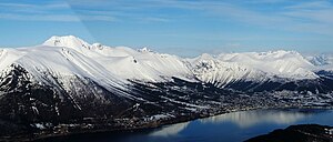
Ørsta
Municipality in Møre og Romsdal, Norway
Distance: Approx. 749 meters
Latitude and longitude: 62.20027778,6.13222222
is a municipality in Møre og Romsdal county, Norway. It is part of the Sunnmøre region of Western Norway. The administrative centre of the municipality is the village of Ørsta.

Ørsta–Volda Airport
Airport in Ørsta, Norway
Distance: Approx. 3674 meters
Latitude and longitude: 62.17861111,6.07583333
Ørsta–Volda Airport (Nynorsk: Ørsta–Volda lufthamn; IATA: HOV, ICAO: ENOV) is a regional airport situated at Hovden (Hovdebygda), in Ørsta, Norway, midway between the towns of Ørsta and Volda. The airport features a 1,070-metre (3,510 ft) asphalt runway aligned 06/24. Services are provided by Widerøe using their de Havilland Canada Dash 8 as a public service obligation.
Saudehornet
Distance: Approx. 3677 meters
Latitude and longitude: 62.2356,6.1425
Saudehornet or Sauehornet is a mountain that is located 3 kilometres (1.9 mi) north of the village of Ørsta in the municipality of Ørsta, Møre og Romsdal, Norway. The 1,303-metre (4,275 ft) is a very popular, though steep, destination for skiing in the Sunnmørsalpene range. It is located just north of the European route E39 highway, about 5 kilometres (3.1 mi) north of the Ørsta–Volda Airport, Hovden, and about 7 kilometres (4.3 mi) south of the village of Vartdal.
Volda University College
Institution of higher education in Norway
Distance: Approx. 6746 meters
Latitude and longitude: 62.1476,6.0741
Volda University College (Norwegian: Høgskulen i Volda or HVO) is one of the no-tuition state institutions in the system of higher education in Norway. It is located in the town of Volda, Møre og Romsdal county, Norway.

Volda (village)
Village in Western Norway, Norway
Distance: Approx. 6969 meters
Latitude and longitude: 62.146,6.0711
Volda is the administrative centre of the municipality of Volda, in Møre og Romsdal county, Norway. The village is located on the northeastern shore of the Voldsfjorden, just less than 10 kilometres (6.2 mi) south of the village of Ørsta. The 3.77-square-kilometre (930-acre) village has a population (2018) of 6,433.

Ørsta (village)
Town in Western Norway, Norway
Distance: Approx. 659 meters
Latitude and longitude: 62.1998,6.129
Ørsta is the administrative centre of the municipality of Ørsta, Møre og Romsdal, Norway. The village is located at the innermost part of the Ørstafjorden, surrounded by the Sunnmørsalpene mountains. The village of Volda is located about 10 kilometres (6.2 mi) southwest of Ørsta.

Ørstafjorden
Distance: Approx. 3595 meters
Latitude and longitude: 62.2083,6.0518
Ørstafjorden is a fjord in the municipality of Ørsta, Møre og Romsdal, Norway. The 10-kilometre (6.2 mi) long fjord runs from the village of Ørsta to the Vartdalsfjorden. The fjord is about 2 kilometres (1.2 mi) wide and the deepest point in the fjord reaches 172 metres (564 ft) below sea level.
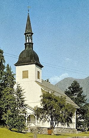
Ørsta Church
Church in Møre og Romsdal, Norway
Distance: Approx. 689 meters
Latitude and longitude: 62.2001997,6.13062322
Ørsta Church (Norwegian: Ørsta kyrkje) is a parish church of the Church of Norway in the municipality of Ørsta in Møre og Romsdal county, Norway. It is located in the village of Ørsta. It is the church for the Ørsta parish which is part of the Søre Sunnmøre prosti (deanery) in the Diocese of Møre.

Volda Church
Church in Møre og Romsdal, Norway
Distance: Approx. 7078 meters
Latitude and longitude: 62.14565528,6.06737137
Volda Church (Norwegian: Volda kyrkje; Voldskyrkja) is a parish church of the Church of Norway in the municipality of Volda in Møre og Romsdal county, Norway. It is located in the village of Volda, along the northeastern shore of the Voldsfjorden. It is the church for the Volda parish as well as the seat of the Søre Sunnmøre prosti (deanery) in the Diocese of Møre.
Søre Sunnmøre District Court
District court in Volda, Norway
Distance: Approx. 6802 meters
Latitude and longitude: 62.147106,6.073846
Søre Sunnmøre District Court (Norwegian: Søre Sunnmøre tingrett) was a district court in Møre og Romsdal county, Norway. The court was based in the village of Volda. The court existed until 2021.

Brudavoll Farm
Museum in Ørsta, Sunnmøre, Norway
Distance: Approx. 4266 meters
Latitude and longitude: 62.187295,6.19422889
The Brudavoll Farm (Norwegian: Brudavolltunet) is a museum in the municipality of Ørsta in the Sunnmøre region of Western Norway. The museum is an old farm that was purchased for museum purposes in 1958. The farm is located about 5 kilometers (3.1 mi) from the center of Ørsta.

Sivert Aarflot Museum
Distance: Approx. 6586 meters
Latitude and longitude: 62.16237222,6.03083611
The Sivert Aarflot Museum (Norwegian: Sivert Aarflot-museet) is a division of the Sunnmøre Museum Foundation in Norway. The museum is named after Sivert Aarflot (1759–1817), who among other things started the first rural printing shop in Norway. The Sivert Aarflot Museum has a permanent exhibition in the museum building at the farm in Ekset in the municipality of Volda, where Sivert Aarflot lived.
Weather in this IP's area
clear sky
8 Celsius
8 Celsius
7 Celsius
10 Celsius
1009 hPa
81 %
1009 hPa
1004 hPa
10000 meters
08:29:03
18:11:50