Country:
Region:
City:
Latitude and Longitude:
Time Zone:
Postal Code:
IP information under different IP Channel
ip-api
Country
Region
City
ASN
Time Zone
ISP
Blacklist
Proxy
Latitude
Longitude
Postal
Route
Luminati
Country
ASN
Time Zone
Europe/London
ISP
Daisy Corporate Services Trading Ltd
Latitude
Longitude
Postal
IPinfo
Country
Region
City
ASN
Time Zone
ISP
Blacklist
Proxy
Latitude
Longitude
Postal
Route
db-ip
Country
Region
City
ASN
Time Zone
ISP
Blacklist
Proxy
Latitude
Longitude
Postal
Route
ipdata
Country
Region
City
ASN
Time Zone
ISP
Blacklist
Proxy
Latitude
Longitude
Postal
Route
Popular places and events near this IP address

Ealing Broadway station
London Underground and railway station
Distance: Approx. 279 meters
Latitude and longitude: 51.5147,-0.3017
Ealing Broadway is a major single-level interchange station located in Ealing, in the London Borough of Ealing, West London for London Underground services and also Elizabeth line services on the National Rail Great Western Main Line. On the Underground, it is one of three western termini of the District line, the next station being Ealing Common, and it is also one of two western termini of the Central line, the next station being West Acton. On the National Rail network, it is a through-station on the Great Western Main Line, 5 miles 56 chains (9.2 km) down the line from London Paddington, between Acton Main Line and West Ealing.
Pitzhanger Manor
English country house
Distance: Approx. 380 meters
Latitude and longitude: 51.51109722,-0.30722778
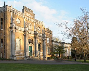
Pitzhanger Manor is an English country house famous as the home of neoclassical architect, Sir John Soane. Built between 1800 and 1804 in what is now Walpole Park Ealing, to the west of London), the Regency Manor is a rare and spectacular example of a building designed, built and lived in by Sir John Soane himself. Soane intended it as a domestic space to entertain guests in, as well as a family home for a dynasty of architects, starting with his sons.
Municipal Borough of Ealing
Distance: Approx. 395 meters
Latitude and longitude: 51.513,-0.3076
Ealing was a local government district from 1863 to 1965 around the town of Ealing which formed part of the built up area of London until 1965, where it became part of Greater London.

2001 Ealing bombing
2001 bombing in Ealing Broadway, West London, England
Distance: Approx. 200 meters
Latitude and longitude: 51.514,-0.3021
The 2001 Ealing bombing was a terrorist attack in Ealing Broadway, London, England by the Real Irish Republican Army (RIRA), a splinter group of the Provisional Irish Republican Army (PIRA) that opposed the Good Friday Agreement.

Ealing Jazz Club
Distance: Approx. 252 meters
Latitude and longitude: 51.51444444,-0.3025
Ealing Jazz Club was a music venue in Ealing, west London, England, which opened in 1959. It became London's first regular blues venue, with performances by the Alexis Korner and Cyril Davies band Blues Incorporated. Now commonly referred to as the Ealing Blues Club, the venue is now a nightclub called The Red Room.

London College of Music
Music school, part of the University of West London
Distance: Approx. 411 meters
Latitude and longitude: 51.51,-0.3068
London College of Music (LCM) is a music school in London, England. It is one of eight separate schools that make up the University of West London.

Drama Studio London
Distance: Approx. 373 meters
Latitude and longitude: 51.5094,-0.305
Drama Studio London (often abbreviated as DSL) is a British drama school in London. It is accredited by the Federation of Drama Schools. The principal is Emma Lucia Hands.

Ealing Grove
Distance: Approx. 94 meters
Latitude and longitude: 51.51194444,-0.30333333
Ealing Grove was a mansion and estate in Ealing, Middlesex, west London, England. It was adjacent to the Ealing House estate, but distinct from it, and stood amongst trees. The house was converted into an Italianate villa by the younger Joseph Gulston in the 1770s.

Ealing Broadway Centre
Shopping mall in London, England
Distance: Approx. 70 meters
Latitude and longitude: 51.512,-0.303
The Ealing Broadway Centre, currently branded as simply Ealing Broadway, is a shopping centre in Ealing, west London. Located on The Broadway close by Ealing Broadway station, the centre consists of 85 units both indoor and a courtyard part outdoor. It was opened on 7 March 1985 by The Queen and the complex includes the town square and the Ealing Central Library.

Ealing Town Hall
Municipal building in London, England
Distance: Approx. 395 meters
Latitude and longitude: 51.513,-0.3076
Ealing Town Hall is a municipal building in New Broadway, Ealing, London, England. It is a Grade II listed building.

Parafia Ealing
Distance: Approx. 218 meters
Latitude and longitude: 51.514,-0.3008
Polish Roman Catholic Church of Our Lady Mother of the Church also known as Parafia Ealing is a Polish Catholic church in Ealing. It was formerly a Methodist church from 1892, until 2020. Polish catholics formerly worshipped in Saint Matthew’s, Ealing Common, before settling in this church building.
Old Town Hall, Ealing
Municipal building in London, England
Distance: Approx. 227 meters
Latitude and longitude: 51.5142,-0.3014
The Old Town Hall is a former municipal building in the Mall in Ealing, London. The building, which is currently used as a branch of National Westminster Bank, is a Grade II listed building.
Weather in this IP's area
mist
10 Celsius
10 Celsius
8 Celsius
11 Celsius
1022 hPa
90 %
1022 hPa
1017 hPa
5000 meters
1.03 m/s
190 degree
100 %
07:02:20
16:27:16


