Country:
Region:
City:
Latitude and Longitude:
Time Zone:
Postal Code:
IP information under different IP Channel
ip-api
Country
Region
City
ASN
Time Zone
ISP
Blacklist
Proxy
Latitude
Longitude
Postal
Route
Luminati
Country
Region
63
City
havlickuvbrod
ASN
Time Zone
Europe/Prague
ISP
Edera Group a.s.
Latitude
Longitude
Postal
IPinfo
Country
Region
City
ASN
Time Zone
ISP
Blacklist
Proxy
Latitude
Longitude
Postal
Route
db-ip
Country
Region
City
ASN
Time Zone
ISP
Blacklist
Proxy
Latitude
Longitude
Postal
Route
ipdata
Country
Region
City
ASN
Time Zone
ISP
Blacklist
Proxy
Latitude
Longitude
Postal
Route
Popular places and events near this IP address

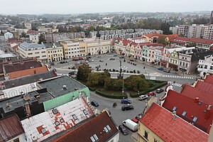
Havlíčkův Brod
Town in Vysočina, Czech Republic
Distance: Approx. 1153 meters
Latitude and longitude: 49.60777778,15.58083333
Havlíčkův Brod (Czech pronunciation: [ˈɦavliːtʃkuːv ˈbrot], until 1945 Německý Brod; German: Deutschbrod) is a town in Havlíčkův Brod District in the Vysočina Region of the Czech Republic. It has about 24,000 inhabitants. The historic town centre is well preserved and is protected by law as an urban monument zone.

Břevnice
Municipality in Vysočina, Czech Republic
Distance: Approx. 2534 meters
Latitude and longitude: 49.63138889,15.6125
Břevnice (Czech pronunciation: [ˈbr̝ɛvɲɪtsɛ]; German: Hrzebnicz) is a municipality and village in Havlíčkův Brod District in the Vysočina Region of the Czech Republic. It has about 200 inhabitants. Břevnice lies approximately 5 kilometres (3 mi) north-east of Havlíčkův Brod, 28 km (17 mi) north of Jihlava, and 99 km (62 mi) south-east of Prague.
Dolní Krupá (Havlíčkův Brod District)
Municipality in Vysočina, Czech Republic
Distance: Approx. 4939 meters
Latitude and longitude: 49.66055556,15.60305556
Dolní Krupá (Czech pronunciation: [ˈdolɲiː ˈkrupaː]; German: Unter Kraupen) is a municipality and village in Havlíčkův Brod District in the Vysočina Region of the Czech Republic. It has about 400 inhabitants. Dolní Krupá lies approximately 7 kilometres (4 mi) north of Havlíčkův Brod, 30 km (19 mi) north of Jihlava, and 98 km (61 mi) south-east of Prague.

Knyk
Municipality in Vysočina, Czech Republic
Distance: Approx. 3258 meters
Latitude and longitude: 49.64694444,15.57861111
Knyk is a municipality and village in Havlíčkův Brod District in the Vysočina Region of the Czech Republic. It has about 400 inhabitants. Knyk lies approximately 5 kilometres (3 mi) north of Havlíčkův Brod, 28 km (17 mi) north of Jihlava, and 97 km (60 mi) south-east of Prague.

Kyjov (Havlíčkův Brod District)
Municipality in Vysočina, Czech Republic
Distance: Approx. 3101 meters
Latitude and longitude: 49.62944444,15.62333333
Kyjov is a municipality and village in Havlíčkův Brod District in the Vysočina Region of the Czech Republic. It has about 200 inhabitants. Kyjov lies approximately 5 kilometres (3 mi) north-east of Havlíčkův Brod, 27 km (17 mi) north of Jihlava, and 101 km (63 mi) south-east of Prague.
Pohled (Havlíčkův Brod District)
Municipality in Vysočina, Czech Republic
Distance: Approx. 4873 meters
Latitude and longitude: 49.60361111,15.64805556
Pohled is a municipality and village in Havlíčkův Brod District in the Vysočina Region of the Czech Republic. It has about 700 inhabitants. Pohled lies approximately 6 kilometres (4 mi) east of Havlíčkův Brod, 24 km (15 mi) north of Jihlava, and 103 km (64 mi) south-east of Prague.

Veselý Žďár
Municipality in Vysočina, Czech Republic
Distance: Approx. 4842 meters
Latitude and longitude: 49.63972222,15.52611111
Veselý Žďár is a municipality and village in Havlíčkův Brod District in the Vysočina Region of the Czech Republic. It has about 600 inhabitants. Veselý Žďár lies approximately 6 kilometres (4 mi) north-west of Havlíčkův Brod, 28 km (17 mi) north of Jihlava, and 94 km (58 mi) south-east of Prague.

Ždírec (Havlíčkův Brod District)
Municipality in Vysočina, Czech Republic
Distance: Approx. 4349 meters
Latitude and longitude: 49.62916667,15.64194444
Ždírec (German: Sehrlenz) is a municipality and village in Havlíčkův Brod District in the Vysočina Region of the Czech Republic. It has about 100 inhabitants. Ždírec lies approximately 6 kilometres (4 mi) north-east of Havlíčkův Brod, 27 km (17 mi) north of Jihlava, and 102 km (63 mi) south-east of Prague.

Havlíčkův Brod Airfield
Airport in the Czech Republic
Distance: Approx. 3418 meters
Latitude and longitude: 49.59722222,15.54916667
Havlíčkův Brod Airfield (Czech: Letiště Havlíčkův Brod) (ICAO: LKHB) is a public aerodrome (and not a public international airport) with civilian traffic. It is situated approximately 1 kilometre (1 mi) southwest of Havlíčkův Brod in the Vysočina Region of the Czech Republic. The aerodrome is plentifully used for sport flying and sightseeing flights above the Bohemian-Moravian Highlands.

Havlíčkův Brod Brewery
Brewery in the Czech Republic
Distance: Approx. 1017 meters
Latitude and longitude: 49.6102,15.5766
The town brewery of Havlíčkův Brod (Havlíčkobrodský pivovar) produces Rebel brand beer.
FC Slovan Havlíčkův Brod
Football club
Distance: Approx. 1675 meters
Latitude and longitude: 49.60496528,15.57232694
FC Slovan Havlíčkův Brod is a Czech football club located in Havlíčkův Brod. It currently plays in the Czech Fourth Division. The club was founded in 1911 and celebrated its centenary in 2011.
Havlíčkův Brod railway station
Railway station in Havlíčkův Brod, Czech Republic
Distance: Approx. 2135 meters
Latitude and longitude: 49.59888889,15.58805556
Havlíčkův Brod is a railway station in Havlíčkův Brod in Vysočina Region of the Czech Republic.
Weather in this IP's area
broken clouds
5 Celsius
4 Celsius
4 Celsius
6 Celsius
1026 hPa
87 %
1026 hPa
972 hPa
10000 meters
1.66 m/s
1.67 m/s
279 degree
79 %
07:09:41
16:15:10


