Country:
 Germany
Region:
City:
Latitude and Longitude:
Time Zone:
Postal Code:
IP information under different IP Channel
ip-api
Country
Region
City
ASN
Time Zone
ISP
Blacklist
Proxy
Latitude
Longitude
Postal
Route
IPinfo
Country
Region
City
ASN
Time Zone
ISP
Blacklist
Proxy
Latitude
Longitude
Postal
Route
MaxMind
Country
Region
City
ASN
Time Zone
ISP
Blacklist
Proxy
Latitude
Longitude
Postal
Route
Luminati
Country
DEASN
Time Zone
Europe/Berlin
ISP
area-7 IT-Services GmbH
Latitude
Longitude
Postal
db-ip
Country
Region
City
ASN
Time Zone
ISP
Blacklist
Proxy
Latitude
Longitude
Postal
Route
ipdata
Country
Region
City
ASN
Time Zone
ISP
Blacklist
Proxy
Latitude
Longitude
Postal
Route
Popular places and events near this IP address
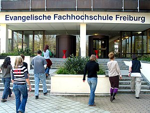
Protestant University for Applied Sciences Freiburg
Distance: Approx. 1518 meters
Latitude and longitude: 47.9975,7.80388889
The Protestant University of Applied Sciences Freiburg (German name: Evangelische Hochschule Freiburg (EH)) is a university of social work, diakonia and religious education. It is a confessional, state-approved university located in Freiburg. The responsible body is the Protestant regional church of Baden (Evangelische Landeskirche in Baden).

International Solar Energy Society
Distance: Approx. 2811 meters
Latitude and longitude: 47.977318,7.826739
The International Solar Energy Society (ISES) is a global organization for promoting the development and utilization of renewable energy. ISES is a UN-accredited NGO headquartered in Freiburg im Breisgau, Germany. Prof.

Sankt Georgen (Freiburg)
Distance: Approx. 1115 meters
Latitude and longitude: 47.98111111,7.80416667
Freiburg-St.Georgen (Low Alemannic: Sant-Jerge) is a district of the German city Freiburg and consists of three villages: Uffhausen, Wendlingen and Sankt Georgen itself. Sankt Georgen became a part of Freiburg in 1937. It is bordered by the Schönberg in the South, Merzhausen to the South-East, the Wiehre to the East, Haslach to the North-West and the Rieselfeld to the North-East.
Haslach (Freiburg)
Distance: Approx. 2178 meters
Latitude and longitude: 47.99055556,7.82027778
Haslach, incorporated into the city on 1 January 1890, is one of the Western districts of Freiburg im Breisgau. After the demerging of Weingarten the district is made up out of the boroughs 611 Haslach-Egerten, 612 Haslach-Gartenstadt, 613 Haslach-Schildacker and 614 Haslach-Haid. Its population is 20,939 (2020).
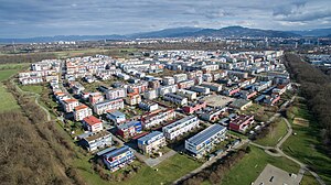
Rieselfeld
Stadtteil of Freiburg im Breisgau in Baden-Württemberg, Germany
Distance: Approx. 1368 meters
Latitude and longitude: 47.99888889,7.79166667
Rieselfeld is a city quarter (Stadtteil) in Freiburg im Breisgau. It is located in the western part of the city and borders the nature reserve Freiburger Rieselfeld in the west, right next to a little zoo called Tiergehege Mundenhof, Opfinger Straße in the south and Besançonallee in the east. The industrial area Haid is part of the Sankt Georgen district and is located to the south of Rieselfeld, while the district Weingarten is situated to the east of Rieselfeld.

Freiburger Verkehrs AG
Distance: Approx. 763 meters
Latitude and longitude: 47.9924,7.7971
Freiburger Verkehrs AG, also known as VAG Freiburg or just VAG, is the municipal transport company of the city of Freiburg im Breisgau in Germany and is responsible for operating the local tram network. It is a member of the Regio-Verkehrsverbund Freiburg (RVF), a transport association that co-ordinates public transport in the city of Freiburg and the neighboring districts of Emmendingen and Breisgau-Hochschwarzwald. Furthermore VAG owns 50% of the shares in the Breisgau S-Bahn, the other 50% are with SWEG. The company operates a regional railway network on DB Netz AG and SWEG owned tracks.

Sonnenschiff
Building in Freiburg, Baden-Württemberg, Germany
Distance: Approx. 3068 meters
Latitude and longitude: 47.975,7.829
Sonnenschiff (lit. 'sun ship') is a large integrated office and retail building in Freiburg im Breisgau, Germany. It was built in 2004 in the city's Vauban quarter as part of the Solar Settlement at Schlierberg. Sonnenschiff was designed by the architect Rolf Disch (who also built the Heliotrope building) and generates four times more energy than it uses.
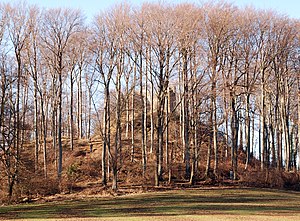
Schneeburg
Castle ruin in Germany
Distance: Approx. 2938 meters
Latitude and longitude: 47.96055556,7.79805556
Schneeburg is a castle ruin between Ebringen and Freiburg, Germany. The ruins are at an altitude of 516 metres (1693 feet) on the western summit of Schönberg.

Vauban, Freiburg
Distance: Approx. 2740 meters
Latitude and longitude: 47.97583333,7.82472222
Vauban (German pronunciation: [voˈbãː]) is a neighbourhood (Stadtteil) to the south of the town centre in Freiburg, Germany. It was built as "a sustainable model district" on the site of a former French military base named after Sébastien Le Prestre de Vauban, the 17th century French Marshal who built fortifications in Freiburg while the region was under French rule. Construction began in 1998, and the first two residents arrived in 2001.

Jennetal
Distance: Approx. 2716 meters
Latitude and longitude: 47.9623,7.7884
The Jennetal (the suffix -tal means dale) is a valley cut in the Schönberg mountain and also the name of a nature reserve, where it's located.
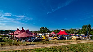
Zelt-Musik-Festival
Music festival in Freiburg, Germany
Distance: Approx. 2620 meters
Latitude and longitude: 48.0089,7.7804
The Zelt-Musik-Festival (ZMF) has taken place every June and July since 1983 in Freiburg im Breisgau, Germany. It lasts three weeks and counts up to 120,000 visitors each year. The program is very broad.

Betzenhausen
Quarter of Freiburg in Baden-Württemberg, Germany
Distance: Approx. 3054 meters
Latitude and longitude: 48.00833333,7.81666667
Betzenhausen is a quarter in the west of Freiburg im Breisgau, Germany. It consists of the statistical districts Alt-Betzenhausen and Betzenhausen-Bischofslinde. Neighbouring districts are Mooswald to the north, Stühlinger to the east, Weingarten to the south and Lehen to the west.
Weather in this IP's area
broken clouds
14 Celsius
14 Celsius
13 Celsius
15 Celsius
1014 hPa
72 %
1014 hPa
986 hPa
10000 meters
2.68 m/s
4.92 m/s
1 degree
70 %
07:33:50
19:00:14