Country:
 Cyprus
Region:
City:
Latitude and Longitude:
Time Zone:
Postal Code:
IP information under different IP Channel
ip-api
Country
Region
City
ASN
Time Zone
ISP
Blacklist
Proxy
Latitude
Longitude
Postal
Route
IPinfo
Country
Region
City
ASN
Time Zone
ISP
Blacklist
Proxy
Latitude
Longitude
Postal
Route
MaxMind
Country
Region
City
ASN
Time Zone
ISP
Blacklist
Proxy
Latitude
Longitude
Postal
Route
Luminati
Country
CYRegion
04
City
famagusta
ASN
Time Zone
Asia/Famagusta
ISP
Arinet Security & Internet Consultancy Ltd
Latitude
Longitude
Postal
db-ip
Country
Region
City
ASN
Time Zone
ISP
Blacklist
Proxy
Latitude
Longitude
Postal
Route
ipdata
Country
Region
City
ASN
Time Zone
ISP
Blacklist
Proxy
Latitude
Longitude
Postal
Route
Popular places and events near this IP address

Famagusta
City and municipality in eastern Cyprus
Distance: Approx. 759 meters
Latitude and longitude: 35.125,33.94166667
Famagusta, also known by several other names, is a city on the east coast of the areas in the state of Turkish Republic of Northern Cyprus. It is located east of the capital, Nicosia, and possesses the deepest harbour of the island. During the Middle Ages (especially under the maritime republics of Genoa and Venice), Famagusta was the island's most important port city and a gateway to trade with the ports of the Levant, from where the Silk Road merchants carried their goods to Western Europe.

Eastern Mediterranean University
Public university in Northern Cyprus
Distance: Approx. 4537 meters
Latitude and longitude: 35.145716,33.907079
The Eastern Mediterranean University (EMU; Turkish: Doğu Akdeniz Üniversitesi) is a public university in Northern Cyprus. It was established in 1979 under the leadership of Onay Fadıl Demirciler (then Undersecretary of the Ministry of Education) as a higher-education institution of technology for Turkish Cypriots. In 1986, it was converted to a state university.

Varosha, Famagusta
Place in Famagusta District, Cyprus
Distance: Approx. 1611 meters
Latitude and longitude: 35.11083333,33.95361111
Varosha (Greek: Βαρώσια, romanized: Varósia, locally [vaˈɾoʃa]; Turkish: Maraş [maˈɾaʃ] or Kapalı Maraş) is the southern quarter of Famagusta, a de jure territory of Cyprus, currently under the control of Northern Cyprus. Varosha has a population of 226 in the 2011 Northern Cyprus census. The area of Varosha is 6.19 km2 (2.39 sq mi).
GSE Stadium
Football stadium in Famagusta, Cyprus
Distance: Approx. 764 meters
Latitude and longitude: 35.11861111,33.95305556
The Evagoras Gymnastic Association Stadium (GSE Stadium) (Gymnastikos Syllogos Evagoras, Greek: Γυμναστικός Σύλλογος Ευαγόρας) is a football stadium located in Famagusta, Cyprus and was the home ground of Anorthosis and Nea Salamina. The stadium remains abandoned and in bad condition since 1974 when Turkey invaded the island of Cyprus and occupied 37.6% of it including the city of Famagusta. After the summer of 1974, Anorthosis used many football stadiums all around Cyprus like Dasaki Stadium, Aradippou Municipal Stadium, Paralimni Stadium, Tsirion Stadium, old GSZ Stadium, and new GSZ Stadium.

Lala Mustafa Pasha Mosque
Building in Famagusta, Cyprus
Distance: Approx. 667 meters
Latitude and longitude: 35.1249,33.94268
The Lala Mustafa Pasha Mosque (Turkish: Lala Mustafa Paşa Camii), originally known as the Cathedral of Saint Nicholas and later as the Saint Sophia (Ayasofya) Mosque of Mağusa, is the largest medieval building in Famagusta, Cyprus. Built between 1298 and c. 1400, it was consecrated as a Catholic cathedral in 1328.
Strovilia
Place in Akrotiri and Dhekelia, United Kingdom
Distance: Approx. 5410 meters
Latitude and longitude: 35.09611111,33.90222222
Strovilia (Greek: Στροβίλια), (Turkish: Akyar) is a small Cypriot village located at the border of the de facto Turkish Republic of Northern Cyprus (TRNC) with the British Sovereign Base Area (SBA) of Dhekelia. It is the site of a Green Line crossing between Cyprus and Northern Cyprus. Some of Strovilia lies in Northern Cyprus, some in UK's SBA. The Cyprus UN buffer zone boundaries are defined as the cease fire lines of 16 August 1974.

Ganchvor monastery
Church in de jure Cyprus, de facto Northern Cyprus
Distance: Approx. 1267 meters
Latitude and longitude: 35.1274,33.9364
Ganchvor Sourp Asdvadzadzin (Armenian: Կանչուոր Սուրբ Աստուածածին) is the Armenian Apostolic church in Famagusta, Cyprus.
Famagusta Namık Kemal High School
Public secondary school in Famagusta, Northern Cyprus
Distance: Approx. 1141 meters
Latitude and longitude: 35.11777778,33.94111111
Famagusta Namık Kemal High School is a secondary school located in Famagusta, Northern Cyprus. It was founded in 1944. Many famous Cypriots have graduated from Famagusta Namık Kemal High School.
Siege of Famagusta
Battle during the Ottoman-Venetian wars
Distance: Approx. 759 meters
Latitude and longitude: 35.125,33.94166667
The siege of Famagusta happened in Venetian-controlled Famagusta, the last Christian possession in Cyprus. Famagusta fell to the Ottomans in August 1571 after a siege that lasted nearly a year.

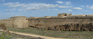
Port of Famagusta
Port
Distance: Approx. 928 meters
Latitude and longitude: 35.13333333,33.95
The Port of Famagusta is a seaport in Famagusta, Cyprus. There is a free zone ("Famagusta Free Zone") in the port. The port is under the de facto control of Northern Cyprus.
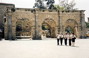
Palazzo del Provveditore
Royal palace in Famagusta
Distance: Approx. 821 meters
Latitude and longitude: 35.1245,33.941
Palazzo del Provveditore, commonly known as the Venetian Palace, was a royal palace in Famagusta, originally built by the Lusignan Kings of Cyprus. It was later modified and used as the governor's official residence during the Venetian rule. The central sections of the palace have been completely destroyed, with only its grand facade and back courtyard walls being left.
Cyprus West University
University in Northern Cyprus
Distance: Approx. 1441 meters
Latitude and longitude: 35.1242,33.9342
Cyprus West University (CWU; Turkish: Kıbrıs Batı Üniversitesi, commonly referred to as KIBÜ) is a non-profit university located in Famagusta, Northern Cyprus was established in 2015. Cyprus West University has five faculties, three schools, and 20 different undergraduate and associate programs are offered in English and Turkish Languages. Cyprus West University is accredited by YÖK, Turkish Republic Higher Education Board and YÖDAK, The Higher Education Planning, Evaluation, Accreditation and coordination Council of Northern Cyprus, and approved by TRNC Ministry of National Education and Culture.
Weather in this IP's area
clear sky
24 Celsius
24 Celsius
24 Celsius
24 Celsius
1018 hPa
48 %
1018 hPa
1018 hPa
10000 meters
8.09 m/s
7.44 m/s
7 degree
06:53:36
18:04:19