185.134.180.104 - IP Lookup: Free IP Address Lookup, Postal Code Lookup, IP Location Lookup, IP ASN, Public IP
Country:
Region:
City:
Location:
Time Zone:
Postal Code:
IP information under different IP Channel
ip-api
Country
Region
City
ASN
Time Zone
ISP
Blacklist
Proxy
Latitude
Longitude
Postal
Route
Luminati
Country
ASN
Time Zone
America/Chicago
ISP
TWDX
Latitude
Longitude
Postal
IPinfo
Country
Region
City
ASN
Time Zone
ISP
Blacklist
Proxy
Latitude
Longitude
Postal
Route
IP2Location
185.134.180.104Country
Region
massachusetts
City
somerville
Time Zone
America/New_York
ISP
Language
User-Agent
Latitude
Longitude
Postal
db-ip
Country
Region
City
ASN
Time Zone
ISP
Blacklist
Proxy
Latitude
Longitude
Postal
Route
ipdata
Country
Region
City
ASN
Time Zone
ISP
Blacklist
Proxy
Latitude
Longitude
Postal
Route
Popular places and events near this IP address

Somerville, Massachusetts
City in Massachusetts, United States
Distance: Approx. 43 meters
Latitude and longitude: 42.3875,-71.1
Somerville ( SUM-ər-vil) is a city located directly to the northwest of Boston, and north of Cambridge, in Middlesex County, Massachusetts, United States. As of the 2020 United States Census, the city had a total population of 81,045 people. With an area of 4.12 square miles (10.7 km2), the city has a density of 19,671/sq mi (7,595/km2), making it the most densely populated municipality in New England and the 19th most densely populated incorporated municipality in the country.

Somerville High School (Massachusetts)
Public secondary school in Somerville, MA, United States
Distance: Approx. 216 meters
Latitude and longitude: 42.387,-71.097
Somerville High School is a public, four-year high school in Somerville, Massachusetts, United States. The school offers a wide selection of classes and vocational programs. Classes offered include music, performing arts, journalism, TV and media production, ceramics, and computer applications.

First Universalist Church (Somerville, Massachusetts)
Historic church in Massachusetts, United States
Distance: Approx. 118 meters
Latitude and longitude: 42.38781944,-71.1009
The First Universalist Church is a historic Universalist Church building at 125 Highland Avenue in Somerville, Massachusetts. The Romanesque church building was built between 1916 and 1923 to a design by Ralph Adams Cram, and is the only example of his work in Somerville. The building was listed on the National Register of Historic Places in 1989.

First Unitarian Church (Somerville, Massachusetts)
Historic church in Massachusetts, United States
Distance: Approx. 162 meters
Latitude and longitude: 42.38755556,-71.10147222
The former First Unitarian Church is a historic church building at 130 Highland Avenue in Somerville, Massachusetts. The stone church was built in 1894 for a Unitarian congregation. It was designed by Hartwell & Richardson and is a good example of Richardsonian Romanesque design.

George Loring House
Historic house in Massachusetts, United States
Distance: Approx. 255 meters
Latitude and longitude: 42.3861,-71.09716111
The George Loring House is a historic house at 76 Highland Avenue in Somerville, Massachusetts. The 2+1⁄2-story Shingle style wood-frame house was built c. 1895 for George F. Loring, the architect who designed it.

Samuel Gaut House
Historic house in Massachusetts, United States
Distance: Approx. 214 meters
Latitude and longitude: 42.38813889,-71.102
The Samuel Gaut House is a historic house in Somerville, Massachusetts. The 2+1⁄2-story wood-frame house was built c. 1855 for Samuel Gaut, a baker, and is a well-preserved example of a typical Italianate house.

Susan Russell House
Historic house in Massachusetts, United States
Distance: Approx. 286 meters
Latitude and longitude: 42.39004167,-71.10058611
The Susan Russell House is a historic house in Somerville, Massachusetts. The 1.5-story Greek Revival cottage is estimated to have been built in the 1830s, based on a stylistic analysis. It is a rare survivor of a style that was once common in Somerville.

Walter S. and Melissa E. Barnes House
Historic house in Massachusetts, United States
Distance: Approx. 252 meters
Latitude and longitude: 42.38791944,-71.10253056
The Walter S. and Melissa E. Barnes House is a historic house at 140 Highland Avenue in Somerville, Massachusetts. Built about 1890, it is one of the city's least-altered examples of Queen/Stick style Victorian architecture. It was for many years home to Robert Luce, a one-term Lieutenant Governor of Massachusetts.

Somerville City Hall
United States historic place
Distance: Approx. 117 meters
Latitude and longitude: 42.3872,-71.09818889
The Somerville City Hall (which formerly served as Somerville High School) is a historic municipal building at 93 Highland Avenue in Somerville, Massachusetts. Built in 1852 and enlarged several times, it has served as the city's first high school, first public library, and only city hall. The building was added to the National Register of Historic Places in 1989.

Gilman Square station
Light rail station in Somerville, Massachusetts, US
Distance: Approx. 227 meters
Latitude and longitude: 42.38792,-71.09677
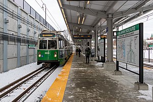
Gilman Square station is a light rail station on the Massachusetts Bay Transportation Authority (MBTA) Green Line located at Gilman Square in Somerville, Massachusetts. The accessible station has a single island platform serving the two tracks of the Medford Branch. It opened on December 12, 2022, as part of the Green Line Extension (GLX), which added two northern branches to the Green Line, and is served by the E branch.
Timeline of Somerville, Massachusetts
Distance: Approx. 43 meters
Latitude and longitude: 42.3875,-71.1
The following is a timeline of the history of Somerville, Massachusetts, US.

Gilman Square
Neighborhood in Somerville, Massachusetts
Distance: Approx. 301 meters
Latitude and longitude: 42.3881,-71.0959
Gilman Square is a neighborhood in the area around Central Hill in Somerville, Massachusetts, United States. Historic Gilman Square is at the junction of Medford, Pearl, and Marshall streets and has been a small commercial center since the mid 19th-century. With the development of the Gilman Square Green Line station, city planning documents consider the area within a rough ten-minute walk of the new station to be part of the Gilman Square neighborhood.
Weather in this IP's area
overcast clouds
9 Celsius
7 Celsius
6 Celsius
11 Celsius
1014 hPa
94 %
1014 hPa
1012 hPa
10000 meters
3.6 m/s
170 degree
100 %