185.132.164.160 - IP Lookup: Free IP Address Lookup, Postal Code Lookup, IP Location Lookup, IP ASN, Public IP
Country:
Region:
City:
Location:
Time Zone:
Postal Code:
IP information under different IP Channel
ip-api
Country
Region
City
ASN
Time Zone
ISP
Blacklist
Proxy
Latitude
Longitude
Postal
Route
Luminati
Country
ASN
Time Zone
Europe/Madrid
ISP
Aire Networks Del Mediterraneo Sl Unipersonal
Latitude
Longitude
Postal
IPinfo
Country
Region
City
ASN
Time Zone
ISP
Blacklist
Proxy
Latitude
Longitude
Postal
Route
IP2Location
185.132.164.160Country
Region
valenciana, comunidad
City
babel
Time Zone
Europe/Madrid
ISP
Language
User-Agent
Latitude
Longitude
Postal
db-ip
Country
Region
City
ASN
Time Zone
ISP
Blacklist
Proxy
Latitude
Longitude
Postal
Route
ipdata
Country
Region
City
ASN
Time Zone
ISP
Blacklist
Proxy
Latitude
Longitude
Postal
Route
Popular places and events near this IP address

Alicante
Municipality in Valencian Community, Spain
Distance: Approx. 2525 meters
Latitude and longitude: 38.34527778,-0.48305556
Alicante (, also UK: , US: ; Spanish: [aliˈkante]; Valencian: Alacant [alaˈkant]; officially: Alicante / Alacant) is a city and municipality in the Valencian Community, Spain. It is the capital of the province of Alicante and a historic Mediterranean port. The population of the city was 337,482 as of 2020, the second-largest in the Valencian Community.

European Union Intellectual Property Office
European Union agency
Distance: Approx. 2672 meters
Latitude and longitude: 38.314702,-0.51824
The European Union Intellectual Property Office (EUIPO) (French: Office de l'Union européenne pour la propriété intellectuelle) is a decentralised agency of the EU responsible for the registration of EU-wide unitary trade marks and industrial design rights. These exist alongside the intellectual property rights of individual EU member states, so the agency also works to harmonise EU-wide and national registration processes. Other responsibilities include the administration of the rights of certain products in the EU to carry geographical indications.
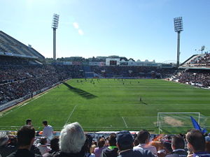
Estadio José Rico Pérez
Distance: Approx. 2659 meters
Latitude and longitude: 38.35722222,-0.4925
Estadio José Rico Pérez is a multi-purpose stadium in Alicante, Spain. It is currently used mostly for football matches, being home to Hércules CF. It also hosted World Cup matches when Spain organized the event in 1982. With a capacity of 24,704 seats, it is the 25th-largest stadium in Spain and the 4th-largest in the Valencian Community.

Alacantí
Comarca in Valencian Community, Spain
Distance: Approx. 2421 meters
Latitude and longitude: 38.34611111,-0.48472222
Alacantí (Valencian: [alakanˈti], Spanish: [alakanˈti]), also known in Spanish as Campo de Alicante and Comarca de Alicante, is a comarca in the Valencian Community, Spain. It is bordered by the comarques of Marina Baixa and Alcoià to the north, Baix Vinalopó to the south and Vinalopó Mitjà to the west.
Pabellón Pedro Ferrándiz
Distance: Approx. 2265 meters
Latitude and longitude: 38.35402778,-0.49458333
Pabellón Pedro Ferrándiz is an arena, designed by Enric Miralles, in Alicante, Spain. Formerly named as Centro de Tecnificación de Alicante, it changed its name in honour to the Spanish basketball coach and member of the Basketball Hall of Fame Pedro Ferrándiz on 14 January 2014. The arena holds 5,425 people.

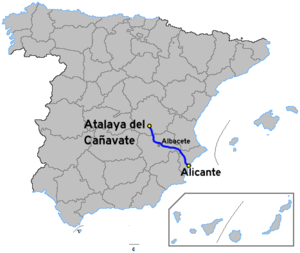
Autovía A-31
Motorway from Atalaya del Cañavate to Alicante (Spain)
Distance: Approx. 354 meters
Latitude and longitude: 38.33472222,-0.51055556
The Autovía A-31, also known as the Autovía de Alicante, is a highway in Spain. The road connects Madrid to Alicante. It starts at a junction with the Autovía A-3 at Alarcón and heads south east to Albacete.
Alicante railway station
Distance: Approx. 1531 meters
Latitude and longitude: 38.34444444,-0.49497222
Alicante Terminal (Valencian: Alacant Terminal) is the central railway station of Alicante, Spain. Commonly referred locally as the RENFE station, the station is part of Adif system, and is a terminal station. The station accommodates RENFE long-distance and medium-distance trains, and it is the origin of lines C-1 and C-3 of Cercanías Murcia/Alicante (suburban trains).

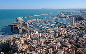
Port of Alicante
Port in Spain
Distance: Approx. 1905 meters
Latitude and longitude: 38.33694444,-0.48861111
The Port of Alicante is a seaport in Alicante, Spain on the Mediterranean Sea used for commercial and passenger traffic. The port is administered by the Port Authority of Alicante.
Concatedral de San Nicolás, Alicante
Roman Catholic co-cathedral in Alicante, Spain
Distance: Approx. 2576 meters
Latitude and longitude: 38.34541667,-0.4825
The Co-Cathedral of St. Nicholas of Bari (Valencian: Cocatedral de Sant Nicolau de Bari; Spanish: Concatedral de San Nicolás de Bari) is a Catholic co-cathedral located in Alicante, in the Valencian Community of Spain.

Gran Sol
Hotel in Alicante, Spain
Distance: Approx. 2479 meters
Latitude and longitude: 38.34388889,-0.48305556
Alicante Gran Sol (formerly Tryp Gran Sol, officially Hotel Alicante Gran Sol Affiliated by Meliá) is a skyscraper and hotel in Alicante, Spain. It is 97 meters tall and has 31 floors and belongs to the Spanish hotel group Meliá Hotels International. The hotel is the third tallest building in the city after Estudiotel Alicante (117 m) and El Barco (111 m).
Estudiotel Alicante
Skyscraper in Spain
Distance: Approx. 1891 meters
Latitude and longitude: 38.3445042,-0.4904419
Estudiotel Alicante (also Riscal) is a skyscraper and hotel in Alicante, Spain. It is located at Poeta Vila y Blanco Street 4 in 03003 postal area near Plaza de los Luceros. It is 117 metres (384 ft) high, with 35 floors.
Nazareth College, Alicante
Spanish college
Distance: Approx. 2637 meters
Latitude and longitude: 38.35990278,-0.49922222
Nazareth College, Alicante, is a Spanish college. It was initiated by the Society of Jesus in 1957 to tend to the educational and other needs of at-risk youth and their families in the community of Alicante, Spain.
Weather in this IP's area
few clouds
10 Celsius
10 Celsius
10 Celsius
12 Celsius
1029 hPa
88 %
1029 hPa
1026 hPa
10000 meters
2.57 m/s
320 degree
20 %


