Country:
 Netherlands
Region:
City:
Latitude and Longitude:
Time Zone:
Postal Code:
IP information under different IP Channel
ip-api
Country
Region
City
ASN
Time Zone
ISP
Blacklist
Proxy
Latitude
Longitude
Postal
Route
IPinfo
Country
Region
City
ASN
Time Zone
ISP
Blacklist
Proxy
Latitude
Longitude
Postal
Route
MaxMind
Country
Region
City
ASN
Time Zone
ISP
Blacklist
Proxy
Latitude
Longitude
Postal
Route
Luminati
Country
NLASN
Time Zone
Europe/Amsterdam
ISP
LeaseWeb Netherlands B.V.
Latitude
Longitude
Postal
db-ip
Country
Region
City
ASN
Time Zone
ISP
Blacklist
Proxy
Latitude
Longitude
Postal
Route
ipdata
Country
Region
City
ASN
Time Zone
ISP
Blacklist
Proxy
Latitude
Longitude
Postal
Route
Popular places and events near this IP address

Amsterdam Centraal station
Railway station in the Netherlands
Distance: Approx. 393 meters
Latitude and longitude: 52.37833333,4.9
Amsterdam Centraal station (Dutch: Station Amsterdam Centraal [staːˈɕɔn ˌɑmstərˈdɑm sɛnˈtraːl]; abbreviation: Asd) is the largest railway station in Amsterdam, North Holland, the Netherlands. A major international railway hub, it is used by 192,000 passengers a day, making it the second busiest railway station in the country after Utrecht Centraal and the most visited Rijksmonument of the Netherlands. National and international railway services at Amsterdam Centraal are provided by NS (Nederlandse Spoorwegen), the principal rail operator in the Netherlands.
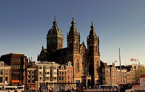
Basilica of Saint Nicholas, Amsterdam
Church in Amsterdam, Netherlands
Distance: Approx. 332 meters
Latitude and longitude: 52.37647222,4.90113889
The Basilica of Saint Nicholas (Dutch: Basiliek van de Heilige Nicolaas) is located in the Old Centre district of Amsterdam, Netherlands, very close to Amsterdam's main railway station. St, Nicholas is the patron saint of both the church and the city of Amsterdam. The basilica is the city's primary Roman Catholic church.
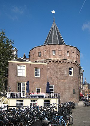
Schreierstoren
Tower in Amsterdam, the Netherlands
Distance: Approx. 264 meters
Latitude and longitude: 52.37644,4.90227
The Schreierstoren (English incorrectly translated as: Weeper's Tower or Tower of Tears), originally part of the medieval city wall of Amsterdam, the Netherlands, was built in the 15th century. It is located at the Prins Hendrikkade 94 in the city center of Amsterdam. It was the location from which Henry Hudson set sail on his journey to Northern America.

Conservatorium van Amsterdam
Dutch academy of music
Distance: Approx. 295 meters
Latitude and longitude: 52.37583333,4.90888889
The Conservatorium van Amsterdam (CvA) is a Dutch conservatoire of music located in Amsterdam. This school is the music division of the Amsterdam University of the Arts, the city's vocational university of arts. The Conservatorium van Amsterdam is the largest music academy in the Netherlands, offering programs in classical music, jazz, pop, electronic music, early music, music education, and opera.
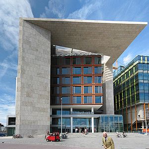
Openbare Bibliotheek Amsterdam
Distance: Approx. 223 meters
Latitude and longitude: 52.37583333,4.90722222
The Openbare Bibliotheek Amsterdam (Dutch pronunciation: [ˌoːpə(m)ˈbaːrə biblijoːˈteːk ˌɑmstərˈdɑm]; OBA; English: Amsterdam Public Library) is an organisation of public libraries in Amsterdam, Diemen and Ouder-Amstel in the Netherlands. The first library opened in 1919 at the Keizersgracht in Amsterdam. As of 2018, the OBA had 26 branch libraries, 177,000 members, and 1.3 million objects in its collection.

Oosterdokseiland
Neighborhood of Amsterdam in North Holland, Netherlands
Distance: Approx. 149 meters
Latitude and longitude: 52.37666667,4.90722222
Oosterdokseiland (Dutch: "Eastern Dock Island") is an island that forms a neighborhood of Amsterdam, Netherlands just to the east of Amsterdam Centraal railway station.
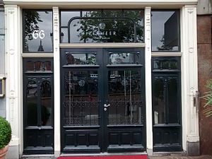
Restaurant Vermeer
Restaurant in Amsterdam, Netherlands
Distance: Approx. 361 meters
Latitude and longitude: 52.37654444,4.90063333
Restaurant Vermeer is a restaurant located in the NH Barbizon Palace hotel at the Prins Hendrikkade in Amsterdam, Netherlands. It is a fine dining restaurant that received its first Michelin star in 1993. It later lost and regained its star, then scored two stars in 2003.
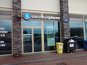
&moshik
Restaurant in Amsterdam, Netherlands
Distance: Approx. 110 meters
Latitude and longitude: 52.37662222,4.90538056
&moshik, formerly &samhoud places, was a fine-dining restaurant in Amsterdam, Netherlands. The restaurant was awarded two Michelin stars for 2013. However it owed this rating to the past performance of its head chef as the restaurant was opened too briefly for a thorough review.

Scheepvaarthuis
Distance: Approx. 372 meters
Latitude and longitude: 52.3744,4.9041
The Shipping House (Dutch: Scheepvaarthuis) is a building on the western tip of the Waalseiland near Amsterdam harbour that is one of the top 100 Dutch heritage sites and generally regarded as the first true example of the Amsterdam School, a style characterised by "expressive dynamism, lavish ornamentation and colourful embellishments". It is situated on the Prins Hendrikkade and was erected on the spot where Cornelis Houtman's first trip to the East Indies had begun in 1595. The first part was built 1913 - 1916 (during World War I); the second part was built 1926 -1928.
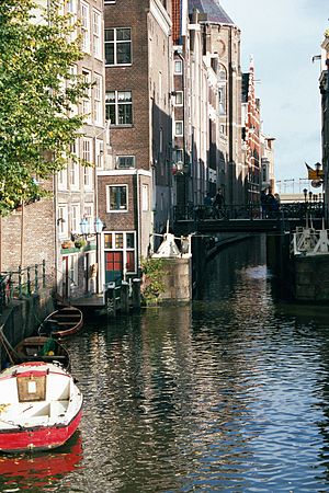
Oudezijds Kolk
Canal in Amsterdam
Distance: Approx. 330 meters
Latitude and longitude: 52.376169,4.901414
The Oudezijds Kolk is a short and narrow canal/lock in Amsterdam between the Oudezijds Voorburgwal and the Oosterdok.

Kromme Waal
Street in Amsterdam
Distance: Approx. 414 meters
Latitude and longitude: 52.374405,4.902537
The Kromme Waal is a street in Amsterdam between the Prins Hendrikkade and the Oude Waal.

Geldersekade
Canal in Amsterdam
Distance: Approx. 410 meters
Latitude and longitude: 52.374867,4.901612
The Geldersekade is a canal and a street in Amsterdam that connects the Nieuwmarkt with the Prins Hendrikkade. The Geldersekade is in the easternmost part of De Wallen, the red light district, and borders Chinatown.
Weather in this IP's area
few clouds
14 Celsius
14 Celsius
13 Celsius
15 Celsius
1017 hPa
86 %
1017 hPa
1017 hPa
10000 meters
6.17 m/s
210 degree
20 %
08:16:39
18:32:56