Country:
Region:
City:
Latitude and Longitude:
Time Zone:
Postal Code:
IP information under different IP Channel
ip-api
Country
Region
City
ASN
Time Zone
ISP
Blacklist
Proxy
Latitude
Longitude
Postal
Route
Luminati
Country
Region
lu
City
luxembourg
ASN
Time Zone
Europe/Luxembourg
ISP
JWE S.a r.l.
Latitude
Longitude
Postal
IPinfo
Country
Region
City
ASN
Time Zone
ISP
Blacklist
Proxy
Latitude
Longitude
Postal
Route
db-ip
Country
Region
City
ASN
Time Zone
ISP
Blacklist
Proxy
Latitude
Longitude
Postal
Route
ipdata
Country
Region
City
ASN
Time Zone
ISP
Blacklist
Proxy
Latitude
Longitude
Postal
Route
Popular places and events near this IP address

Duchy of Luxembourg
1353–1797 state of the Holy Roman Empire
Distance: Approx. 151 meters
Latitude and longitude: 49.61,6.13
The Duchy of Luxembourg (Dutch: Luxemburg; French: Luxembourg; German: Luxemburg; Luxembourgish: Lëtzebuerg) was a state of the Holy Roman Empire, the ancestral homeland of the noble House of Luxembourg. The House of Luxembourg became one of the most important political forces in the 14th century, competing against the House of Habsburg for supremacy in Central Europe. They would be the heirs to the Přemyslid dynasty in the Kingdom of Bohemia, succeeding to the Kingdom of Hungary and contributing four Holy Roman Emperors until their own line of male heirs came to an end and the House of Habsburg received the territories that the two Houses had originally agreed upon in the Treaty of Brünn in 1364.

Fortress of Luxembourg
Fortifications in and around Luxembourg City, Luxembourg, largely dismantled in 1867
Distance: Approx. 151 meters
Latitude and longitude: 49.61,6.13
The Fortress of Luxembourg (Luxembourgish: Festung Lëtzebuerg; French: Forteresse de Luxembourg; German: Festung Luxemburg) is the former fortifications of Luxembourg City, the capital of the Grand Duchy of Luxembourg, which were mostly dismantled beginning in 1867. The fortress was of great strategic importance for the control of the Left Bank of the Rhine, the Low Countries, and the border area between France and Germany. The fortifications were built gradually over nine centuries, from soon after the city's foundation in the tenth century until 1867.

Ville Haute
Quarter in Luxembourg City, Luxembourg
Distance: Approx. 83 meters
Latitude and longitude: 49.612,6.129
Ville Haute (Luxembourgish: Uewerstad, pronounced [ˈuəvɐʃtaːt] ; German: Oberstadt; lit. 'High City') is a quarter in central Luxembourg City, in southern Luxembourg. It is the historic center of Luxembourg City and is involved in its UNESCO World Heritage Site status. As of 31 December 2023, Ville Haute has a population of 3,544 inhabitants.

Place Guillaume II
Square in Luxembourg, Luxembourg
Distance: Approx. 82 meters
Latitude and longitude: 49.61083333,6.13027778
Place Guillaume II is a town square in Luxembourg City, in southern Luxembourg. The square is in the heart of Luxembourg's historic Ville Haute quarter. It is colloquially known as Knuedler, from the Luxembourgish language's word for "knot", referring to the knot in the belt worn by Franciscan friars.

Luxembourg City Hall
Distance: Approx. 144 meters
Latitude and longitude: 49.61020556,6.13045556
Luxembourg City Hall (Luxembourgish: Stadhaus Stad Lëtzebuerg; French: Hôtel de ville de Luxembourg) is the city hall of Luxembourg City, in southern Luxembourg. The city hall is the centre of local government, including being used as the private office of the Mayor of Luxembourg City. Because of its position in Luxembourg's capital, it regularly hosts foreign dignitaries.

Siege of Luxembourg (1684)
Siege during the War of the Reunions
Distance: Approx. 151 meters
Latitude and longitude: 49.61,6.13
The siege of Luxembourg, in which Louis XIV of France (husband of Maria Theresa of Spain) laid siege to the Spanish-controlled Fortress of Luxembourg from 27 April to 7 June 1684, was the most significant confrontation of the War of the Reunions between France and Spain. The action caused alarm among France's neighbours and resulted in the formation of the League of Augsburg in 1686. In the ensuing war France was forced to give up the duchy, which was returned to the Habsburgs by the Treaty of Ryswick in 1697.
Luxembourg Stock Exchange
Stock exchange located in Luxembourg
Distance: Approx. 176 meters
Latitude and longitude: 49.61257222,6.12794167
The Luxembourg Stock Exchange, LuxSE (French: Bourse de Luxembourg) is based in Luxembourg City at 35A boulevard Joseph II. The chairman of the board is Alain Kinsch and the chief executive officer is Julie Becker.

Cercle Municipal
Building in Luxembourg City, Luxembourg
Distance: Approx. 25 meters
Latitude and longitude: 49.61138889,6.12972222
The Cercle Municipal or Cercle Cité is a building in Luxembourg City, in southern Luxembourg. It is located at the eastern end of the Place d'Armes, in the historic central Ville Haute quarter of the city.

Place d'Armes (Luxembourg)
Square in Luxembourg
Distance: Approx. 42 meters
Latitude and longitude: 49.61111111,6.12888889
The Place d'Armes (Luxembourgish: Plëss d'Arem, or simply Plëss) is a square in Luxembourg City in the south of the Grand Duchy of Luxembourg. Centrally placed in the old town, it attracts large numbers of locals and visitors, especially in the summer months. It originally served as a parade ground for the troops defending the city.
Timeline of Luxembourg City
Distance: Approx. 60 meters
Latitude and longitude: 49.611667,6.13
The following is a timeline of the history of Luxembourg City, Luxembourg.

Palais du Mobilier Bonn Frères
Distance: Approx. 82 meters
Latitude and longitude: 49.61131,6.12827
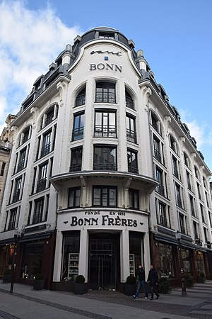
The Palais du Mobilier Bonn Frères (in English: Bonn Frères Furniture Showroom) is an Art Deco-style building in Luxembourg City, Luxembourg, designed by the architect Léon Bouvart (1883–1933) and built in 1925–26 by the contractor Achille Giorgetti for the Bonn family.

Old City of Luxembourg
UNESCO World Heritage Site
Distance: Approx. 55 meters
Latitude and longitude: 49.611,6.13
The Old City of Luxembourg (officially City of Luxembourg: its Old Quarters and Fortifications) is located mainly in Ville Haute (Uewerstad) in Luxembourg City, Grand Duchy of Luxembourg. The site was added to the UNESCO World Heritage list in 1994. The origin of the city was a fort built in the 10th century and had to be demolished in most parts in the 19th century (the casemates, the bastion and some walls still exist partly).
Weather in this IP's area
overcast clouds
7 Celsius
4 Celsius
5 Celsius
7 Celsius
1028 hPa
82 %
1028 hPa
990 hPa
10000 meters
3.6 m/s
10 degree
100 %
07:47:32
16:52:58
