Country:
Region:
City:
Latitude and Longitude:
Time Zone:
Postal Code:
IP information under different IP Channel
ip-api
Country
Region
City
ASN
Time Zone
ISP
Blacklist
Proxy
Latitude
Longitude
Postal
Route
Luminati
Country
Region
20
City
bialystok
ASN
Time Zone
Europe/Warsaw
ISP
KOBA Sp. z o.o.
Latitude
Longitude
Postal
IPinfo
Country
Region
City
ASN
Time Zone
ISP
Blacklist
Proxy
Latitude
Longitude
Postal
Route
db-ip
Country
Region
City
ASN
Time Zone
ISP
Blacklist
Proxy
Latitude
Longitude
Postal
Route
ipdata
Country
Region
City
ASN
Time Zone
ISP
Blacklist
Proxy
Latitude
Longitude
Postal
Route
Popular places and events near this IP address

Branicki Palace, Białystok
Distance: Approx. 451 meters
Latitude and longitude: 53.13055556,23.165
Branicki Palace (Polish: Pałac Branickich) is a historical edifice in Białystok, Poland. It was developed on the site of an earlier building in the first half of the 18th century by Jan Klemens Branicki, a wealthy Polish–Lithuanian Commonwealth hetman, into a residence suitable for a man whose ambition was to become king of Poland. The palace complex with gardens, pavilions, sculptures, outbuildings and other structures and the city with churches, city hall and monastery, all built almost at the same time according to French models was the reason why the city was known in the 18th century as Versailles de la Pologne (Versailles of Poland) and subsequently Versailles de la Podlachie (Versailles of Podlasie).

Medical University of Białystok
Public university in Białystok, Poland
Distance: Approx. 482 meters
Latitude and longitude: 53.13027778,23.16583333
The Medical University of Białystok (UMB; Polish: Uniwersytet Medyczny w Białymstoku) is a medical university located in Białystok, the capital of Podlaskie Voivodeship in northeastern Poland. The university is home to the Medical Department with a Division of Dentistry and a six-year M.D. program taught in English (English Division), Pharmacology Department with Medical Analytics Division, and a Nursing and Health Protection Department with divisions in Physiotherapy, Medical Rescue, Obstetrics, Public Health and Nursing.

Roman Catholic Archdiocese of Białystok
Roman Catholic archdiocese in Poland
Distance: Approx. 181 meters
Latitude and longitude: 53.13311944,23.16418889
The Archdiocese of Białystok (Latin: Bialostocen(sis); Belarusian: Беластоцкая архідыяцэзія, romanized: Biełastockaja archidyjacezia) is a Latin Church ecclesiastical territory or archdiocese of the Catholic Church in Podlaskie Voivodeship, Northeastern Poland. It is a metropolitan see with two suffragan dioceses. Its cathedral archiepiscopal see is Bazylika Archikatedralna Wniebowzięcia NMP, a minor basilica in the episcopal see of Białystok.

VI High School – King Sigismund Augustus
Liceum ogólnokształcące school in Białystok, Poland
Distance: Approx. 114 meters
Latitude and longitude: 53.134742,23.16699
VI High School – King Sigismund Augustus is a secondary school in the Bojary district of the city of Białystok in Poland.

Białystok Cathedral
Church in Białystok, Poland
Distance: Approx. 291 meters
Latitude and longitude: 53.1325,23.1627
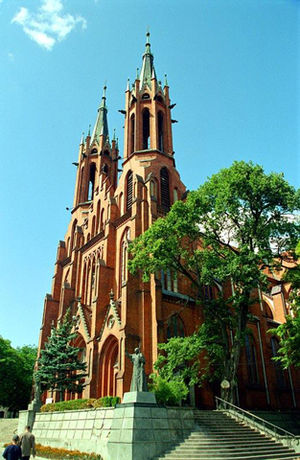
The Cathedral Basilica of the Assumption of the Blessed Virgin Mary (Polish: Bazylika archikatedralna Wniebowzięcia Najświętszej Maryi Panny w Białymstoku) also called Białystok Cathedral is a Roman Catholic cathedral in the city of Bialystok in Poland. It was designed by architect Józef Pius Dziekoński. The three-nave church is 90 meters long and can accommodate 9,500 worshipers.

Kościuszko Market Square
Square in Białystok, Poland
Distance: Approx. 340 meters
Latitude and longitude: 53.13194444,23.16277778
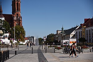
Kościuszko Square (Polish: Rynek Kościuszki) is the representative and central square of Białystok, capital of Podlaskie Voivodeship in north-eastern Poland.

Białystok Puppet Theatre
Puppet theatre in Białystok, Poland
Distance: Approx. 552 meters
Latitude and longitude: 53.1308,23.16
Bialystok Puppet Theatre (Polish: Białostocki Teatr Lalek), founded in 1953, is one of the oldest puppet theaters in Poland. Its repertoire consists mainly of puppetry-based adaptations of international literature, as well as children's entertainment.

Army Museum in Białystok
War museum in Kilińskiego Street, Bialystok
Distance: Approx. 304 meters
Latitude and longitude: 53.13194444,23.16638889
Army Museum in Białystok (Polish: Muzeum Wojska w Białymstoku) is a military museum located in Bialystok, the capital of Podlaskie Voivodeship in north-eastern Poland. It is the largest army museum in the region. First opened in 1968, since 1976 it has been operating as an independent museum unit with a macro-regional range.

Józef Poniatowski Park in Białystok
Park in Białystok, Poland
Distance: Approx. 558 meters
Latitude and longitude: 53.13,23.16861111
Old Park named after Prince Józef Poniatowski (Polish: Park Stary im. księcia Józefa Poniatowskiego) a naturalistic park in Białystok with modernist elements located in the Centrum District of Białystok, capital of Podlaskie Voivodeship. Established in the years 1895–1897 on the site of a former mill pond on the Biała River, part of the composition of the palace gardens with an area of 4.76 ha in Białystok, it was designed by Walerian Kronenberg in cooperation with Teodor Chrząński.
Chorszul Synagogue (Białystok)
Former synagogue in Białystok, Poland
Distance: Approx. 535 meters
Latitude and longitude: 53.133467,23.157519
The Chorszul Synagogue in Białystok (from Yiddish: Chóralna), known as the Zabłudowski Synagogue was a synagogue that was located in Białystok at Białówny Street (at those times Żydowska Street, in the centre of the new Jewish district.

Sienkiewicza Street, Białystok
Street in Białystok, Poland
Distance: Approx. 372 meters
Latitude and longitude: 53.1375,23.16805556
Sienkiewicza Street (Polish: Ulica Sienkiewicza) is a major street and a thoroughfare in Białystok running from the Kościuszko Market Square towards the Poleski Railway Station, running through Centrum, Sienkiewicza and Bojary districts.

Kilińskiego Street, Białystok
Distance: Approx. 265 meters
Latitude and longitude: 53.13222222,23.165
Jana Kilińskiego Street (Polish: Ulica Jana Kilińskiego) is a street in the central district of Białystok, running from Kościelna Street to Jana Pawła II Square. While being a relatively short street, it has a long-time importance in the city's history.
Weather in this IP's area
overcast clouds
3 Celsius
1 Celsius
2 Celsius
4 Celsius
1004 hPa
83 %
1004 hPa
988 hPa
10000 meters
2.24 m/s
4.92 m/s
202 degree
94 %
06:57:33
15:27:53