Country:
Region:
City:
Latitude and Longitude:
Time Zone:
Postal Code:
IP information under different IP Channel
ip-api
Country
Region
City
ASN
Time Zone
ISP
Blacklist
Proxy
Latitude
Longitude
Postal
Route
Luminati
Country
Region
dj
City
craiova
ASN
Time Zone
Europe/Bucharest
ISP
Digi Romania S.A.
Latitude
Longitude
Postal
IPinfo
Country
Region
City
ASN
Time Zone
ISP
Blacklist
Proxy
Latitude
Longitude
Postal
Route
db-ip
Country
Region
City
ASN
Time Zone
ISP
Blacklist
Proxy
Latitude
Longitude
Postal
Route
ipdata
Country
Region
City
ASN
Time Zone
ISP
Blacklist
Proxy
Latitude
Longitude
Postal
Route
Popular places and events near this IP address
Stadionul Ion Oblemenco (1967)
Football stadium in Romania
Distance: Approx. 1098 meters
Latitude and longitude: 44.31388889,23.78416667
Ion Oblemenco Stadium was a multi-purpose stadium in Craiova, Romania. It was used mostly for football matches and was the home ground of Universitatea Craiova. The stadium used to hold up to 25,252 people before it was demolished.

Carol I National College
Public school
Distance: Approx. 400 meters
Latitude and longitude: 44.31916667,23.79194444
The Carol I National College (Romanian: Colegiul Național Carol I din Craiova) is a high school located in central Craiova, Romania, on Ioan Maiorescu Street. It is one of the most prestigious secondary education institutions in Romania. Between 1947 and 1997 it operated under the name of Nicolae Bălcescu High School.

Multinational Brigade South-East (Romania)
Romanian Land Forces formation
Distance: Approx. 1344 meters
Latitude and longitude: 44.32975,23.79280556
The Multinational Brigade South-East (MN BDE SE) is an infantry brigade of the Romanian Land Forces. Until April 2017 the brigade was named 2nd Infantry Brigade "Rovine", but has since become one of Romania's contributions to NATO. The "Rovine" was deployed to Afghanistan and Iraq for peacekeeping missions.
Danube 21 Euroregion
Distance: Approx. 373 meters
Latitude and longitude: 44.31583333,23.80027778
Danube 21 Euroregion is a Euroregion located in Romania, Bulgaria and Serbia. The administrative center is Craiova.
Craiova Botanical Garden
Distance: Approx. 1066 meters
Latitude and longitude: 44.3243259,23.7866594
The Craiova Botanical Garden Alexandru Buia (Romanian: Grădina Botanică din Craiova), is a scientific organization where plant specimens are collected from different regions of the country and preserved as reference material, but also as study material for the students of University of Craiova. The garden occupies a large area in the center of the Craiova city, Romania, covering an area delimited by the streets Constantin Lecca (Comuna din Paris) - Obedeanu – Poporului – Renaşterii – Calea Severinului (N. Titulescu) – Iancu Jianu, at an altitude of about 99 m and it is located at latitude 44019’24.3”N and longitude 23047’17.9”E. It is also referred as a local park for the citizens of Craiova and a tourist destination in town.

Frații Buzești National College
Public school in Romania
Distance: Approx. 400 meters
Latitude and longitude: 44.31916667,23.79194444
The Frații Buzești National College (Romanian: Colegiul Național "Frații Buzești") is a high school located in central Craiova, Romania, at 5 Știrbei Vodă Street. It is one of the most prestigious secondary education institutions in Romania.
Elena Cuza National College (Craiova)
High school in Craiova, Romania
Distance: Approx. 376 meters
Latitude and longitude: 44.3199,23.7928
Elena Cuza National College (Romanian: Colegiul Național Elena Cuza) is a high school located at 12 Mihai Viteazul Sreeet, Craiova, Romania, teaching mainly foreign languages. Until 1944 and between 1970 and 1975, all classes were held in French.

Cathedral of Saint Demetrius, Craiova
Romanian Orthodox cathedral in Craiova, Romania
Distance: Approx. 492 meters
Latitude and longitude: 44.31516944,23.79195278
The Cathedral of Saint Demetrius (Romanian: Catedrala Sfântului Dumitru) is a Romanian Orthodox cathedral, see of the Metropolis of Oltenia. It is located at 14 Matei Basarab Street, Craiova, Romania, in the historic region of Oltenia. There was likely a church on the site by the 1490s, renovated in 1651 and, having fallen into disrepair, demolished in 1889.

Ion Oblemenco Stadium
Football stadium in Craiova, Romania
Distance: Approx. 1083 meters
Latitude and longitude: 44.314,23.7843
The Ion Oblemenco Stadium is a football stadium in Craiova, Romania. The all-seater stadium opened in 2017 and has a capacity of 30,983, the fourth largest football ground in Romania. It is in the immediate vicinity of the new Sala Polivalentă.
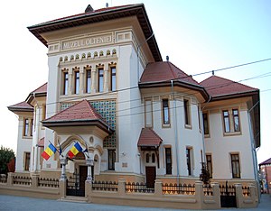
Museum of Oltenia
Museum in Craiova, Romania
Distance: Approx. 260 meters
Latitude and longitude: 44.31857,23.79354
The Museum of Oltenia (Romanian: Muzeul Olteniei) is a multidisciplinary museum in the city of Craiova, Oltenia, Romania. The archaeology section of museum was founded on 1 April 1915. The natural history section was founded in 1923 and the museum as it is structured today was established in 1928.
Craiova Art Museum
Distance: Approx. 327 meters
Latitude and longitude: 44.3191529,23.792917
The Craiova Art Museum (Romanian: Muzeul de Artă din Craiova) is an art museum in the city of Craiova, Oltenia, Romania. The museum is housed in the Constantin Mihail Palace, built from 1898 to 1907 according to the plans of French architect Paul Gottereau. The palace once belonged to Michael Constantine (1837–1908), a member of one of the richest families in Romania and is known as Jean Mihail Palace.

Craiova Prison
Penitentiary in Craiova, Romania
Distance: Approx. 1309 meters
Latitude and longitude: 44.3217,23.8123
Craiova Prison is a prison located in Craiova, Romania. The prison was originally located outside the city, but was later included within its boundaries. When it was built of stone and brick in 1894–1897, it was a modern, horseshoe-shaped structure on three levels.
Weather in this IP's area
clear sky
11 Celsius
9 Celsius
9 Celsius
11 Celsius
1031 hPa
44 %
1031 hPa
1019 hPa
10000 meters
2.24 m/s
100 degree
07:04:47
17:11:53


