Country:
 Denmark
Region:
City:
Latitude and Longitude:
Time Zone:
Postal Code:
IP information under different IP Channel
ip-api
Country
Region
City
ASN
Time Zone
ISP
Blacklist
Proxy
Latitude
Longitude
Postal
Route
IPinfo
Country
Region
City
ASN
Time Zone
ISP
Blacklist
Proxy
Latitude
Longitude
Postal
Route
MaxMind
Country
Region
City
ASN
Time Zone
ISP
Blacklist
Proxy
Latitude
Longitude
Postal
Route
Luminati
Country
DKRegion
82
City
abyhoj
ASN
Time Zone
Europe/Copenhagen
ISP
EG A/S
Latitude
Longitude
Postal
db-ip
Country
Region
City
ASN
Time Zone
ISP
Blacklist
Proxy
Latitude
Longitude
Postal
Route
ipdata
Country
Region
City
ASN
Time Zone
ISP
Blacklist
Proxy
Latitude
Longitude
Postal
Route
Popular places and events near this IP address
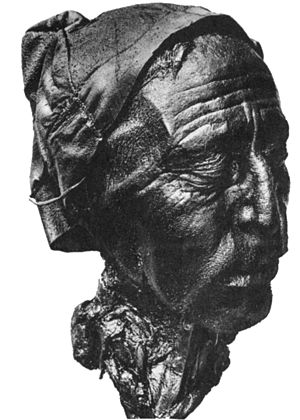
Tollund Man
Iron Age bog body from Denmark
Distance: Approx. 2622 meters
Latitude and longitude: 56.16444444,9.39277778
The Tollund Man (died 405–384 BCE) is a naturally mummified corpse of a man who lived during the 5th century BCE, during the period characterised in Scandinavia as the Pre-Roman Iron Age. He was found in 1950, preserved as a bog body, near Silkeborg on the Jutland peninsula in Denmark. The man's physical features were so well preserved that he was mistaken for a recent murder victim.

Central Denmark Region
Region of Denmark
Distance: Approx. 8932 meters
Latitude and longitude: 56.16666667,9.5
The Central Denmark Region (Danish: Region Midtjylland), or more directly translated as the Central Jutland Region and sometimes simply Mid-Jutland, is an administrative region of Denmark established on 1 January 2007 as part of the 2007 Danish municipal reform. The reform abolished the traditional counties (amter) and replaced them with five new administrative regions. At the same time, smaller municipalities were merged into larger units, cutting the total number of municipalities from 271 to 98.

Bølling Lake
Lake in Silkeborg Municipality, Denmark
Distance: Approx. 1013 meters
Latitude and longitude: 56.18055556,9.37222222
Bølling Lake (Danish: Bølling Sø), is a shallow lake of central Jutland in Denmark, slightly west of Silkeborg, between Kragelund and Engesvang. The lake is geologically important because it has been at the edge of the Pleistocene glacier. In the 1870s the lake was drained to accommodate the peat industry, giving science a chance to examine its bogs and historians and prehistorians a chance to examine the artifacts and human remains.

Storå (Denmark)
Distance: Approx. 9285 meters
Latitude and longitude: 56.1,9.3
The Storå (lit. 'Large Creek') or Storåen is Denmark's second longest river, spanning 104 kilometres (65 mi).

Skanderborg–Skjern railway line
Railway line in Jutland, Denmark
Distance: Approx. 2899 meters
Latitude and longitude: 56.15380556,9.378
The Skanderborg–Skjern railway line (Danish: Skanderborg–Skjern–banen) is a 111.9 km (69.5 mi) long standard gauge single track railway line in Denmark which runs between the cities of Skanderborg and Skjern in Central Jutland, Denmark. The railway opened in sections. The section from Skanderborg to Silkeborg opened in 1871, the section from Silkeborg to Herning in 1877, and the section from Herning to Skjern in 1881.
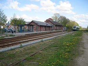
Bording railway station
Railway station in Jutland, Denmark
Distance: Approx. 5957 meters
Latitude and longitude: 56.14666667,9.27805556
Bording station is a railway station serving the railway town of Bording in Central Jutland, Denmark. Bording station is located on the Skanderborg–Skjern line. The station opened in 1877.

Engesvang railway station
Railway station in Jutland, Denmark
Distance: Approx. 1062 meters
Latitude and longitude: 56.16805556,9.35166667
Engesvang station is a railway station serving the railway town of Engesvang in Central Jutland, Denmark. Engesvang station is located on the Skanderborg–Skjern line. The station opened in 1877.

Karup River
River in Denmark
Distance: Approx. 5932 meters
Latitude and longitude: 56.19222222,9.26527778
Karup River (Danish: Karup Å; pronounced [ˈkʰɑːɔp.ɔˀ]) is a river in central Jutland, Denmark. Prior to 1970, it formed the border between the Viborg and Ringkjøbing counties. Karup River is Denmark's sixth largest river.
Weather in this IP's area
broken clouds
7 Celsius
5 Celsius
7 Celsius
8 Celsius
1013 hPa
100 %
1013 hPa
1005 hPa
10000 meters
3.6 m/s
200 degree
75 %
07:46:15
18:31:53