185.127.99.51 - IP Lookup: Free IP Address Lookup, Postal Code Lookup, IP Location Lookup, IP ASN, Public IP
Country:
Region:
City:
Location:
Time Zone:
Postal Code:
IP information under different IP Channel
ip-api
Country
Region
City
ASN
Time Zone
ISP
Blacklist
Proxy
Latitude
Longitude
Postal
Route
Luminati
Country
ASN
Time Zone
Europe/Copenhagen
ISP
TDC Holding A/S
Latitude
Longitude
Postal
IPinfo
Country
Region
City
ASN
Time Zone
ISP
Blacklist
Proxy
Latitude
Longitude
Postal
Route
IP2Location
185.127.99.51Country
Region
syddanmark
City
vejle
Time Zone
Europe/Copenhagen
ISP
Language
User-Agent
Latitude
Longitude
Postal
db-ip
Country
Region
City
ASN
Time Zone
ISP
Blacklist
Proxy
Latitude
Longitude
Postal
Route
ipdata
Country
Region
City
ASN
Time Zone
ISP
Blacklist
Proxy
Latitude
Longitude
Postal
Route
Popular places and events near this IP address

Golden Horns of Gallehus
Archaeological artefacts
Distance: Approx. 168 meters
Latitude and longitude: 55.71,9.53333333
The Golden Horns of Gallehus were two horns made of sheet gold, discovered in Gallehus, north of Møgeltønder in Southern Jutland, Denmark. The horns dated to the early 5th century, i.e. the beginning of the Germanic Iron Age.

Vejle County
Distance: Approx. 168 meters
Latitude and longitude: 55.71,9.53333333
Vejle County (Danish: Vejle Amt) is a former county (Danish: amt) on the east coast of the Jutland peninsula in southern Denmark. The county was abolished effective January 1, 2007, when it was divided between Region Midtjylland (i.e. Region Central Jutland) and Region of Southern Denmark.
Vejle
City in Jutland, Denmark
Distance: Approx. 833 meters
Latitude and longitude: 55.71666667,9.53333333
Vejle (Danish pronunciation: [ˈvɑjlə]) is a city in Denmark, in the southeast of the Jutland Peninsula at the head of Vejle Fjord, where the Vejle River and Grejs River and their valleys converge. It is the site of the councils of Vejle Municipality (kommune) and the Region of Southern Denmark. The city has a population of 61,706 (as of 1 January 2024) making it the ninth largest city in Denmark.
Vejle Municipality
Municipality in Southern Denmark, Denmark
Distance: Approx. 512 meters
Latitude and longitude: 55.705,9.5328
Vejle Municipality (Danish: Vejle Kommune) is a kommune in the Region of Southern Denmark on the Jutland peninsula in southeast Denmark. The municipality covers an area of 1,058.43 km2 (408.66 sq mi) (2013), and has a population of 121,696 (1. January 2024).

St. Nicolai Church (Vejle)
Church in Denmark
Distance: Approx. 213 meters
Latitude and longitude: 55.70747222,9.53472222
St. Nicolai Church (Danish: Sct. Nicolai Kirke) in Vejle, Denmark is a Lutheran church.

The Wave (Vejle)
Residential in Vejle, Denmark
Distance: Approx. 1295 meters
Latitude and longitude: 55.709392,9.556346
Bølgen (Danish "The Wave") is a modern residential building complex by the Skyttehus bay in Vejle, Denmark. It is inspired by the Sydney Opera House by Danish architect Jørn Utzon and the hilly landscape around Vejle Fjord. The Wave in Vejle is designed by Henning Larsen Architects and contains ultimately 105 luxury apartments distributed on 14,000 square metres (150,000 sq ft).

Vejle Museum of Art
Museum in Vejle, Jutland, Denmark
Distance: Approx. 833 meters
Latitude and longitude: 55.71666667,9.53333333
Vejle Museum of Art (Danish: Vejle Kunstmuseum) in the town centre of Vejle in southeastern Jutland, Denmark has Danish paintings and sculptures from classic modernism up until pre-COBRA on display. The museum is also home to a collection of Golden Age paintings from the Vejle area as well as a collection of drawings, e.g. 50 etchings by Rembrandt.
Vejle Library
Distance: Approx. 1021 meters
Latitude and longitude: 55.706275,9.520325
Vejle Library is the central library for the library system in the Billund, Esbjerg, Fredericia, Haderslev, Kolding, Middelfart, Sønderborg, Tønder, Varde, Vejen and Aabenraa municipalities of Denmark. The library is also the main library of the Vejle Municipality. Vejle libraries are organized with a main library in Vejle and central libraries in Børkop, Egtved, Give and Jelling.

Grejs River
River in Region of Southern Denmark, Denmark
Distance: Approx. 432 meters
Latitude and longitude: 55.70549,9.53439
Grejs River (Danish: Grejs Å) is an approximately 22-kilometre-long (14 mi) river in Vejle Municipality in Denmark. Its source is Fårup Lake, south of the village of Jelling. It starts by heading east through a tunnel valley, then turns south to run through Grejs Valley (Danish: Grejsdalen), the largest gorge in Denmark, until it reaches the city of Vejle.
Battle of Vejle
Distance: Approx. 833 meters
Latitude and longitude: 55.71666667,9.53333333
The Battle of Vejle was a battle of the Second Schleswig War that occurred on March 8, 1864, between the Austrian Empire and Denmark on the town of Vejle. The Austrian victory at the battle opened the way for the Evacuation of Fredericia and the Battle of Jasmund as well as solidifying Ludwig von Gablenz's military career.

Vejle railway station
Railway station in East Jutland, Denmark
Distance: Approx. 333 meters
Latitude and longitude: 55.70638889,9.53694444
Vejle railway station, also known as Vejle Transit Centre (Danish: Vejle Trafikcenter), is a railway station serving the town of Vejle in East Jutland, Denmark. The station is located on the Fredericia–Aarhus railway line from Fredericia to Aarhus and is the southeastern terminus of the Vejle–Holstebro railway line from Vejle to Holstebro. It offers direct InterCity services to Copenhagen, Hamburg, Struer, Aarhus and Aalborg as well as regional train services to Aarhus, Fredericia, Herning, and Struer.

Vejle Sygehus railway halt
Railway station in Vejle Municipality, Denmark
Distance: Approx. 639 meters
Latitude and longitude: 55.715,9.53694444
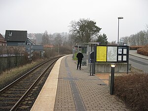
Vejle Sygehus railway halt is a railway halt serving the northern part of the city of Vejle in Jutland, Denmark, as well as the nearby hospital Vejle Sygehus. Vejle Sygehus railway halt is located on the Vejle–Holstebro railway line. The station opened in 1993 to serve the adjacent hospital Vejle Sygehus.
Weather in this IP's area
few clouds
5 Celsius
1 Celsius
5 Celsius
5 Celsius
1008 hPa
58 %
1008 hPa
1001 hPa
10000 meters
7.37 m/s
13.5 m/s
292 degree
19 %


