Country:
 Germany
Region:
City:
Latitude and Longitude:
Time Zone:
Postal Code:
IP information under different IP Channel
ip-api
Country
Region
City
ASN
Time Zone
ISP
Blacklist
Proxy
Latitude
Longitude
Postal
Route
IPinfo
Country
Region
City
ASN
Time Zone
ISP
Blacklist
Proxy
Latitude
Longitude
Postal
Route
MaxMind
Country
Region
City
ASN
Time Zone
ISP
Blacklist
Proxy
Latitude
Longitude
Postal
Route
Luminati
Country
DERegion
mv
City
sellin
ASN
Time Zone
Europe/Berlin
ISP
e.discom Telekommunikation GmbH
Latitude
Longitude
Postal
db-ip
Country
Region
City
ASN
Time Zone
ISP
Blacklist
Proxy
Latitude
Longitude
Postal
Route
ipdata
Country
Region
City
ASN
Time Zone
ISP
Blacklist
Proxy
Latitude
Longitude
Postal
Route
Popular places and events near this IP address

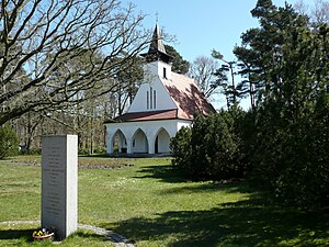
Sellin
Municipality in Mecklenburg-Vorpommern, Germany
Distance: Approx. 1346 meters
Latitude and longitude: 54.38333333,13.69166667
Sellin is a municipality on the Island of Rügen, in Mecklenburg-Vorpommern, Germany.

Lancken-Granitz
Municipality in Mecklenburg-Vorpommern, Germany
Distance: Approx. 2867 meters
Latitude and longitude: 54.36666667,13.63333333
Lancken-Granitz is a municipality in the Vorpommern-Rügen district, in Mecklenburg-Vorpommern, Germany. Near the villages of Lancken and Burtevitz are several megalith tombs from the Neolithic.
Baabe
Place in Mecklenburg-Vorpommern, Germany
Distance: Approx. 3549 meters
Latitude and longitude: 54.35,13.7
Baabe is a municipality in the Vorpommern-Rügen district in Mecklenburg-Vorpommern, Germany.

Mönchgut-Granitz
Distance: Approx. 3549 meters
Latitude and longitude: 54.35,13.7
Mönchgut-Granitz is an Amt in the district of Vorpommern-Rügen, in Mecklenburg-Vorpommern, Germany. The seat of the Amt is in Baabe.

Selliner See (Rügen)
Distance: Approx. 1615 meters
Latitude and longitude: 54.36555833,13.68656111
Selliner See (Rügen) is a lake in the Vorpommern-Rügen district in Mecklenburg-Vorpommern, Germany.
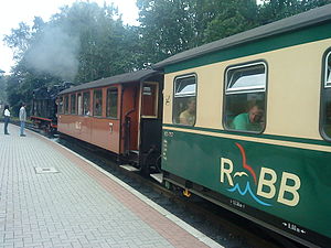
Rügen narrow-gauge railway
Distance: Approx. 3560 meters
Latitude and longitude: 54.376475,13.618339
The Rügen narrow-gauge railway (German: Rügensche Bäderbahn, formerly Rügensche Kleinbahn or RüKB) – nicknamed Rasender Roland ("Raging Roland") – is a steam-powered narrow-gauge railway that runs from Putbus by way of Binz, Sellin, and Baabe to Göhren on the island of Rügen off the Baltic Coast in Mecklenburg-Vorpommern, Germany. Since 2008, it has been run by the Eisenbahn-Bau- und Betriebsgesellschaft Pressnitztalbahn mbH. There is an interchange with the island's Deutsche Bahn mainline network via the Veolia-run OLA railways. The Rasender Roland is one of the island's tourist attractions.

Granitz Hunting Lodge
Distance: Approx. 2997 meters
Latitude and longitude: 54.38055556,13.62722222
Granitz Hunting Lodge (German: Jagdschloss Granitz) is located on the German island of Rügen in the vicinity of the seaside resort of Binz. With over 200,000 visitors per year it is the most popular castle or schloss in Mecklenburg-Vorpommern.

Granitz
Distance: Approx. 1863 meters
Latitude and longitude: 54.38695529,13.64913889
The Granitz is a wooded ridge in the southeast of Germany's largest island, Rügen, between the Baltic Sea resorts of Binz and Sellin. The woods cover an area of 982 hectares and are designated as a nature reserve. Since 1991 they have been part of the Southeast Rügen Biosphere Reserve.
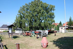
Mönchgut Coastal Fishing Museum
Distance: Approx. 3130 meters
Latitude and longitude: 54.35377778,13.69827778
The Mönchgut Coastal Fishing Museum (German: Mönchguter Küstenfischermuseum) in the German Baltic Sea resort of Baabe shows the methods of production used by fishermen living on Mönchgut, who were influential boat builders. The museum opened on 2 June 2001. The exhibits include, among others, the 9.20 m long motorboat Ossi.
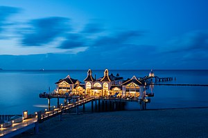
Sellin Pier
Pier in Sellin, Germany
Distance: Approx. 1809 meters
Latitude and longitude: 54.38373,13.69918
Sellin Pier (German: Seebrücke Sellin) is a pier in the Baltic seaside resort of Sellin on the German island of Rügen. The pier has a restaurant near the beach over the water and has a diving gondola (Tauchgondel).
Goldbusch
Distance: Approx. 2157 meters
Latitude and longitude: 54.359066,13.681675
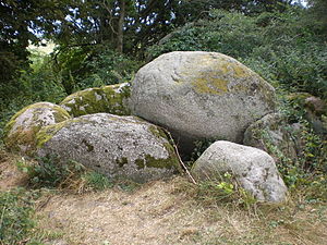
The Goldbusch is a great dolmen (German: Großdolmen), a type prehistoric grave site, that lies between Altensien and Moritzdorf on the German Baltic Sea island of Rügen. The megalithic tomb with Sprockhoff No. 508 was built between 3500 and 2800 B. C. in the New Stone Age as a megalithic site of the Funnelbeaker culture (TBK).

Schwarzer See (Granitz)
Distance: Approx. 1768 meters
Latitude and longitude: 54.3936,13.6705
The Schwarzer See is a lake on the German Baltic Sea island of Rügen. It belongs to the municipality of Sellin and is located in the Granitz Forest. The lake has an area of 23 hectares, a greatest depth of 15 metres and the elevation of its water surface above sea level is 54.2 m above sea level (NHN).
Weather in this IP's area
overcast clouds
19 Celsius
19 Celsius
19 Celsius
19 Celsius
1012 hPa
75 %
1012 hPa
1008 hPa
10000 meters
5.71 m/s
8.38 m/s
125 degree
100 %
06:26:09
19:40:01