Country:
Region:
City:
Latitude and Longitude:
Time Zone:
Postal Code:
IP information under different IP Channel
ip-api
Country
Region
City
ASN
Time Zone
ISP
Blacklist
Proxy
Latitude
Longitude
Postal
Route
Luminati
Country
ASN
Time Zone
Europe/Madrid
ISP
SINGLEHOP-LLC
Latitude
Longitude
Postal
IPinfo
Country
Region
City
ASN
Time Zone
ISP
Blacklist
Proxy
Latitude
Longitude
Postal
Route
db-ip
Country
Region
City
ASN
Time Zone
ISP
Blacklist
Proxy
Latitude
Longitude
Postal
Route
ipdata
Country
Region
City
ASN
Time Zone
ISP
Blacklist
Proxy
Latitude
Longitude
Postal
Route
Popular places and events near this IP address

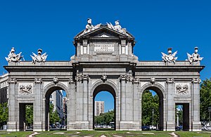
Puerta de Alcalá
Neoclassical gate in Madrid
Distance: Approx. 89 meters
Latitude and longitude: 40.42,-3.68888889
The Puerta de Alcalá is a Neo-classical gate in the Plaza de la Independencia in Madrid, Spain. It was a gate of the former Walls of Philip IV. It stands near the city center and several meters away from the main entrance to the Parque del Buen Retiro. The square is bisected by Alcalá Street, although the street does not cross through the monument, and it is the origin of the Alfonso XII, Serrano and Olózaga streets.

National Archaeological Museum (Madrid)
Archaeology museum in Madrid, Spain
Distance: Approx. 321 meters
Latitude and longitude: 40.423645,-3.68942194
The National Archaeological Museum (Spanish: Museo Arqueológico Nacional; MAN) is a archaeology museum in Madrid, Spain. It is located on Calle de Serrano beside the Plaza de Colón, sharing its building with the National Library of Spain. It is one of the National Museums of Spain and it is attached to the Ministry of Culture.

Paseo de Recoletos
Boulevard in central Madrid, Spain
Distance: Approx. 285 meters
Latitude and longitude: 40.422,-3.6918
Paseo de Recoletos is a wide boulevard in central Madrid leading from Plaza de Cibeles to Plaza de Colón. From west to east it consists of: Two southward lanes The pedestrian walk A southward bus lane Three southward lanes Three northward lanes A median strip lined with trees, flowerbeds, etc. Two northward lanes A northward Bus lane.

Palace of Linares
Cultural property in Madrid, Spain
Distance: Approx. 309 meters
Latitude and longitude: 40.419821,-3.692245
The Palace of Linares (Spanish: Palacio de Linares) is a palace located in Madrid, Spain. It was declared national historic-artistic monument (precursor of the status of Bien de Interés Cultural) in 1976. Located at the plaza de Cibeles.

Church of Saint Manuel and Saint Benedict
Historic site in Madrid, Spain
Distance: Approx. 231 meters
Latitude and longitude: 40.420794,-3.6861
Saint Manuel and Saint Benedict (Spanish: San Manuel y San Benito) is a Catholic church located in Madrid, Spain. The building, which was designed by Fernando Arbós y Tremanti, was built at the beginning of the twentieth century. It was declared Bien de Interés Cultural in 1982.

Recoletos Station
Station in Madrid city centre
Distance: Approx. 306 meters
Latitude and longitude: 40.4225,-3.69166667
Recoletos is a Cercanías station in Madrid city center. It was opened in 1967 as part of the Túnel de la risa project and it is located between Atocha and Nuevos Ministerios stations.

Retiro (Madrid Metro)
Madrid Metro station
Distance: Approx. 226 meters
Latitude and longitude: 40.4203029,-3.6862484
Retiro [reˈtiɾo] is a metro station which serves the Retiro District and Buen Retiro Park in Madrid, Spain.

Plaza de la Independencia (Madrid)
Distance: Approx. 91 meters
Latitude and longitude: 40.42,-3.68861111
The Plaza de la Independencia (Independence Square) is a central square in the Spanish capital, Madrid. It sits at the intersection of Calle de Alcalá (running from east to west), Calle de Alfonso XII (to the south), Calle de Serrano (to the north), Calle de Salustiano Olozaga (to the northwest), and the Paseo de Mexico (to the southeast, running entirely within the Buen Retiro Park). Being centred with the 18th-century gate of Puerta de Alcalá, the Plaza de la Independencia is among the important symbols of the city of Madrid.

Convento de los Agustinos Recoletos (Madrid)
Convent in Madrid, Spain
Distance: Approx. 320 meters
Latitude and longitude: 40.4236,-3.6897
The Convento de los Agustinos Recoletos or Convento de Copacabana, in the city of Madrid, was a convent located in the land now occupied by the National Library, the Museo Arqueológico Nacional, and several city blocks. This convent named the known Paseo de Recoletos of Madrid, name that refers to the Augustinian Recollects (Agustinos Recoletos), former owners of the convent and of the adjacent properties. In this convent the painter Francisco de Zurbarán was buried.

Palacio del Marqués de Portugalete
Spanish palace built in the 1860s
Distance: Approx. 191 meters
Latitude and longitude: 40.41952,-3.69033
The Palacio del Marqués de Portugalete was a grand palace built in the 1860s, located at 56 Calle de Alcalá, on the corner of Calle Alfonso XI, in Madrid. Also known as the Palace of Bailén, it belonged to the family of Francisco Javier Castaños y Aragorri, a descendant of General Francisco Castaños, who was the victor at the Battle of Bailén. It was built by architect Adolfo Ombretch, who also built the nearby palace of Linares.

Historical American Exposition
Exhibition
Distance: Approx. 282 meters
Latitude and longitude: 40.423333,-3.688889
The 1892 Historical American Exposition held in Madrid was intended to mark the four hundredth year of the discovery of America.
Espacio Solo
Private contemporary art museum in Madrid
Distance: Approx. 45 meters
Latitude and longitude: 40.42076579,-3.68830011
Espacio Solo – and its accompanying Colección Solo – is a private contemporary art museum in Madrid, founded by Spanish industrialist Ana Gervás and entertainment executive David Cantolla in 2013 and expanded into its current form in 2018. David Cantolla is the founder of Zinkia Entertainment and a BAFTA award winner for the animated series Pocoyo. The collection comprises 948 paintings, sculptures and drawings by an international group of artists, including established and emerging artists working in figurative art, contemporary sculpture, pop surrealism and new media.
Weather in this IP's area
clear sky
10 Celsius
9 Celsius
8 Celsius
11 Celsius
1020 hPa
80 %
1020 hPa
943 hPa
10000 meters
3.09 m/s
80 degree
08:02:31
17:56:58