185.126.235.142 - IP Lookup: Free IP Address Lookup, Postal Code Lookup, IP Location Lookup, IP ASN, Public IP
Country:
 Spain
SpainRegion:
City:
Location:
Time Zone:
Postal Code:
ISP:
ASN:
language:
User-Agent:
Proxy IP:
Blacklist:
IP information under different IP Channel
ip-api
Country
Region
City
ASN
Time Zone
ISP
Blacklist
Proxy
Latitude
Longitude
Postal
Route
db-ip
Country
Region
City
ASN
Time Zone
ISP
Blacklist
Proxy
Latitude
Longitude
Postal
Route
IPinfo
Country
Region
City
ASN
Time Zone
ISP
Blacklist
Proxy
Latitude
Longitude
Postal
Route
IP2Location
185.126.235.142Country
esRegion
valenciana, comunidad
City
bocairent
Time Zone
Europe/Madrid
ISP
Language
User-Agent
Latitude
Longitude
Postal
ipdata
Country
Region
City
ASN
Time Zone
ISP
Blacklist
Proxy
Latitude
Longitude
Postal
Route
Popular places and events near this IP address

Banyeres de Mariola
Municipality in Valencian Community, Spain
Distance: Approx. 6667 meters
Latitude and longitude: 38.71583333,-0.65722222
Banyeres de Mariola (Valencian: [baˈɲeɾez ðe maɾiˈɔla]), known simply as Banyeres (Spanish: Bañeres [baˈɲeɾes]), is a settlement and a municipality in the north of the province of Alicante (Spain), 860 metres above sea level, with a population of 7,500. The main employer is the local textile industry. The town has a Moorish castle that dates from 1214, and is surrounded by mountains, almond and olive trees.
Ontinyent
Municipality in Valencian Community, Spain
Distance: Approx. 6235 meters
Latitude and longitude: 38.82222222,-0.60722222
Ontinyent is a municipality in the comarca of Vall d'Albaida, Valencian Community, Spain. It is situated on the banks of the Clariano River, a tributary of the Xúquer, and on the Xàtiva–Alcoi railway. Ontinyent is near the Sierra de Mariola Natural Park.

Vinalopó
River in Spain
Distance: Approx. 5261 meters
Latitude and longitude: 38.72,-0.626
The Vinalopó is a small river flowing through the Alicante province, of Spain. It flows from north to south and, with a length of 81 km., it is the longest of the rivers which flows for its entire length within the limits of this province. It discharges into the Mediterranean at Salinas de Santa Pola.

Ontinyent CF
Football club
Distance: Approx. 6917 meters
Latitude and longitude: 38.825574,-0.591213
Ontinyent Club de Fútbol was a Spanish football team based in Ontinyent, in the autonomous community of Valencia. Founded in 1947 it held home games at Estadio El Clariano, with a capacity of 5,000 seats. On 28 March 2019, due to economic problems, the club resigned from the Segunda División B and announced it would cease its activity.
Agullent
Municipality in Valencian Community, Spain
Distance: Approx. 8617 meters
Latitude and longitude: 38.82222222,-0.5475
Agullent (Valencian pronunciation: [aɣuˈʎent]) is a municipality in the comarca of Vall d'Albaida in the Valencian Community, Spain.

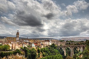
Bocairent
Municipality in Valencian Community, Spain
Distance: Approx. 354 meters
Latitude and longitude: 38.76583333,-0.61277778
Bocairent (Valencian pronunciation: [bokajˈɾent], Spanish: Bocairente) is a municipality in the comarca of Vall d'Albaida in the Valencian Community, Spain.

Serra Mariola Natural Park
Nature reserve in mountains in the Valencian Community, Spain
Distance: Approx. 4277 meters
Latitude and longitude: 38.73361111,-0.59166667
The Serra Mariola Natural Park (Valencian: Parc Natural de la Serra de Mariola; Spanish: Parque Natural de la Sierra de Mariola) is a mountain range in the Valencian Community, Spain, one of the most peripheral offsprings of the Baetic System. Most of its territory is included in a natural park founded in 2002, covering an area of 17,257 ha. The park is surrounded by the towns of Cocentaina and Bocairent and the cities of Ontinyent and Alcoy.

Castle of Banyeres
Historic site in Banyeres de Mariola
Distance: Approx. 6722 meters
Latitude and longitude: 38.715544,-0.657844
The castle of Banyeres (Alicante), Valencian Community (Spain), is an Almohad fortress built in the 13th century, which is situated on the tossal de l'Àguila (Valencian), English: 'Hill of the Eagle', in the geographical center of Banyeres, with an elevation of 830 meters above the sea level. The castle, irregularly shaped, has two enclosures and adapts to the ground. His most significant element is his tower of 17 meters.
Weather in this IP's area
scattered clouds
15 Celsius
14 Celsius
15 Celsius
15 Celsius
1016 hPa
63 %
1016 hPa
937 hPa
10000 meters
9.14 m/s
10.23 m/s
273 degree
29 %