185.126.210.34 - IP Lookup: Free IP Address Lookup, Postal Code Lookup, IP Location Lookup, IP ASN, Public IP
Country:
Region:
City:
Location:
Time Zone:
Postal Code:
ISP:
ASN:
language:
User-Agent:
Proxy IP:
Blacklist:
IP information under different IP Channel
ip-api
Country
Region
City
ASN
Time Zone
ISP
Blacklist
Proxy
Latitude
Longitude
Postal
Route
db-ip
Country
Region
City
ASN
Time Zone
ISP
Blacklist
Proxy
Latitude
Longitude
Postal
Route
IPinfo
Country
Region
City
ASN
Time Zone
ISP
Blacklist
Proxy
Latitude
Longitude
Postal
Route
IP2Location
185.126.210.34Country
Region
tirol
City
hopfgarten im brixental
Time Zone
Europe/Vienna
ISP
Language
User-Agent
Latitude
Longitude
Postal
ipdata
Country
Region
City
ASN
Time Zone
ISP
Blacklist
Proxy
Latitude
Longitude
Postal
Route
Popular places and events near this IP address
Brixen im Thale
Municipality in Tyrol, Austria
Distance: Approx. 6271 meters
Latitude and longitude: 47.45,12.25
Brixen im Thale is a municipality situated at the highest point of the Brixental valley in the Austrian state of Tyrol. Every year on the Feast of Corpus Christi, the village celebrates the traditional Antlassritt. It is also the birthplace of Matthäus Hetzenauer, an Austrian sniper in the 3rd Mountain Division on the Eastern Front of the World War II, who was credited with 345 kills.

Witches' Water
Theme park in Tyrol, Austria
Distance: Approx. 4079 meters
Latitude and longitude: 47.48055556,12.1975
The Witches' Water (German: Hexenwasser) is a theme park at the middle station of the cable car at Söll in Tyrol, Austria. The central part is a water park consisting of ponds and rivulets where children can play a variety of water games. It extends over an area of about 500 meters and is complemented by various alpine restaurants, playgrounds and a petting zoo.

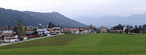
Hopfgarten im Brixental
Municipality in Tyrol, Austria
Distance: Approx. 45 meters
Latitude and longitude: 47.45,12.16666667
Hopfgarten im Brixental is a market town in the Austrian state of Tyrol in the Kitzbühel district. It is located at an elevation of 622 m above sea level. With an area of 166.57 km² it is the largest municipality in the district, and among the largest in Tyrol.

Itter
Municipality in Tyrol, Austria
Distance: Approx. 2825 meters
Latitude and longitude: 47.47055556,12.14388889
Itter [ˈɪtɐ] is a municipality in the Kitzbühel District in the Austrian state of Tyrol located 18.60 km west of Kitzbühel, 5 km southeast of Wörgl, and 2.5 km north of Hopfgarten im Brixental. The village lies on a terrace above the Brixental valley and its main source of income is tourism.

Westendorf, Tyrol
Municipality in Tyrol, Austria
Distance: Approx. 6146 meters
Latitude and longitude: 47.4,12.2
Westendorf is a municipality and a village in the Kitzbühel district in the Austrian state of Tyrol located 13.7 km west of Kitzbühel and 12 km southeast of Wörgl in the Brixental valley. The community is a popular ski resort as well as a popular location for Summer tourism especially for excursions and walking-tours. Westendorf was mentioned for the first time in documents in 1234.

Söll
Municipality in Tyrol, Austria
Distance: Approx. 6221 meters
Latitude and longitude: 47.50361111,12.19194444
Söll is a municipality in the district of Kufstein in the Austrian region of Sölllandl. It is located 9 km south of Kufstein and 9 km east of Wörgl. The village consists of 25 subdivisions.
Itter Castle
C19 building in Itter, Tyrol, Austria
Distance: Approx. 3026 meters
Latitude and longitude: 47.47055556,12.13972222
Itter Castle (German: Schloss Itter) is a 19th-century castle in Itter, a village in Tyrol, Austria. In 1943, during World War II, it was turned into a Nazi prison for French VIPs. The castle was the site of an extraordinary instance of the U.S. Army, German Wehrmacht, Austrian Resistance, and the prisoners themselves fighting side-by-side against the Waffen-SS in the battle for Castle Itter in early May 1945 before the end of the war in Europe.

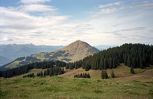
Hohe Salve
Distance: Approx. 3409 meters
Latitude and longitude: 47.46583,12.20583
The Hohe Salve is a well-known mountain located between Kufstein, Wörgl and Kitzbühel in the Austrian state of Tyrol. It is part of the Kitzbühel Alps and is also nicknamed the Rigi of the Tyrol. Its summit is 1,828 m above sea level (AA) high, and in fine weather has a good view of the High Tauern and Zillertal Alps, as well as the Wilder Kaiser, which lies immediately to the north of the Hohe Salve.

Pölven
Distance: Approx. 6825 meters
Latitude and longitude: 47.51083,12.15139
The Pölven is a mountain in the Kitzbühel Alps in the Lower Inn valley in the Austrian state of Tyrol. The mountain actually consists of a ridge with two peaks: the Großer ("Great") and Kleiner ("Small") Pölven, the Großer Pölven (also called the Mittagskogel) reaches a height of 1,595 m (AA). The summit can be scaled over a small and simple Klettersteig.

Windauer Ache
River in Tyrol, Austria
Distance: Approx. 1424 meters
Latitude and longitude: 47.43805556,12.17166667
The Windauer Ache is a mountain stream in Tyrol, Austria, in the scenic Windautal valley in the Kitzbühel Alps. The Ache rises on the Reinkarsee at about 2,200 m (AA), at the foot of the Kröndlhorn, and its middle reaches run through a roughly 4 km (2.5 mi) long gorge. In Hopfgarten the Windauer Ache discharges into the Brixentaler Ache at a narrow point in the valley; the Brixentaler Ache in turn empties into the River Inn at Wörgl.

Battle of Castle Itter
1945 battle of World War II
Distance: Approx. 3026 meters
Latitude and longitude: 47.47055556,12.13972222
The Battle of Castle Itter was fought on 5 May 1945, in the Austrian village of Itter in the North Tyrol region of the country, during the last days of the European Theater of World War II. Troops of the 23rd Tank Battalion of the 12th Armored Division of the US XXI Corps led by Lieutenant John C. "Jack" Lee Jr., a number of Wehrmacht soldiers led by Major Josef "Sepp" Gangl, SS-Hauptsturmführer Kurt-Siegfried Schrader, and recently freed French prisoners of war defended Castle Itter against an attacking force from the 17th SS Panzergrenadier Division until relief from the American 142nd Infantry Regiment of the 36th Division of XXI Corps arrived. The battle is one of two known times during the war in which Americans and Germans fought side by side, the other being Operation Cowboy, and the only known time where an active member of the Waffen-SS fought on the Allied side.

Kelchsauer Ache
River in Austria
Distance: Approx. 1024 meters
Latitude and longitude: 47.4419,12.1615
Kelchsauer Ache is a river of Tyrol, Austria. The source of the Kelchsauer Ache is the confluence of its two headstreams, the Langer-Grund-Ache and the Kurzer-Grund-Ache near Kelchsau. It discharges into the Brixentaler Ache at Hopfgarten im Brixental.
Weather in this IP's area
overcast clouds
5 Celsius
5 Celsius
4 Celsius
6 Celsius
1005 hPa
85 %
1005 hPa
873 hPa
2443 meters
0.98 m/s
0.97 m/s
182 degree
100 %

