185.124.3.126 - IP Lookup: Free IP Address Lookup, Postal Code Lookup, IP Location Lookup, IP ASN, Public IP
Country:
 Great Britain
Region:
City:
Location:
Time Zone:
Postal Code:
ISP:
ASN:
language:
User-Agent:
Proxy IP:
Blacklist:
IP information under different IP Channel
ip-api
Country
Region
City
ASN
Time Zone
ISP
Blacklist
Proxy
Latitude
Longitude
Postal
Route
db-ip
Country
Region
City
ASN
Time Zone
ISP
Blacklist
Proxy
Latitude
Longitude
Postal
Route
IPinfo
Country
Region
City
ASN
Time Zone
ISP
Blacklist
Proxy
Latitude
Longitude
Postal
Route
IP2Location
185.124.3.126Country
gbRegion
wales
City
milford haven
Time Zone
Europe/London
ISP
Language
User-Agent
Latitude
Longitude
Postal
ipdata
Country
Region
City
ASN
Time Zone
ISP
Blacklist
Proxy
Latitude
Longitude
Postal
Route
Popular places and events near this IP address

Milford Haven
Town and community in Pembrokeshire, Wales
Distance: Approx. 615 meters
Latitude and longitude: 51.71418,-5.04274
Milford Haven (Welsh: Aberdaugleddau, lit. 'mouth of the two rivers Cleddau' ) is both a town and a community in Pembrokeshire, Wales. It is on the north side of the Milford Haven Waterway, an estuary forming a natural harbour that has been used as a port since the Middle Ages. The town was founded in 1790 by Sir William Hamilton, who designed a grid street pattern.
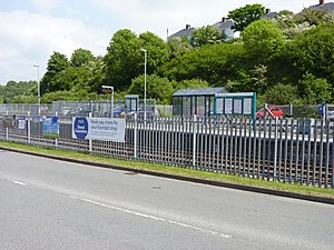
Milford Haven railway station
Railway station in Pembrokeshire, Wales
Distance: Approx. 535 meters
Latitude and longitude: 51.715,-5.041
Milford Haven railway station serves the town of Milford Haven in Pembrokeshire, Wales. Opened on 7 September 1863, it was originally known as Milford, becoming Old Milford by January 1902, and finally being renamed Milford Haven by April 1910. It is the westernmost railway station in Wales, but not in Great Britain as some stations in England and Scotland are further west.
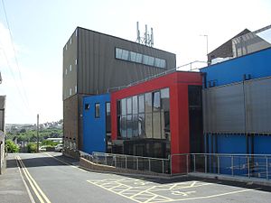
Torch Theatre, Milford Haven
Theatre and cinema in Milford Haven, Pembrokeshire, Wales
Distance: Approx. 492 meters
Latitude and longitude: 51.71527778,-5.04
The Torch Theatre is a not-for-profit theatre in Milford Haven, Wales. Established in 1977, it is one of only three building-based producing theatres in the whole of Wales. The initial concept was a small community enterprise, linked with a Further Education centre in the adjacent building.

Havens Head Retail Park
Distance: Approx. 651 meters
Latitude and longitude: 51.716,-5.042
Havens Head Retail Park is a retail park located in Milford Haven, Wales. Opened in 1998, it is situated centrally between Milford town and Hakin in Hubberston Pill, adjacent to the railway station. It occupies a previously industrial area, the site of a former Jewson branch.

Hakin Docks railway station
Former railway station in Wales
Distance: Approx. 500 meters
Latitude and longitude: 51.709341,-5.038733
Hakin Dock railway station was a railway station in the town of Milford Haven in Pembrokeshire, Wales. Located within the commercial docks at Hakin, it was constructed to service an anticipated transatlantic trade between Milford Haven and New York City. It was the terminus of the Milford Junction Railway, itself a branch of the South Wales Railway.

Milford Haven Museum
Distance: Approx. 435 meters
Latitude and longitude: 51.71256,-5.040396
Milford Haven Museum is a maritime and heritage museum in Milford Haven, Pembrokeshire. Opened in 1991, it has a heavy focus on the maritime history of the town, with exhibitions which explore the fishing and oil industries in the area. The collection also contains information relating to the railway industry in the area, Milford at war, the shipbuilding industry and the Liquefied Natural Gas process.

Pill Fort
Distance: Approx. 913 meters
Latitude and longitude: 51.708709,-5.022629
Pill Fort was a sconce fort located on the northern shore of Milford Haven, Pembrokeshire. It was built by Royalist forces in order to prevent Parliamentarian forces landing at Pembroke Castle, and to protect Royalist forces landing from Ireland. The site was chosen on the west side of the eastern inlet surrounding the site of the later town, known as a Pill.

St Thomas à Becket Chapel, Milford Haven
Distance: Approx. 623 meters
Latitude and longitude: 51.710847,-5.025639
St Thomas à Becket Chapel is a Grade II listed building situated in the town of Milford Haven. It was constructed in 1180 and dedicated to St Thomas Becket. It commanded fine views of the Haven estuary, situated on the north bank in open space.

Milford Central
Electoral ward in Wales
Distance: Approx. 197 meters
Latitude and longitude: 51.714,-5.032
Milford Central is an electoral ward in Pembrokeshire, Wales. It covers the central area of the town of Milford Haven including Pill and Milford Haven Docks. It elects a county councillor to Pembrokeshire County Council and three town councillors to Milford Haven Town Council.
Milford Hakin
Electoral ward in Wales
Distance: Approx. 894 meters
Latitude and longitude: 51.712,-5.047
Milford Hakin is an electoral ward in Pembrokeshire, Wales. It covers the Hakin area of the Milford Haven community, to the west of Milford Haven Docks. It elects a councillor to Pembrokeshire County Council and three councillors to Milford Haven Town Council.
Milford West
Electoral ward in Wales
Distance: Approx. 612 meters
Latitude and longitude: 51.718,-5.037
Milford West is an electoral ward in Pembrokeshire, Wales. It covers the area of the town of Milford Haven immediately east of Milford Haven railway station and Hubberston Pill. The ward elects a county councillor to Pembrokeshire County Council and three town councillors to Milford Haven Town Council.

Milford Haven Town Hall
Municipal Building in Milford Haven, Wales
Distance: Approx. 335 meters
Latitude and longitude: 51.7114,-5.0298
Milford Haven Town Hall (Welsh: Neuadd y Dref Aberdaugleddau) is a municipal structure in Hamilton Terrace, Milford Haven, Pembrokeshire, Wales.
Weather in this IP's area
few clouds
2 Celsius
-3 Celsius
2 Celsius
2 Celsius
1022 hPa
89 %
1022 hPa
1019 hPa
10000 meters
5.83 m/s
8.02 m/s
60 degree
23 %