Country:
 Spain
SpainRegion:
City:
Latitude and Longitude:
Time Zone:
Postal Code:
IP information under different IP Channel
ip-api
Country
Region
City
ASN
Time Zone
ISP
Blacklist
Proxy
Latitude
Longitude
Postal
Route
IPinfo
Country
Region
City
ASN
Time Zone
ISP
Blacklist
Proxy
Latitude
Longitude
Postal
Route
MaxMind
Country
Region
City
ASN
Time Zone
ISP
Blacklist
Proxy
Latitude
Longitude
Postal
Route
Luminati
Country
ESRegion
an
City
antequera
ASN
Time Zone
Europe/Madrid
ISP
Grupo Wifimax, S.l.
Latitude
Longitude
Postal
db-ip
Country
Region
City
ASN
Time Zone
ISP
Blacklist
Proxy
Latitude
Longitude
Postal
Route
ipdata
Country
Region
City
ASN
Time Zone
ISP
Blacklist
Proxy
Latitude
Longitude
Postal
Route
Popular places and events near this IP address

Antequera
Municipality in Andalusia, Spain
Distance: Approx. 652 meters
Latitude and longitude: 37.01833333,-4.55972222
Antequera (Spanish pronunciation: [anteˈkeɾa]) is a city and municipality in the Comarca de Antequera, province of Málaga, part of the Spanish autonomous community of Andalusia. It is known as "the heart of Andalusia" (el corazón de Andalucía) because of its central location among Málaga, Granada, Córdoba, and Seville. The Antequera Dolmens Site is a UNESCO World Heritage site.

El Torcal de Antequera
Historic site
Distance: Approx. 6829 meters
Latitude and longitude: 36.96361111,-4.54555556
El Torcal de Antequera is a nature reserve in the Sierra del Torcal mountain range located south of the city of Antequera, in the province of Málaga of the A45 road in Andalusia, Spain. It is known for its unusual landforms and is regarded as one of the most impressive karst landscapes in Europe. The area was designated a Natural Site of National Interest in July 1929, and a Natural Park Reserve of about 17 square kilometres was created in October 1978.

Dolmen of Menga
Megalithic burial mound in Andalusia, Spain
Distance: Approx. 1564 meters
Latitude and longitude: 37.02458611,-4.54629167
The Dolmen of Menga (Spanish: Dolmen de Menga) is a megalithic burial mound called a tumulus, a long barrow form of dolmen, dating from 3750–3650 BCE approximately. It is near Antequera, Málaga, Spain. It is one of the largest known ancient megalithic structures in Europe.
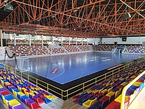
Pabellón Polideportivo Municipal Fernando Argüelles
Arena in Antequera, Spain
Distance: Approx. 436 meters
Latitude and longitude: 37.02253,-4.56863
Pabellón Polideportivo Municipal Fernando Argüelles is an arena in Antequera, Spain. It is primarily used for team handball and is the home arena of BM Antequera. The arena holds 2,575 people.

Dolmen de Viera
Megalithic tomb in Andalusia, Spain
Distance: Approx. 1375 meters
Latitude and longitude: 37.024116,-4.548374
The Dolmen de Viera or Dolmen de los Hermanos Viera is a dolmen—a type of single-chamber megalithic tomb—located in Antequera, province of Málaga, Andalusia, Spain. It is located only 70 metres (230 ft) from the Dolmen de Menga and about 4 kilometres (2.5 mi) from another structure known as Tholos de El Romeral. It was discovered between 1903 and 1905 by brothers Antonio and José Viera from Antequera, who also discovered El Romeral.

Alcazaba of Antequera
Fortress in Antequera, Spain
Distance: Approx. 1149 meters
Latitude and longitude: 37.0141,-4.5577
The Alcazaba of Antequera is a Moorish fortress in Antequera, Spain. It was erected over Roman ruins in the 14th century to counter the Christian advance from the north. The fortress is rectangular in shape, with two towers.

Comarca de Antequera
Comarca in Andalusia, Spain
Distance: Approx. 8236 meters
Latitude and longitude: 37.07972222,-4.62361111
The Comarca de Antequera is a comarca (currently with no administrative role) in Andalusia, southern Spain. It is located in the area of the Surco Intrabético range, on the boundary with the province of Córdoba. The landscape is largely plain (Hoya de Antequera), run by the higher valley of the Guadalhorce river.

Peña de los Enamorados
Historic site
Distance: Approx. 8223 meters
Latitude and longitude: 37.06777778,-4.49
Peña de los Enamorados ("The Lovers' Rock") is a mountain near the city of Antequera, Málaga Province, Andalusia, Spain. It reaches a height of 880 metres above sea level.

Tholos de El Romeral
Megalithic burial mound in Andalusia, Spain
Distance: Approx. 2805 meters
Latitude and longitude: 37.03444444,-4.53555556
Tholos de El Romeral, situated 2.5 kilometres (1.6 mi) north east of the town of Antequera (Andalusia), is one of the most important examples of early Bronze Age architecture in southern Europe. Tholos de El Romeral, also known as Cueva de Romeral (Cave of Romeral) and Dolmen de Romeral, is a megalithic burial site built circa 1800 BCE. It is one of three tombs in the region, the others being Dolmen de Menga and Dolmen de Viera, both situated to the south west. In 2016, the dolmens of Menga, Viera, and El Romeral were all inscribed as a UNESCO World Heritage Site under the name "Antequera Dolmens Site".

Convento de la Magdalena
Building in Andalusia, Spain
Distance: Approx. 4066 meters
Latitude and longitude: 37.00444444,-4.60305556
Convento de la Magdalena was a convent, now a hotel, situated to the southwest of the town of Antequera, Province of Málaga, Spain. Its history was known through the translation of an 18th-century monk's manuscript. In 2009 it was converted into a luxury hotel, known as the Hotel Convento La Magdalena, with 21 rooms.
Weather in this IP's area
overcast clouds
21 Celsius
21 Celsius
21 Celsius
21 Celsius
1010 hPa
48 %
1010 hPa
954 hPa
10000 meters
1.29 m/s
1.35 m/s
31 degree
100 %
08:18:50
19:52:52