Country:
 Netherlands
Region:
City:
Latitude and Longitude:
Time Zone:
Postal Code:
IP information under different IP Channel
ip-api
Country
Region
City
ASN
Time Zone
ISP
Blacklist
Proxy
Latitude
Longitude
Postal
Route
IPinfo
Country
Region
City
ASN
Time Zone
ISP
Blacklist
Proxy
Latitude
Longitude
Postal
Route
MaxMind
Country
Region
City
ASN
Time Zone
ISP
Blacklist
Proxy
Latitude
Longitude
Postal
Route
Luminati
Country
NLASN
Time Zone
Europe/Amsterdam
ISP
LeaseWeb Netherlands B.V.
Latitude
Longitude
Postal
db-ip
Country
Region
City
ASN
Time Zone
ISP
Blacklist
Proxy
Latitude
Longitude
Postal
Route
ipdata
Country
Region
City
ASN
Time Zone
ISP
Blacklist
Proxy
Latitude
Longitude
Postal
Route
Popular places and events near this IP address

Amsterdam
Capital and most populous city of the Netherlands
Distance: Approx. 76 meters
Latitude and longitude: 52.37277778,4.89361111
Amsterdam ( AM-stər-dam, UK also AM-stər-DAM, Dutch: [ˌɑmstərˈdɑm] ; literally, "Dam in the Amstel") is the capital and most populated city of the Netherlands. It has a population of 921,402 within the city proper, 1,457,018 in the urban area and 2,480,394 in the metropolitan area. Located in the Dutch province of North Holland, Amsterdam is colloquially referred to as the "Venice of the North", for its large number of canals, now a UNESCO World Heritage Site.

Dam Square
Town square in Amsterdam
Distance: Approx. 85 meters
Latitude and longitude: 52.373,4.893
Dam Square or the Dam (Dutch pronunciation: [dɑm]) is a town square in Amsterdam, the capital and most populated city of the Netherlands. Its notable buildings and frequent events make it one of the best-known and most important locations in the city and the country.

Amsterdam Ordnance Datum
Vertical datum
Distance: Approx. 95 meters
Latitude and longitude: 52.37305556,4.89277778
Amsterdam Ordnance Datum or Normaal Amsterdams Peil (NAP) is a vertical datum in use in large parts of Western Europe. Originally created for use in the Netherlands, its height was used by Prussia in 1879 for defining Normalnull, and in 1955 by other European countries. In the 1990s, it was used as the reference level for the United European leveling Network (UELN) which in turn led to the European Vertical Reference System (EVRS).

Swissôtel Amsterdam
Distance: Approx. 45 meters
Latitude and longitude: 52.37348056,4.89341111
Swissôtel Amsterdam is a four-star luxury hotel in Amsterdam, Netherlands, and is managed by the Switzerland-based hotel chain Swissôtel Hotels & Resorts. Swissotel Amsterdam is located near Dam Square, in the heart of Amsterdam's historic city centre.

Hendrik van Streek
Dutch painter
Distance: Approx. 160 meters
Latitude and longitude: 52.37386111,4.89183333
Hendrik van Streek or Hendrick van Streeck (baptized 11 April 1659 - buried 19 November 1720) was a Dutch painter and sculptor. He is known for his paintings of church interiors and still lifes.

Anantara Grand Hotel Krasnapolsky Amsterdam
Distance: Approx. 67 meters
Latitude and longitude: 52.3728,4.8941
The Anantara Grand Hotel Krasnapolsky Amsterdam, colloquially known as Kras, is a five-star luxury hotel located on Dam Square in central Amsterdam, Netherlands. Founded in 1865, the hotel has 402 rooms, a convention center, restaurants, and a pier for boats on the Oudezijds Voorburgwal canal. The hotel is part of the Anantara Hotels & Resorts brand under Minor Hotels.

National Monument (Amsterdam)
Cenotaph in Netherlands
Distance: Approx. 76 meters
Latitude and longitude: 52.37277778,4.89361111
The National Monument on Dam Square (Dutch: Nationaal Monument op de Dam) is a 1956 cenotaph in Amsterdam, Netherlands. A national Remembrance of the Dead ceremony is held at the monument every year on 4 May to commemorate the casualties of World War II and subsequent armed conflicts.

Amsterdam-Centrum
Borough of Amsterdam in North Holland, Netherlands
Distance: Approx. 131 meters
Latitude and longitude: 52.37305556,4.89222222
Amsterdam-Centrum is the inner-most borough and historical city centre of Amsterdam, Netherlands, containing the majority of the city's landmarks. Established in 2002, Amsterdam-Centrum was the last area in the city to be granted the status of self-governing borough. The borough is 8.04 km2 and covers the UNESCO-listed Amsterdam canal belt.
Timeline of Amsterdam
Distance: Approx. 131 meters
Latitude and longitude: 52.373056,4.892222
The following is a timeline of the history of the municipality of Amsterdam, Netherlands.
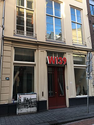
W139
Distance: Approx. 105 meters
Latitude and longitude: 52.3735,4.8956
W139 is an artist-run space established in 1979 on the Warmoesstraat, Amsterdam, the Netherlands. The former theatre was squatted in October 1979 by five young artists as "a movement against the closed world of commercial art and museums". Currently a group of national and international artists are organising different contemporary art shows by following the W139 artist-run approach.

Madame Tussauds Amsterdam
Wax museum in the Netherlands
Distance: Approx. 146 meters
Latitude and longitude: 52.3725,4.8925
Madame Tussauds Amsterdam is a wax museum situated in Amsterdam, the capital city of the Netherlands. It is located in the centre of the city on Dam Square, near the Royal Palace of Amsterdam. Founded in 1970, it was the first Madame Tussauds that was opened in mainland Europe as well as being the first foreign branch of the British institution.

A Garden of Glass
Distance: Approx. 154 meters
Latitude and longitude: 52.373889,4.891944
A Garden of Glass refers to a stained glass window in the Nieuwe Kerk, Amsterdam, designed and installed for the silver jubilee of Queen Beatrix in 2005, by the artist Marc Mulders. In 2004 the National Committee for the Silver Jubilee of Queen Beatrix was formed. The committee settled on a stained glass window in the Nieuwe Kerk as a fitting memorial as that is the location where the Queen was inaugurated.
Weather in this IP's area
light rain
14 Celsius
14 Celsius
14 Celsius
15 Celsius
1016 hPa
85 %
1016 hPa
1015 hPa
10000 meters
6.69 m/s
210 degree
75 %
08:16:41
18:33:00