Country:
 France
Region:
City:
Latitude and Longitude:
Time Zone:
Postal Code:
IP information under different IP Channel
ip-api
Country
Region
City
ASN
Time Zone
ISP
Blacklist
Proxy
Latitude
Longitude
Postal
Route
IPinfo
Country
Region
City
ASN
Time Zone
ISP
Blacklist
Proxy
Latitude
Longitude
Postal
Route
MaxMind
Country
Region
City
ASN
Time Zone
ISP
Blacklist
Proxy
Latitude
Longitude
Postal
Route
Luminati
Country
 LU
LUASN
Time Zone
Europe/Luxembourg
ISP
SkyLink Data Center BV
Latitude
Longitude
Postal
db-ip
Country
Region
City
ASN
Time Zone
ISP
Blacklist
Proxy
Latitude
Longitude
Postal
Route
ipdata
Country
Region
City
ASN
Time Zone
ISP
Blacklist
Proxy
Latitude
Longitude
Postal
Route
Popular places and events near this IP address

Alésia station
Metro station in Paris, France
Distance: Approx. 855 meters
Latitude and longitude: 48.82833333,2.32666667
Alésia (French pronunciation: [alezja]) is a station of the Paris Métro on line 4 in the 14th arrondissement situated in Petit-Montrouge quarter.

Porte d'Orléans station
Metro station in Paris, France
Distance: Approx. 969 meters
Latitude and longitude: 48.82318889,2.32536389
Porte d'Orléans (Général Leclerc) (French pronunciation: [pɔʁt dɔʁleɑ̃ ʒeneʁal ləklɛʁ]) is a station of line 4 of the Paris Métro and a stop on tramway line 3a. It is situated in the 14th Arrondissement, in the quartier of Petit-Montrouge. The station is the former southern terminus of line 4.

Pernety station
Metro station in Paris, France
Distance: Approx. 675 meters
Latitude and longitude: 48.83421,2.31851
Pernety (French: [pɛʁnɛti] ) is a station on line Line 13 of the Paris Métro in the 14th arrondissement. It is named after the nearby rue Pernety, named after Viscount Joseph Marie de Pernety (1766–1856), one of Napoleon's generals and owned the land where the street was built.

Plaisance station
Metro station in Paris, France
Distance: Approx. 342 meters
Latitude and longitude: 48.831553,2.313741
Plaisance (French pronunciation: [plɛzɑ̃s] ) is a station on line Line 13 of the Paris Métro in the 14th arrondissement. It is named after the Château du Maine which was built in the 17th century and possessed a large park. The word "plaisance" is equivalent to the English word "pleasance", that is a pleasure garden.

Porte de Vanves station
Metro station in Paris, France
Distance: Approx. 673 meters
Latitude and longitude: 48.82794,2.30588
Porte de Vanves (French pronunciation: [pɔʁt də vɑ̃v]) is a station on Line 13 of the Paris Métro and a stop on tramway Line 3a in the 14th arrondissement. It is named after the Porte de Vanves, a gate in the 19th century Thiers wall of Paris. Contrary to what its name suggests, it gave access to the commune of Malakoff – the commune of Vanves is instead accessible by Porte Brancion located 250 metres west.

Petit-Montrouge
Distance: Approx. 883 meters
Latitude and longitude: 48.82850556,2.32705278
The quartier du Petit-Montrouge is number 55 of the 80 quartiers administratifs (administrative districts) in Paris. It lies in the 14th Arrondissement, in the south of the capital. It owes its name to the adjacent commune of Montrouge, of which it formed a part before 1860.

Musée Adzak
Distance: Approx. 197 meters
Latitude and longitude: 48.83027778,2.31416667
Musée Adzak, also known as Adzak–Espace d'Art International, is an art museum located at 3, rue Jonquoy, Paris, France. It is located in the Plaisance District, in the southern part of 14th arrondissement. The nearest Paris Métro stop is Plaisance on Line 13.
Saint-Pierre de Montrouge
Church in arrondissement of Paris, France
Distance: Approx. 881 meters
Latitude and longitude: 48.82863889,2.32702778
Saint-Pierre de Montrouge (French pronunciation: [sɛ̃ pjɛʁ də mɔ̃.ʁuʒ]) is a Roman Catholic parish church in the Petit-Montrouge quarter of the 14th arrondissement of Paris. It was built from 1863, during Hausmann's redesign of the city, by Joseph Auguste Émile Vaudremer, the architect charged with designing the 14e arrondissement. It occupies a triangular site bounded by the Avenue du Maine and the avenue du général-Leclerc, and its bell-tower faces the quarter's central square.

Maurice Arnoux
French flying ace
Distance: Approx. 773 meters
Latitude and longitude: 48.82222222,2.31916667
Commandant Maurice Albert Alfred Jean Arnoux (7 September 1895 – 6 June 1940) was a French World War I flying ace credited with five aerial victories. After the end of the First World War, he continued his aviation career during the 1930s as an air racer and aviation record setter until the Second World War. He returned to flying fighter planes during the early days of World War II, but was killed in action in 1940.
Montrouge Cemetery
Cemetery in Paris, France
Distance: Approx. 773 meters
Latitude and longitude: 48.82222222,2.31916667
Montrouge Cemetery (French: Cimetière de Montrouge) is a cemetery in the south of the 14th arrondissement of Paris, located between the Boulevards of the Marshals and Boulevard Périphérique. It was created in 1819 in the commune of Montrouge, but was transferred to the City of Paris in 1925 following a border change. Whilst the most visited grave is that of Coluche, there are many other graves of interest, as well as a crypt.
Lycée Raspail
School in France
Distance: Approx. 474 meters
Latitude and longitude: 48.825334,2.310857
The lycée Raspail is a public lycée located in the 14th arrondissement of Paris. It is a general technological and professional lycée which is known as a trade Lycée "of energy and the environment". It offers courses from second year and licences to pass the general bac, the professional bac, preparatory classes (classe préparatoire aux grandes écoles PCSI/PSI, PTSI/PT, TSI) and BTS FED, MS, ET, TC; it also offers around 150 apprenticeships with 5 CFA and more than a hundred adults studying the GRETA GPI2D to prepare for different professional bacs, BTS and licences.
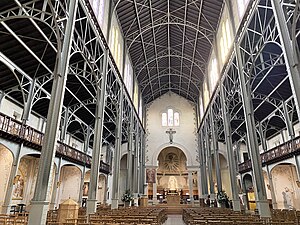
Notre-Dame-du-Travail, Paris
Roman Catholic church
Distance: Approx. 838 meters
Latitude and longitude: 48.836,2.3171
Notre-Dame-du-Travail (also known as Notre-Dame-du-Travail de Plaisance) is a Roman Catholic church located at 59 rue Vercingetorix in the 14th arrondissement of Paris. It was built between 1897 and 1902 for the largely working-class population of the Plaisance neighborhood. It is notable particularly for its exposed steel framework in the interior, resembling a factory, in contrast to the more traditional exterior.
Weather in this IP's area
light rain
12 Celsius
12 Celsius
11 Celsius
13 Celsius
990 hPa
97 %
990 hPa
982 hPa
10000 meters
5.66 m/s
300 degree
100 %
08:03:44
19:11:16