Country:
 Ukraine
Region:
City:
Latitude and Longitude:
Time Zone:
Postal Code:
IP information under different IP Channel
ip-api
Country
Region
City
ASN
Time Zone
ISP
Blacklist
Proxy
Latitude
Longitude
Postal
Route
IPinfo
Country
Region
City
ASN
Time Zone
ISP
Blacklist
Proxy
Latitude
Longitude
Postal
Route
MaxMind
Country
Region
City
ASN
Time Zone
ISP
Blacklist
Proxy
Latitude
Longitude
Postal
Route
Luminati
Country
UAASN
Time Zone
Europe/Kyiv
ISP
Agency for Animal Identification and Registration
Latitude
Longitude
Postal
db-ip
Country
Region
City
ASN
Time Zone
ISP
Blacklist
Proxy
Latitude
Longitude
Postal
Route
ipdata
Country
Region
City
ASN
Time Zone
ISP
Blacklist
Proxy
Latitude
Longitude
Postal
Route
Popular places and events near this IP address

Kyiv-Pasazhyrskyi railway station
Railway station in Kyiv, Ukraine
Distance: Approx. 707 meters
Latitude and longitude: 50.44055556,30.48944444
Kyiv-Pasazhyrskyi (Kyiv-Passenger, Ukrainian: Київ-Пасажирський) is a railway station in the capital of Ukraine, Kyiv. The station is a railway hub consisting of several railroad station buildings, along with its own repair facilities the Kyiv Electric Railcar Repair Shop, a railway depot with railyard, and the railway sports complex, which is integrated into the cityscape. The station is part of the so-called Kyiv Southern Railway loop.

Vokzalna (Kyiv Metro)
Kyiv Metro Station
Distance: Approx. 597 meters
Latitude and longitude: 50.44166667,30.48805556
Vokzalna (Ukrainian: Вокзальна, ) is a station on Kyiv Metro's Sviatoshynsko-Brovarska Line. The station was opened along with the Metro on 6 November 1960 and is named after Kyiv's Central rail station (Vokzal). Decoratively the station is reminiscent of the 1950s stations seen in Moscow Metro, particularly VDNKh.
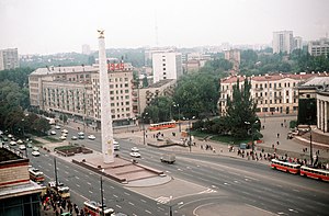
Halytska Square
Square in the Shevchenkivskyi District of Kyiv, Ukraine
Distance: Approx. 163 meters
Latitude and longitude: 50.4469,30.4922
Halytska Square (Ukrainian: Площа Галицька, lit. 'Galicia Square', translit.: Ploshcha Halytska) in Kyiv, the capital of Ukraine, is a large square in the city. The square is in Shevchenkivskyi District and located on Kyiv's main westward thoroughfare (Prospect Beresteiskyi – Tarasa Shevchenka boulevard) being its one of the main transportation hubs. Located on the opposite side of the Old Kyiv, the square is also one of extreme points of the neighborhood along with Maidan Nezalezhnosti.

Halytska Synagogue
Orthodox synagogue in Kyiv, Ukraine
Distance: Approx. 177 meters
Latitude and longitude: 50.44583333,30.48805556
The Halytska Synagogue, also called the Galitska Synagogue or Beit Yaakov Shul, is an Orthodox Jewish synagogue, located at 97a Zhylianska Street, in Kyiv, in the Kyiv Oblast of Ukraine. The congregation worships in the Ashkenazi rite.
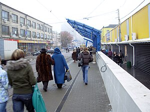
Ploshcha Halytska (Kyiv Light Rail)
Kyiv Light Rail station
Distance: Approx. 133 meters
Latitude and longitude: 50.44625,30.48833333
Ploshcha Halytska (Ukrainian: Площа Галицька; until 2023, Ploshcha Peremohy) is a station on the Kyiv Light Rail. Originally opened in 1978, during the reconstruction of the tramways in 2010 the station was moved to the middle Zhylianska Street and the previous track loops were removed.
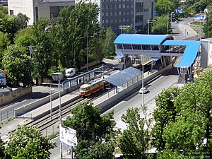
Starovokzalna (Kyiv Light Rail)
Kyiv Light Rail station
Distance: Approx. 339 meters
Latitude and longitude: 50.44388889,30.48916667
Starovokzalna (Ukrainian: Старовокзальна) is the final station of the right-bank line the Kyiv Light Rail, located near the city's main railway station Kyiv-Pasazhyrskyi. It was originally opened in 1989 as a tram stop. On October 16, 2010, the station was reopened after reconstruction to service light rail trams.

Apostolic Nunciature to Ukraine
Diplomatic Mission of the Holy See in Ukraine
Distance: Approx. 580 meters
Latitude and longitude: 50.4518,30.4927
The Apostolic Nunciature to Ukraine the diplomatic mission of the Holy See to Ukraine. It is located in Kyiv. The current Apostolic Nuncio is Archbishop Visvaldas Kulbokas, who was named to the position by Pope Francis on 15 June 2021.

Embassy of Georgia, Kyiv
Diplomatic mission
Distance: Approx. 625 meters
Latitude and longitude: 50.44527778,30.49833333
The Embassy of Georgia in Kyiv is the diplomatic mission of Georgia in Ukraine.

Embassy of Denmark, Kyiv
Diplomatic mission
Distance: Approx. 624 meters
Latitude and longitude: 50.4495,30.4977
The Embassy of the Kingdom of Denmark in Kyiv (Danish: Danmarks ambassade i Kiev) is the diplomatic mission of Denmark in Ukraine. The embassy was also accredited to Georgia, until the establishment of a resident embassy in Tbilisi in 2022.

Sumy railway station
Railway station in Sumy, Ukraine
Distance: Approx. 707 meters
Latitude and longitude: 50.44055556,30.48944444
Sumy (Ukrainian: Суми) is a railway station in Sumy, Ukraine. It is a major freight and passenger station, the main one of the Sumy Directorate of Southern Railways on the Bilopillia-Basy line. It is located in the north of Kovpakivskyi District of Sumy.
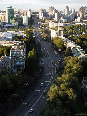
Povitrianykh Syl Avenue
Street in Kyiv, Ukraine
Distance: Approx. 610 meters
Latitude and longitude: 50.44611111,30.48138889
Povitrianykh Syl Avenue is a street located in Shevchenko Raion and Solomianka Raion of Kyiv. It runs from Viacheslava Chornovola Street to Kyiv International Airport.

Hero City monument, Kyiv
Soviet victory memorial in Kyiv, Ukraine
Distance: Approx. 121 meters
Latitude and longitude: 50.447,30.4916
The Hero City monument (officially, the Obelisk in honor of the hero city of Kyiv, Ukrainian: Обеліск на честь міста-героя Києва) is a World War II memorial in Halytska Square in Kyiv, Ukraine. It is a 30 m-tall (98 ft) obelisk that was erected in 1982, during the Ukrainian Soviet Socialist Republic. In its original form it was marked with the dates "1941" and "1945", the starting and ending dates of World War II according to the Soviet Union, and featured a "hero star" reflecting Kyiv's status as a Soviet Hero City.
Weather in this IP's area
clear sky
16 Celsius
15 Celsius
15 Celsius
17 Celsius
1014 hPa
65 %
1014 hPa
999 hPa
10000 meters
0.45 m/s
0.89 m/s
163 degree
2 %
07:09:24
18:21:21